
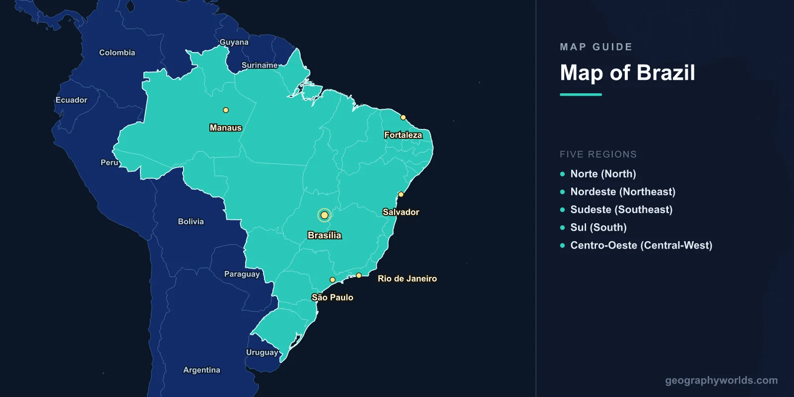
Brazil is the largest country in South America and the fifth-largest in the world, covering 8,515,767 km2 (3,287,956 sq mi) with a population of approximately 216 million. The capital is Brasília (15.7975°S, 47.8919°W). A map of Brazil shows 26 states and one federal district, organized into 5 geographic regions. Brazil occupies nearly half of South America and borders every South American country except Chile and Ecuador.
Introduction
Brazil is bordered by the Atlantic Ocean to the east (7,491 km of coastline), and by 10 countries: French Guiana, Suriname, Guyana, Venezuela, and Colombia to the north; Peru and Bolivia to the west; and Paraguay, Argentina, and Uruguay to the south. Its geography ranges from the Amazon rainforest to the semi-arid Sertão, from the Brazilian Highlands to the Pantanal wetlands.

Geographic Overview
- Area: 8,515,767 km2 (3,287,956 sq mi)
- Population: 216 million (2024)
- Capital: Brasília
- Coordinates: 14.2350°S, 51.9253°W
- Highest Point: Pico da Neblina, 2,994 m (Amazonas)
- Coastline: 7,491 km
Brazil’s geography is dominated by two major features: the Amazon Basin in the north (covering 60% of the country) and the Brazilian Highlands in the south and east. The Amazon Rainforest spans approximately 5.5 million km2 across nine countries, with 60% in Brazil. The Brazilian Highlands, an ancient plateau of weathered rock, cover most of southeastern and southern Brazil.
Major Regions
- Norte (North): Amazon region; 7 states; 45% of Brazil’s area but only 8% of population
- Nordeste (Northeast): 9 states; 27% of population; semi-arid Sertão; Atlantic coast
- Sudeste (Southeast): São Paulo, Rio de Janeiro, Minas Gerais; 42% of population; economic hub
- Sul (South): 3 states; Paraná, Santa Catarina, Rio Grande do Sul; subtropical climate
- Centro-Oeste (Central-West): Brasília; cerrado savanna; agricultural frontier; Pantanal
Brazil’s five regions reflect dramatic differences in climate, vegetation, and development. The Southeast generates about 55% of GDP, while the North—despite covering 45% of the territory—is the least densely populated. The Central-West has become Brazil’s agricultural powerhouse, with soybean, cattle, and corn production expanding across the cerrado savanna.
Major Cities
- São Paulo: 12.3 million (city), 22 million (metro); largest city in the Southern Hemisphere
- Rio de Janeiro: 6.7 million; iconic coastline; Sugarloaf and Corcovado
- Brasília: 3.0 million; planned capital since 1960; modernist architecture
- Salvador: 2.9 million; historic capital; Afro-Brazilian culture; Bahia coast
- Fortaleza: 2.7 million; northeastern coast; tourism hub
- Manaus: 2.2 million; gateway to the Amazon; Meeting of the Waters
São Paulo is the financial capital and the most populous city in the Southern Hemisphere. Rio de Janeiro, nestled between granite peaks and the Atlantic, is arguably the most geographically dramatic city in the world. Brasília was built from scratch in the cerrado in the late 1950s and became the capital in 1960, designed by Oscar Niemeyer and Lucio Costa in the shape of an airplane.
Bodies of Water & Natural Features
- Amazon River: 6,992 km; world’s largest by discharge; 1,100 tributaries
- São Francisco River: 2,914 km; "River of National Unity"; northeast Brazil
- Iguazu Falls: 275 waterfalls spanning 2.7 km; Brazil-Argentina border
- Pantanal: 150,000–195,000 km2; world’s largest tropical wetland
- Amazon Rainforest: 3.3 million km2 in Brazil; 60% of the total Amazon
- Fernando de Noronha: Volcanic archipelago; 350 km offshore; UNESCO marine reserve
The Amazon discharges roughly 209,000 m3/s, more than the next seven largest rivers combined. Near Manaus, the dark Rio Negro and tan Rio Solimões flow side by side for 6 km before mixing—the famous "Meeting of the Waters." Iguazu Falls (275 falls across 2.7 km) is wider than Niagara and taller than Victoria Falls. The Pantanal floods annually, covering an area the size of Portugal.
Bordering Countries
- Argentina: 1,261 km; southern border; Iguazu Falls region
- Bolivia: 3,423 km; western border; Pantanal region; longest border
- Colombia: 1,644 km; northwestern border; Amazon jungle
- Peru: 2,659 km; western border; Amazon basin
- Venezuela: 2,137 km; northern border; tepui highlands
- Uruguay: 1,068 km; southernmost border; Pampas region
- Paraguay: 1,371 km; southwestern border
- Guyana: 1,606 km; northern border
- Suriname: 593 km; northern border
- French Guiana: 730 km; only EU border in South America
Brazil’s 16,885 km of land borders are the third-longest in the world after Russia and China. The country touches every South American nation except Chile and Ecuador. The Brazil-Bolivia border (3,423 km) is the longest, passing through Amazon jungle, cerrado, and Pantanal wetlands.
Key Facts
- Brazil is the fifth-largest country in the world at 8.51 million km2.
- The Amazon River discharges more water than the next seven largest rivers combined.
- Brazil borders 10 countries—every South American nation except Chile and Ecuador.
- The Pantanal is the world’s largest tropical wetland, home to the densest jaguar population on Earth.
- São Paulo’s metro area (22 million) is the largest in the Southern Hemisphere.
Fun Facts
- The Amazon Rainforest produces about 6% of the world’s oxygen and stores 150–200 billion tonnes of carbon.
- Brazil has more species of primates (over 130) than any other country on Earth.
- The Meeting of the Waters near Manaus shows two rivers running side by side in different colors for 6 km.
- Brasília was built in just 41 months from an empty cerrado plateau.
Final Thoughts
Brazil’s map reveals a country of continental scale and extraordinary geographic diversity—from the world’s mightiest river and largest rainforest to sprawling savannas, tropical wetlands, and one of the Southern Hemisphere’s most dramatic coastlines. Understanding its 26 states, five regions, and key natural features is essential for studying South American geography.
Test Your Geography Knowledge!
Think you know your maps? Try our interactive geography games!
Play Geography Games →