
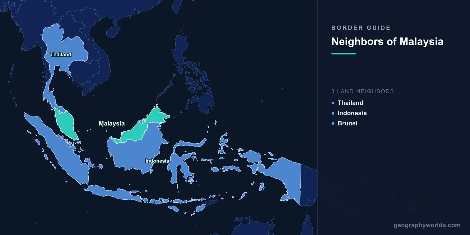
Malaysia shares land borders with three countries: Thailand to the north on the Malay Peninsula, and Indonesia and Brunei on the island of Borneo. Because Malaysia is split across two landmasses separated by the South China Sea, no single neighbour touches both halves of the country, giving Malaysia one of the most unusual border arrangements on Earth.
Malaysia's Split Geography Explained
Malaysia is divided into two regions that lie more than 600 kilometres apart. Peninsular Malaysia (West Malaysia) occupies the southern end of the Malay Peninsula and accounts for roughly 40 percent of the country's land area but the great majority of its population, industry, and political power. East Malaysia consists of the states of Sarawak and Sabah on the northern coast of the island of Borneo, the third-largest island in the world. Between the two halves stretches the South China Sea.
This division is the key to understanding Malaysia's borders. The peninsula has only one land neighbour, Thailand, while the Borneo states touch both Indonesia and Brunei. The two regions feel like different worlds: the peninsula is densely settled, urbanised, and home to Kuala Lumpur, while Borneo is sparsely populated, heavily forested, and culturally distinct, with large indigenous Dayak and other communities.

Overview of Malaysia's Borders
- Total Land Borders: 2,669 km
- Number of Land Neighbors: 3 countries
- Peninsular Border: Thailand (595 km)
- Borneo Borders: Indonesia (1,881 km), Brunei (266 km)
Malaysia's borders span two distinct regions separated by over 600 km of the South China Sea. The Thai border on the peninsula is culturally and politically different from the Borneo borders, reflecting Malaysia's unique dual geography. The Indonesian border on Borneo is by far the longest, crossing dense equatorial rainforest, while the short Brunei border wraps around a tiny but wealthy sultanate.
Malaysia also has significant maritime boundaries with Singapore (connected by two causeways), the Philippines, Vietnam, and Indonesia's various islands. The Strait of Malacca between peninsular Malaysia and Indonesia's Sumatra is one of the world's most vital shipping lanes, making Malaysia a gatekeeper of global maritime trade.
Peninsular Neighbor: Thailand
- Border Length: 595 km
- Key Features: Perlis, Kelantan, Golok River
- Cultural Zone: Malay-Muslim population on the Thai side
Thailand's 595 km border runs across the Malay Peninsula from the Andaman Sea coast in the west to the Gulf of Thailand in the east. It touches four Malaysian states: Perlis, Kedah, Perak, and Kelantan. Much of the boundary follows the rugged Titiwangsa mountain range and stretches of tropical rainforest, while the Golok (Kolok) River forms part of the eastern border between Malaysia's Kelantan state and Thailand's Narathiwat province.
The border has deep cultural significance because the Malay-Muslim population extends across it into Thailand's southern provinces. A long-running separatist insurgency in Thailand's deep south, covering Pattani, Yala, and Narathiwat, occasionally affects border security and has led both governments to tighten checkpoints. Despite this, cross-border trade and movement remain busy. Towns such as Padang Besar and Bukit Kayu Hitam handle heavy road and rail traffic, with Malaysians crossing for tourism and goods, and Thai workers heading south for employment in plantations and factories.
Borneo Neighbor: Indonesia
- Border Length: 1,881 km
- Key Features: Borneo rainforest, Kalimantan
- Key Crossings: Tebedu-Entikong, Serikin
Indonesia's 1,881 km border on Borneo is Malaysia's longest land boundary, separating the Malaysian states of Sarawak and Sabah from Indonesia's five Kalimantan provinces. The line crosses the Heart of Borneo, one of the most biodiverse regions on Earth, home to orangutans, pygmy elephants, sun bears, and thousands of plant and animal species found nowhere else. The terrain is among the most challenging of any border, running through dense jungle and over remote mountain ridges with few formal crossings.
The main legal land crossing is at Tebedu (Sarawak) and Entikong (West Kalimantan), the only one regularly used for international road traffic. Cross-border communities, particularly the Dayak indigenous peoples, share kinship and trading ties that predate national boundaries entirely. Markets such as Serikin draw Indonesian traders into Sarawak. Environmental pressure is intense on both sides, with illegal logging and palm-oil expansion threatening the forest. The trilateral Heart of Borneo conservation initiative, signed by Malaysia, Indonesia, and Brunei in 2007, aims to protect roughly 220,000 km² of rainforest as a cross-border effort.
Borneo Neighbor: Brunei
- Border Length: 266 km
- Key Feature: Brunei is almost entirely surrounded by Malaysia
- Historical Context: British colonial boundaries
Brunei's 266 km border is unusual because Sarawak almost completely encircles the small, oil-rich sultanate. Brunei is split into two non-contiguous parts by Sarawak's Limbang district, which separates Brunei's eastern Temburong district from the main bulk of the country. The boundary was drawn during the British colonial era, when both Brunei and Sarawak (then ruled by the Brooke "White Rajahs") fell under British influence, and the cession of Limbang in 1890 created the geography that survives today.
Relations between Malaysia and Brunei are generally warm. Both are members of ASEAN, share Malay-Muslim heritage, and cooperate closely on border security and energy. The Limbang question lingers in the background, as Brunei has historically been reluctant to formally accept Malaysian sovereignty over the district, though the dispute is dormant in practice. In 2020 the Sultan Haji Omar 'Ali Saifuddien Bridge opened across Brunei Bay, finally connecting Temburong to the rest of Brunei without travellers needing to cross Malaysian territory.
Maritime Borders and Strategic Position
- Strait of Malacca: Between peninsular Malaysia and Sumatra
- Singapore: Connected by two causeways across the Johor Strait
- Maritime Disputes: Sovereignty claims in the South China Sea
Malaysia's maritime position is strategically vital. The Strait of Malacca, between peninsular Malaysia and Indonesia, carries roughly a quarter of the world's seaborne trade and is one of the busiest and most strategically sensitive waterways anywhere. Singapore sits at the southern tip of the peninsula, linked to Malaysia by the Johor-Singapore Causeway (opened in 1923) and the Second Link bridge near Tuas. More than 300,000 people cross between Johor Bahru and Singapore each day, making it one of the busiest land crossings in the world.
In the South China Sea, Malaysia maintains claims that overlap with those of China, Vietnam, the Philippines, Brunei, and Taiwan, centred on features in the Spratly Islands. Malaysia generally takes a quieter, less confrontational stance than some claimants, preferring negotiation, but it has expanded naval and coast-guard patrols to assert control over the waters and resource-rich seabed within its exclusive economic zone.
Key Facts
- Land neighbours: 3 — Thailand (peninsula), Indonesia (Borneo), and Brunei (Borneo)
- Longest border: Indonesia, at 1,881 km across the Heart of Borneo
- Shortest border: Brunei, at 266 km, with Malaysia nearly surrounding it
- Total land borders: 2,669 km combined
- Strait of Malacca: Carries about 25% of global seaborne trade
- Busiest crossing: Over 300,000 people cross to/from Singapore daily
- Split geography: The two halves of Malaysia lie 600+ km apart across the South China Sea
Fun Facts
- Malaysia's Limbang district divides Brunei into two separate parts.
- The Johor-Singapore Causeway is one of the busiest border crossings in the world by daily traffic.
- Borneo's rainforest, crossed by the Indonesian border, is estimated to be around 130 million years old.
- Malaysia's two halves are separated by over 600 km of the South China Sea.
- Despite surrounding Brunei almost entirely, Malaysia has only one short land border with it.
Frequently Asked Questions
How many countries does Malaysia border?
Malaysia borders three countries by land: Thailand on the Malay Peninsula, and Indonesia and Brunei on the island of Borneo. It also shares important maritime boundaries with Singapore, the Philippines, Vietnam, and Indonesia.
Which country shares the longest border with Malaysia?
Indonesia shares Malaysia's longest land border at 1,881 km, running across the island of Borneo between the Malaysian states of Sarawak and Sabah and Indonesia's Kalimantan provinces.
Is Brunei surrounded by Malaysia?
Almost entirely. The Malaysian state of Sarawak wraps around Brunei on the landward side, and Sarawak's Limbang district even splits Brunei into two separate parts. Brunei's only sea frontage faces the South China Sea.
Does Malaysia share a border with Singapore?
Malaysia and Singapore do not share a land border, but they are connected across the narrow Johor Strait by two causeways: the Johor-Singapore Causeway and the Second Link. The boundary between them is a maritime one.
Test Your Knowledge!
Think you know which countries share borders? Try our geography games!
Play Geography Games →