
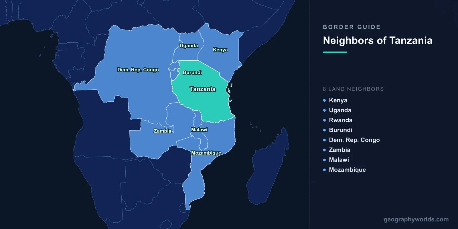
Tanzania borders eight countries: Kenya and Uganda to the north, Rwanda and Burundi to the north-west, the Democratic Republic of the Congo to the west, Zambia and Malawi to the south-west, and Mozambique to the south. Its land and lake borders total about 4,161 km. The longest is with Mozambique (840 km) and the shortest with Rwanda (222 km). The border with the Democratic Republic of the Congo runs entirely down the middle of Lake Tanganyika, so the two countries share no land frontier. Tanzania is the only country that borders all three of Africa's largest lakes: Victoria, Tanganyika and Malawi.
| Neighbour | Border length | What the border follows |
|---|---|---|
| Mozambique | 840 km | The Ruvuma River |
| Kenya | 775 km | A straight colonial line, bent round Kilimanjaro |
| Burundi | 589 km | Hills and rivers east of Lake Tanganyika |
| Malawi | 512 km | The Songwe River and Lake Malawi (disputed) |
| DR Congo | 479 km | The middle of Lake Tanganyika |
| Uganda | 391 km | Lake Victoria and the 1° S parallel |
| Zambia | 353 km | Highlands between Lakes Tanganyika and Malawi |
| Rwanda | 222 km | The Kagera River |
Tanzania is the largest country in East Africa at about 947,000 km², and it has about 1,400 km of Indian Ocean coast. Eight neighbours makes it one of the most connected countries on the continent. In this part of Africa, only the Democratic Republic of the Congo has more neighbours, with nine, while Zambia matches Tanzania with eight.
Lake Victoria: Kenya and Uganda in the North
The northern border crosses Lake Victoria, the largest lake in Africa, of which Tanzania holds about 49 per cent, Uganda about 45 per cent and Kenya about 6 per cent. East of the lake, the border with Kenya runs as a straight line south-east to the coast, drawn between Britain and Germany in 1886, with a famous bend so that Kilimanjaro, at 5,895 m, falls on the Tanzanian side. Kenya's Amboseli and Tsavo West national parks lie just across the line, with views of the mountain. The border cuts across the single ecosystem of the Serengeti and Kenya's Masai Mara, which the great wildebeest migration crosses each year. Our guide to the countries that border Kenya covers that frontier from the north.
West of the lake, the border with Uganda follows the parallel of 1° S across the Kagera region. It has seen war. In October 1978, Idi Amin's Ugandan army invaded and annexed the Kagera Salient, the land north of the Kagera River. Tanzania's president, Julius Nyerere, responded with a counter-offensive that drove the invaders out and went on to capture Kampala in April 1979, ending Amin's rule. Today the border region is crossed by the planned East African Crude Oil Pipeline, which is designed to carry Ugandan oil about 1,440 km to the Tanzanian port of Tanga.
Rwanda and Burundi: Rivers and Refugees
Tanzania's short border with Rwanda follows the Kagera River, whose headwaters are among the remotest sources of the Nile. At Rusumo Falls, the main crossing, a bridge carries the road over the river. In late April 1994, during the genocide in Rwanda, around 250,000 people crossed that bridge into Tanzania in about a day, one of the fastest mass exoduses ever recorded. A hydroelectric plant now built at the falls is shared by Rwanda, Burundi and Tanzania.
The border with Burundi runs through hills east of Lake Tanganyika. Tanzania has sheltered hundreds of thousands of Burundian refugees during that country's repeated crises, in camps in the Kigoma region such as Nyarugusu. Just north of Kigoma, on the shore of Lake Tanganyika, lies Gombe Stream National Park, where Jane Goodall began her study of wild chimpanzees in 1960.
Lake Tanganyika: A Border Down the Middle of the Water
Tanzania's border with the Democratic Republic of the Congo, about 479 km, lies entirely in Lake Tanganyika. The lake fills part of the Western Rift and is about 670 km long, the longest freshwater lake in the world, and about 1,470 m deep, second only to Lake Baikal. The border runs down its middle, so the Congo's mountains are visible across the water from Kigoma on a clear day without the two countries ever touching on land.
The lake is also home to one of the most remarkable ships in Africa. The MV Liemba was built in Germany in 1913 as the Graf von Götzen, shipped in pieces to Kigoma and assembled there. It was scuttled by its German crew in 1916, raised by the British in the 1920s, and has since carried passengers and cargo along the Tanzanian shore to Zambia for about a century. More about the lake is in our guide to Lake Tanganyika.
Zambia: The Busiest Southern Crossing
The border with Zambia crosses the highlands between the southern ends of Lakes Tanganyika and Malawi. It is the gateway for trade from much of south-central Africa to the port of Dar es Salaam. The crossing at Tunduma, on the Tanzanian side, and Nakonde, on the Zambian side, is among the busiest in the region, with long queues of trucks carrying copper and other goods along the TanZam Highway, which links Dar es Salaam with the Zambian capital, Lusaka. The TAZARA railway, opened in 1975 with Chinese financing and labour, runs about 1,860 km from central Zambia to Dar es Salaam through the same corridor.
Malawi: A Lake Both Countries Claim
The border with Malawi follows the Songwe River down to the northern tip of Lake Malawi, the third-largest lake in Africa, which Tanzanians call Lake Nyasa, and here it becomes disputed. Malawi holds that the border runs along the Tanzanian shore, so that the entire northern part of the lake belongs to Malawi, citing the 1890 Anglo-German treaty that set the boundary. Tanzania argues that the border should run down the middle of the lake, as is usual for lakes between states. The dispute flared in 2012, when Malawi licensed oil exploration in the northern lake. Mediation led by former African heads of state has not resolved it. Our guide to Lake Malawi covers the lake's geography.
Mozambique: The Ruvuma River
Tanzania's longest border, 840 km, follows the Ruvuma River, which rises in the highlands east of Lake Malawi and flows east to the Indian Ocean. For decades there was no road bridge. The Unity Bridge, opened in 2010 near Negomano, was the first road crossing of the river between the two countries. The river's lower reaches border the Cabo Delgado province of Mozambique, where an Islamist insurgency has been fought since 2017, and the security of the frontier has become a concern for both governments.
The Indian Ocean Frontier
Tanzania's coast, about 1,400 km long, has been a trading frontier for more than a thousand years. Swahili city-states grew up along it, trading gold, ivory and slaves with Arabia, Persia and India. Their most impressive remains, the ruins of Kilwa Kisiwani, including its great mosque and the palace of Husuni Kubwa, are a World Heritage Site. Offshore lie the islands of Zanzibar, Unguja and Pemba, which keep their own president and government within the union, and Mafia Island, whose waters are a marine park.
The sea frontier has become economically important. In the 2010s large deposits of natural gas were found in deep water off southern Tanzania, near the maritime boundary with Mozambique, which the two countries settled by agreement in 2011. The port of Dar es Salaam, expanded in recent years, handles cargo not only for Tanzania but for landlocked Zambia, Malawi, Rwanda, Burundi, Uganda and eastern Congo.
Peoples on Both Sides of the Lines
Like most African borders, Tanzania's were drawn across the lands of existing peoples. The Maasai live on both sides of the Kenyan border, moving their herds across the Serengeti and Mara plains. The Makonde, famous for their ebony carvings, live on both banks of the Ruvuma, in Tanzania and Mozambique. The Haya of Kagera have relatives in Uganda. Tanzania is unusual in Africa for how widely its people share a single African language. Julius Nyerere, who translated Shakespeare into Swahili himself, made Swahili the national language after independence, and it is spoken almost everywhere in the country. It is also a common language across much of East Africa, and in 2022 the African Union adopted it as one of its official working languages.
How Tanganyika and Zanzibar Became Tanzania
Most of Tanzania's borders were drawn when the mainland was German East Africa, from the 1880s. After the First World War Britain took the colony as the mandate of Tanganyika, while Belgium took Ruanda-Urundi, the future Rwanda and Burundi, which explains why that part of the western border is so recent. Tanganyika became independent in 1961, and in 1964 it united with the islands of Zanzibar, independent in 1963, to form the United Republic of Tanzania, whose name combines the two. The capital moved officially from Dar es Salaam to Dodoma, in the centre of the country, although Dar es Salaam remains the largest city and main port, and the most important link between Tanzania's eight neighbours and the sea.