
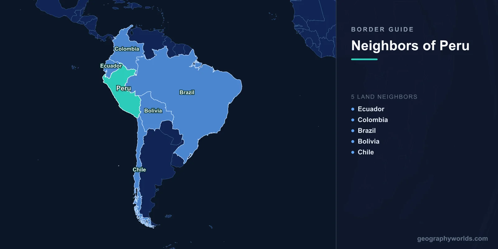
Peru shares land borders with five countries: Ecuador to the northwest, Colombia to the northeast, Brazil to the east, Bolivia to the southeast, and Chile to the south. These borders span approximately 7,062 kilometers across three dramatically different geographic zones.
Introduction
Peru's borders traverse the full range of South American geography: the arid Pacific coast, the soaring Andes Mountains with peaks over 6,000 meters, and the vast Amazon rainforest that covers over 60% of the country. The borders have been shaped by pre-Columbian civilizations, Spanish colonial boundaries, and a series of territorial wars in the 19th and 20th centuries that left deep marks on Peru's relationships with its neighbors.

Overview of Peru's Borders
- Total Land Borders: 7,062 km
- Number of Neighbors: 5 countries
- Longest Border: Brazil (2,995 km)
- Shortest Border: Chile (168 km)
Peru's borders are defined by a mix of the Andes, Amazon rivers, and Pacific coastal features. The Brazilian border, by far the longest at 2,995 km, runs through dense Amazon rainforest. The Bolivian border crosses the Altiplano, the high plateau shared between the two countries, including the shores of Lake Titicaca. The Chilean border is surprisingly short at 168 km, crossing the Atacama Desert.
Peru's borders have been contested more frequently than those of most South American nations. Wars with Chile (1879-1884), Colombia (1932-1933), and Ecuador (most recently in 1995) have all resulted in territorial changes or tensions. The 1998 Brasilia Presidential Act finally resolved the long-running border dispute with Ecuador, establishing peace after over a century of conflict.
Northern Neighbors: Ecuador and Colombia
- Ecuador Border: 1,529 km
- Colombia Border: 1,494 km
- Key Features: Andes Mountains, Maranon River, Amazon tributaries
- Historical Disputes: Cenepa War with Ecuador (1995), resolved in 1998
The Ecuadorian border runs 1,529 km from the Pacific coast through the Andes and into the upper Amazon basin. This border was disputed for over 150 years, leading to multiple armed conflicts including the 1941 Peruvian-Ecuadorian War and the 1995 Cenepa War. The 1998 peace agreement finally resolved the dispute, with guarantor nations (Argentina, Brazil, Chile, and the US) helping establish the definitive boundary.
The Colombian border at 1,494 km runs through the remote northern Amazon, largely following the Putumayo River. This border was established after the brief Colombia-Peru War of 1932-1933, which began when Peruvian civilians seized the Colombian town of Leticia on the Amazon. The border region remains one of the most remote and sparsely populated areas in both countries, accessible primarily by river.
Eastern Neighbor: Brazil
- Border Length: 2,995 km
- Key Rivers: Javari, Purus, Ucayali tributaries
- Terrain: Dense Amazon rainforest
- Indigenous Peoples: Home to several uncontacted tribes
The Brazilian border is Peru's longest at 2,995 km, running through the heart of the Amazon rainforest. Much of this boundary follows rivers, including the Javari River, which forms a significant portion of the border. The border region is extraordinarily remote, with some areas accessible only after days of river travel. It is home to some of the highest biodiversity on Earth and to several uncontacted indigenous groups.
The border was established through a series of treaties in the 19th century, notably the Treaty of Limits of 1851. The region faces challenges from illegal logging, gold mining, and drug trafficking. Brazil and Peru have cooperated on border security and Amazon conservation, though enforcement is difficult given the vast distances and dense jungle. The Interoceanic Highway, completed in 2011, now connects the two countries by road.
Southern Neighbors: Bolivia and Chile
- Bolivia Border: 1,075 km
- Chile Border: 168 km
- Key Features: Lake Titicaca, Altiplano, Atacama Desert
- Lake Titicaca: 3,812 m above sea level, shared between Peru and Bolivia
The Bolivian border runs 1,075 km across the Altiplano, the high-altitude plateau averaging 3,750 meters above sea level. Lake Titicaca, the world's highest navigable lake at 3,812 meters, straddles this border and holds immense cultural significance for both countries. The lake was sacred to the Inca civilization and today is surrounded by indigenous Aymara and Quechua communities. Puno on the Peruvian side faces Copacabana on the Bolivian shore.
Peru's shortest border is with Chile at just 168 km, crossing the extremely arid Atacama Desert region. This border was established after the War of the Pacific (1879-1884), in which Chile defeated Peru and Bolivia and annexed the mineral-rich Atacama region. The treaty of 1929 established the current boundary, with the city of Tacna returning to Peru and Arica remaining with Chile. Despite historical tensions, relations today are largely cooperative.
Cross-Border Relations and Trade
- Andean Community: Member with Colombia, Ecuador, Bolivia
- Pacific Alliance: Member with Colombia, Mexico, Chile
- Lake Titicaca: Joint management with Bolivia
- Top Regional Partner: Chile and Colombia
Peru is a member of both the Andean Community and the Pacific Alliance, giving it strong trade ties with its neighbors. Chile has become Peru's most important regional trade partner despite their historical rivalry, with bilateral trade exceeding $3 billion annually. Colombia and Ecuador are also significant partners, and all three Andean nations cooperate on issues from drug interdiction to environmental protection.
Cross-border cultural connections run deep. The Aymara and Quechua peoples span the borders of Peru, Bolivia, and Ecuador, maintaining traditions that predate European colonization. Peru shares the management of Lake Titicaca with Bolivia through a binational authority. The Interoceanic Highway linking Peru to Brazil has opened new trade possibilities, while the Pacific coastline gives Peru a strategic role in trans-Pacific commerce.
Key Facts
- Peru borders 5 countries: Ecuador, Colombia, Brazil, Bolivia, and Chile.
- Peru's longest border is with Brazil at 2,995 km through the Amazon rainforest.
- Lake Titicaca on the Bolivia border is the world's highest navigable lake at 3,812 m.
- Peru's shortest border is with Chile at just 168 km across the Atacama Desert.
- The Peru-Ecuador border dispute was finally resolved peacefully in 1998 after over a century of conflict.
Fun Facts
- The Peruvian-Ecuadorian border dispute led to four armed conflicts over 150 years before being resolved in 1998.
- Lake Titicaca on the Bolivia border contains 41 islands, including the Uros floating islands made of reeds.
- Peru's Amazon border region is home to some of the world's last uncontacted indigenous peoples.
- The War of the Pacific (1879-1884) cost Peru its entire southern coastal province, reshaping the Chile border.
Final Thoughts
Peru's five borders traverse the full spectrum of South American geography, from the Pacific coast through the soaring Andes to the immense Amazon basin. Shaped by ancient civilizations, colonial boundaries, and modern diplomacy, these borders connect Peru to the diverse cultures and landscapes of a continent, with Lake Titicaca, the Amazon rainforest, and the Andes providing some of the most dramatic border landscapes on Earth.
Test Your Knowledge!
Think you know which countries share borders? Try our geography games!
Play Geography Games →