
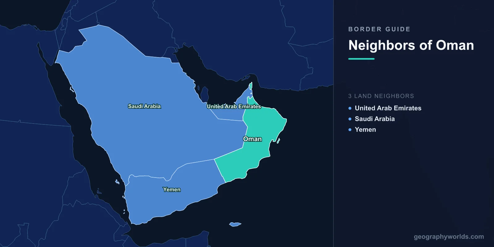
Oman shares land borders with three countries: the United Arab Emirates to the north-west, Saudi Arabia to the west, and Yemen to the south-west. Its coastline runs roughly 2,100 kilometres along the Gulf of Oman and the Arabian Sea, and one detached piece of Omani territory controls the southern shore of the Strait of Hormuz. The borders themselves are among the most recently and most thoroughly settled in the Arabian Peninsula.
Musandam, the Exclave That Holds the Strait
The Musandam peninsula is Omani territory separated from the rest of Oman by the United Arab Emirates. It juts north into the Strait of Hormuz, a landscape of steep limestone ridges dropping into deep inlets that are often described as fjords, though they were formed by tectonic subsidence rather than by glaciers.
Its strategic importance is difficult to overstate. The Strait of Hormuz is around 33 kilometres wide at its narrowest, and roughly a fifth of global oil consumption passes through it. The shipping lanes run through Omani territorial waters on the Musandam side, which means the world's most important oil chokepoint is navigated, in practice, along an Omani coast.
That geography is a substantial part of why Oman has maintained working relations with Iran throughout every period of confrontation. The two states share responsibility for the strait, and neither has an interest in the other treating it as a weapon.
An Enclave Inside an Enclave
Oman also owns Madha, a small territory of about 75 square kilometres entirely surrounded by the United Arab Emirates, roughly halfway between Musandam and the Omani mainland.
Inside Madha sits Nahwa, a village of a few dozen houses that belongs to the UAE — an enclave within an enclave, and one of a very small number of second-order enclaves anywhere on earth. Driving from the UAE into Madha and then into Nahwa means crossing an international boundary twice and ending up back where you started, nationally speaking.
The arrangement dates from the 1930s, when local villages were asked which ruler they wished to follow. Madha's people chose the Sultan of Muscat; Nahwa's chose the ruler of Sharjah. The borders were drawn to match, and nobody has since seen a reason to change them. There are no checkpoints, the electricity and phone networks differ, and the road signs change colour.
The Buraimi Crisis
Oman's western frontier was not always quiet. The Buraimi oasis, a cluster of villages on what is now the UAE-Oman boundary, was claimed by Saudi Arabia in the 1940s and 1950s, at a point when oil prospects made previously worthless desert suddenly worth having.
Saudi forces occupied one of the villages in 1952. Arbitration was attempted at Geneva and collapsed amid allegations of bribery, and in 1955 British-officered forces of the Trucial Oman Levies expelled the Saudi party. The dispute soured Saudi-British relations badly and was not formally resolved until the Treaty of Jeddah in 1974, under which Saudi Arabia dropped its claim in exchange for territory elsewhere and a share in an oilfield.
Today the oasis is divided between Al Ain in the UAE and Al Buraimi in Oman, two towns that function as one urban area with a controlled crossing between them.
Borders Finished Late, and Finished Properly
Oman's boundary with Saudi Arabia, running through the Rub al Khali, was agreed in 1990 and subsequently demarcated — one of the first frontiers across the Empty Quarter to be defined on the ground rather than left as a dotted line.
The UAE boundary was settled by agreement in 1999 and finalised in 2003, and the Yemen boundary was agreed in 1992 and demarcated over the following years without significant difficulty.
This gives Oman something unusual in the region: three land borders, all defined by treaty, all demarcated, none in dispute. For a state whose neighbours have argued over sand for decades, that record is a deliberate diplomatic achievement rather than an accident.
Dhofar, and a Border That Was a Front Line
The Yemeni frontier was not always settled. From 1962 to 1976, Oman fought the Dhofar rebellion in its southern province, against insurgents who began as a regional movement and became Marxist, supplied and sheltered from the neighbouring People's Democratic Republic of Yemen.
The war was won by a combination of British special forces, Iranian troops sent by the Shah, Jordanian assistance, and a counter-insurgency strategy under Sultan Qaboos that combined amnesty with development spending — wells, schools and clinics in the Jebel.
Once the PDRY ceased to exist with Yemeni unification in 1990, the two states had every reason to fix their boundary, and they did so within two years. Since 2015 the Omani crossing at Sarfayt has been one of very few functioning land routes out of Yemen, used by traders and by people seeking medical treatment.
Neutrality as a Border Policy
Oman's posture toward its neighbours is distinctive. It declined to join the Saudi-led coalition in Yemen, refused to participate in the blockade of Qatar and kept its ports open to Qatari shipping throughout, and has maintained relations with Iran continuously.
That has made it the region's venue for talks nobody else can host: the secret channel between the United States and Iran that led to the nuclear negotiations ran through Muscat, and Omani mediation has featured in hostage releases, Yemeni talks and back-channel contacts across several conflicts.
The policy has a geographic basis. A state that sits on one side of Hormuz, shares a long border with a country at war, and depends on shipping rather than pipelines has strong reasons to be on speaking terms with everyone.
Duqm, and Ports Beyond the Strait
Oman's coastline gives it something its Gulf neighbours lack: ports outside the Strait of Hormuz. Salalah in the far south and the new industrial port at Duqm on the Arabian Sea can be reached without passing through the chokepoint at all.
That is a considerable strategic asset in a region where the closure of Hormuz is a standing threat, and it is why Duqm has attracted investment from India, China, Britain and others. During the Qatar blockade, Omani ports handled the rerouted traffic that had previously come overland from Saudi Arabia.
Frankincense, and a Very Old Frontier
Dhofar's monsoon-fed hills, the khareef that turns the Salalah region green each summer, produced the frankincense that supplied the temples of Egypt, Israel, Greece and Rome. The Land of Frankincense sites — the trees of Wadi Dawkah, the caravan oasis at Shisr, and the ports of Khor Rori and Al Baleed — are inscribed by UNESCO.
The trade routes ran north across what is now the Saudi and Yemeni border, and the caravan cities along them were the region's first frontier towns. Oman's modern borders are barely thirty years old; the movement they regulate is roughly three thousand.
Ras al-Jinz, and a Coast Facing India
Oman's eastern cape at Ras al-Jinz is the easternmost point of the Arabian Peninsula and a nesting beach for green turtles that return in large numbers each year. It also sits at the point where the Arabian Sea trade routes turned toward the Indian Ocean.
Excavations in the area have produced evidence of contact with the Indus Valley civilisation more than four thousand years ago, including Indus pottery and seals, and the copper mined in the Omani mountains was traded to Mesopotamia, where cuneiform tablets record it arriving from a land called Magan that is generally identified with Oman.
That orientation persisted. Omani dhows sailed the monsoon routes to Gujarat, Malabar and East Africa for centuries, and the country's historic relationships — with Zanzibar, with Baluchistan, with the Gujarati merchant families settled in Muscat — were built across water rather than across any of its three land borders.
Falaj, and the Water That Defined Settlement
Omani settlement patterns near the mountain borders were determined by water long before any boundary was drawn. The falaj is a gravity-fed channel, often running underground for kilometres, tapping groundwater at the base of the mountains and carrying it to villages and date gardens.
Some are thought to be around two thousand years old, and five are inscribed on the UNESCO World Heritage list. Each supports a community with an elaborate system for allocating water by time share, administered by a local official and traded in units of minutes, with shares bought, sold and inherited.
The falaj is why the Buraimi oasis mattered enough to fight over in the 1950s: a cluster of villages with reliable water in an otherwise arid frontier zone is a strategic asset, and it was the only fixed point in the region worth claiming.
An Empire That Reached Zanzibar
Oman's historical frontiers extended far beyond the peninsula. From the seventeenth century Omani rulers expelled the Portuguese from the East African coast and built a maritime empire; in 1840 Said bin Sultan moved his capital to Zanzibar, so that for a period Oman was governed from an island off Tanzania.
The empire fell apart after his death and was formally divided in 1861, and the Zanzibar revolution of 1964 ended the Omani-Arab position there, sending many families back to Oman. Swahili is still spoken in some Omani households as a result.
It is a reminder that this is a seafaring state whose land borders, however tidily settled, have rarely been the frontier that mattered. Oman more broadly is our Oman country guide; where Oman is starts from the map, and our Middle East countries guide compares the region's frontiers.
