
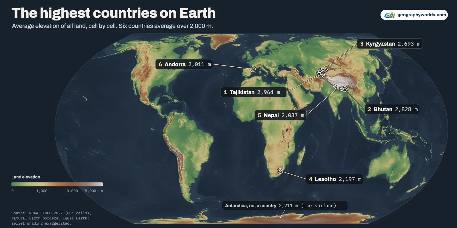
Tajikistan has the highest average elevation of any country: its land sits 2,964 m above sea level on average. Bhutan comes second at 2,828 m and Kyrgyzstan third at 2,693 m, followed by Lesotho (2,197 m), Nepal (2,037 m), Andorra (2,011 m), Armenia (1,865 m), China (1,830 m), Afghanistan (1,795 m) and Rwanda (1,706 m). Those are the averages over every 1-arc-minute grid cell of land in NOAA's ETOPO 2022 relief model. Antarctica is not a country, but if it were it would slot in fourth, at 2,211 m.
Six countries average over 2,000 m: five in Central and South Asia, plus Lesotho. We measured all 187 countries big enough for the grid, and for Bhutan and Nepal our figures differ sharply from the CIA World Factbook's; we explain why below.
Tajikistan, Bhutan and Kyrgyzstan: the roof of the world
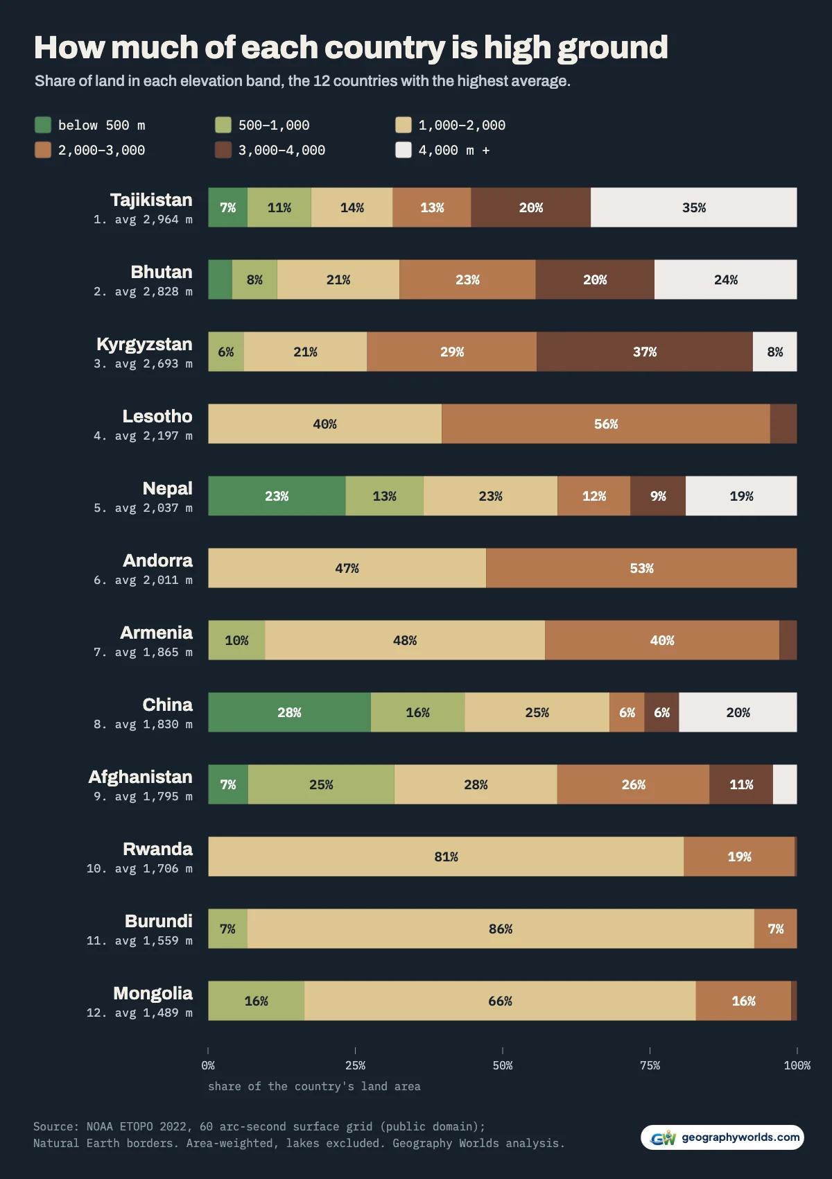
Tajikistan wins because of the Pamir. 55% of the country lies above 3,000 m and 35% above 4,000 m, more than any other country on either count. Its east is a high, dry plateau, and broad land held at height lifts an average far more than a few tall summits. The lowest cell in the country, on the Syr Darya in the north, is at 285 m; the Factbook gives the river's lowest point as 300 m.
Bhutan's land is spread almost evenly from 110 m on the Indian border to nearly 7,000 m on the Tibetan one; only 12% lies below 1,000 m. That puts Bhutan 136 m behind Tajikistan. Natural Earth's Bhutan (40,488 km²) is about 5% larger than official figures, but on the OCHA boundary (38,830 km²) it still averages 2,738 m, above Kyrgyzstan on every line tested. Kyrgyzstan, third, is the most uniformly high of the three: 94% of it lies above 1,000 m, because the Tian Shan fills almost the whole country, valleys included.
| Rank | Country | Average elevation (m) | Land above 2,000 m | Land above 3,000 m | Highest cell (m) | Factbook mean (m) |
|---|---|---|---|---|---|---|
| 1 | Tajikistan | 2,964 | 69% | 55% | 6,848 | 3,186 |
| 2 | Bhutan | 2,828 | 68% | 44% | 6,991 | 2,220 |
| 3 | Kyrgyzstan | 2,693 | 73% | 44% | 6,686 | 2,988 |
| 4 | Lesotho | 2,197 | 60% | 5% | 3,348 | 2,161 |
| 5 | Nepal | 2,037 | 41% | 28% | 7,712 | 2,565 |
| 6 | Andorra | 2,011 | 53% | 0% | 2,677 | 1,996 |
| 7 | Armenia | 1,865 | 43% | 3% | 3,700 | 1,792 |
| 8 | China | 1,830 | 32% | 26% | 8,157 | 1,840 |
| 9 | Afghanistan | 1,795 | 41% | 15% | 6,481 | 1,884 |
| 10 | Rwanda | 1,706 | 19% | 0% | 3,997 | 1,598 |
| 11 | Burundi | 1,559 | 7% | 0% | 2,527 | 1,504 |
| 12 | Mongolia | 1,489 | 17% | 1% | 4,000 | 1,528 |
| 13 | Peru | 1,458 | 31% | 24% | 6,144 | 1,555 |
| 14 | Chile | 1,333 | 25% | 15% | 6,416 | 1,871 |
| 15 | Switzerland | 1,314 | 23% | 2% | 4,111 | 1,350 |
Each "cell" value is the average of a 1.85 km square, so the highest cells sit below the true summits (Nepal's is 7,712 m) and the lowest sit above the true low points.

Nepal, Andorra and China: tall, but with a floor near the plains
Nepal holds the world's highest summit yet ranks fifth, because of the Terai, the strip of Ganges plain along its southern border: 37% of Nepal is below 1,000 m, and the lowest cell is 59 m. In the band chart above it is the green left end of Nepal's bar, while 19% of the country lies above 4,000 m. Average the two and Nepal ends up at 2,037 m, only 26 m ahead of Andorra. Treat fifth and sixth as a tie.
China is eighth at 1,830 m. About a quarter of the country, 26%, lies above 3,000 m, almost all of it on the Tibetan Plateau, but the plains of the east pull its average down.
How the averages were measured
We used ETOPO 2022, NOAA's public-domain global relief model, at 60 arc-seconds: a grid of 21,600 by 10,800 cells, each about 1.85 km from north to south. Each cell went to a country using Natural Earth's 1:10m borders, and averages were weighted by each cell's true area. Lakes were left out, because ETOPO maps lake beds.
Below-sea-level cells needed rules. A below-zero cell within 2 cells of the sea is usually part sea, so we dropped it, along with any cell below the Factbook's Dead Sea level of -431 m; no grid cell of dry land is lower. Other below-zero cells count as land, such as the Dutch polders. Lakes too small for the lake layer stay in at their bed height, which nudges a few lake-rich countries down slightly.
Borders follow Natural Earth's lines of control, with a few changes. Crimea is counted with Ukraine, Somaliland with Somalia and Northern Cyprus with Cyprus. France's overseas departments, the Caribbean Netherlands and Norway's Bouvet Island are left out, so that each average describes the country's main territory. Kashmir is split along the lines of control, and the disputed Siachen Glacier area, which averages 5,438 m, is counted for nobody.
The grid cannot measure microstates or atolls, so we list the 10 countries with fewer than 100 cells in the CSV, unranked: Seychelles, Saint Kitts and Nevis, Liechtenstein, San Marino, Marshall Islands, Monaco, Maldives, Nauru, Tuvalu, Vatican. Andorra, at 178 cells, is ranked: small, but with no coast.
Why our Bhutan and Nepal differ from the Factbook
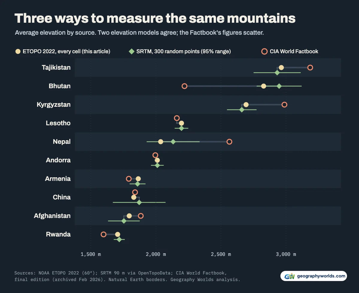
The best-known list of average elevations comes from the CIA World Factbook, which the CIA stopped publishing in February 2026. Its final elevation listing also puts Tajikistan first, at 3,186 m. For most countries it agrees with us: across the 161 countries that appear in both, the median difference is 30 m, and 130 are within 100 m.
The exceptions are large. The Factbook has Bhutan at 2,220 m, 608 m below our figure, and Nepal at 2,565 m, 528 m above it. India is 160 m in the Factbook against our 566 m, and Chile 1,871 m against our 1,333 m. The Factbook never explained its method. Widely quoted figures of about 3,280 m for Bhutan and 3,265 m for Nepal match neither source and we could not trace them.
To test our own numbers, we drew 300 random points spread evenly across each of 12 countries and looked up their heights in a different dataset, NASA's SRTM radar survey at 90 m, through the OpenTopoData service. Every sample landed within 119 m of our value, and for the ten mountain countries inside the sample's own 95% margin of error. Bhutan came out at 2,947 m (± 173 m) and Nepal at 2,133 m (± 203 m), which confirms that Bhutan sits well above Nepal and rules out the Factbook's figures for both. A sample this size cannot by itself tell Tajikistan (2,932 m, ± 181 m) from Bhutan; that order rests on the full grid, where the gap is 136 m.
Lesotho, the country with no lowlands
Lesotho is fourth by average, at 2,197 m, but it holds a record no other country comes close to. Its lowest grid cell is 1,412 m above sea level, the highest low point of any country by a wide margin; the next is Andorra (1,040 m). The Factbook gives Lesotho's true lowest point as 1,400 m, where the Makhaleng River meets the Orange on the South African border. Our cell is a little higher because it also averages in the valley sides.
The same averaging explains the runner-up. Andorra's lowest cell is 1,040 m, but its true lowest point, where the Runer river leaves the country, is 840 m; the deep, narrow valley is simply too small for the grid. Lesotho is the one country lying wholly above 1,000 m by any measure. 60% of it is above 2,000 m but only 5% above 3,000 m: a high tableland, not a range of peaks.

Antarctica and Greenland, if ice sheets counted
Measured at the top of the ice, Antarctica averages 2,211 m, which would rank it fourth. The Factbook rounds it to 2,300 m. An independent check comes from Bedmap2 whose mean ice thickness and mean bed height for the grounded ice sheet add up to 2,209 m. The rock beneath averages only 82 m above sea level in ETOPO's bed layer (Bedmap2: 82.8 m), and 45.0% of it lies below sea level (Bedmap2: 44.7%). Antarctica's height is mostly ice. Several countries claim slices of it; see who claims which part of Antarctica.
Greenland, a territory of Denmark, averages 1,812 m at the ice surface, which would put it between China and Afghanistan. Its bedrock averages 421 m, and 20% of the bed under the island lies below sea level.
The bottom of the list: the Bahamas, the Netherlands and the Gambia
Among countries with at least 1,000 km² of measured land, the Bahamas is lowest at 4 m and the Netherlands second at 9 m, followed by Gambia (20 m), Bangladesh (24 m), Qatar (26 m), Denmark (31 m), Guinea-Bissau (34 m). The SRTM sample agrees: 5 m for the Bahamas and 8 m for the Netherlands. The Factbook puts the Netherlands at 30 m.
The true lowest is probably the Maldives (Factbook mean: 2 m), whose islands are too small for this grid: it finds only 6 cells of Maldivian land.
The Netherlands also has the largest share of land below sea level: 28.7% of the measured country, or 9,770 km². That is close to the 26% given by the Dutch government's PBL environmental assessment agency, which measures against the national datum on a far finer height model. Azerbaijan is second, with 16.6% of its land below sea level in the Kura lowland by the Caspian. In absolute area the leader is Kazakhstan, with 150,088 km² below sea level around the north-eastern Caspian. Its lowest cell reaches -131 m; the Factbook gives the deepest point, the Qauyndy depression, as -132 m. Russia comes next with 90,419 km². Our guide to countries below sea level covers the deepest of these depressions one by one.
Get the data
You can download the data as a CSV for all 197 countries, with each one's mean, extremes, shares above 1,000, 2,000 and 3,000 m, Factbook value and SRTM sample; to sketch hypsometric profiles of your own pick of countries from those columns, Parity turns the spreadsheet into charts without code.
- NOAA NCEI (2022): ETOPO 2022 15 Arc-Second Global Relief Model, 60 arc-second surface and bedrock GeoTIFFs (doi:10.25921/fd45-gt74): Public domain (US government work). Heights relative to the EGM2008 geoid; the surface grid is the top of the ice, the bed grid the rock beneath it.
- Natural Earth v5.1.2: admin-0 countries and lakes, 1:10m: Public domain. De facto boundaries, with the adjustments listed in the article.
- CIA World Factbook, field listing 'Elevation' (final edition, archived 4 February 2026): Public domain US government work. The Factbook was retired in February 2026; read from the Internet Archive copy.
- OpenTopoData public API, SRTM 90 m (NASA Shuttle Radar Topography Mission): Used for an independent check: 300 random points per country, spread evenly by area. SRTM data are public domain.
- Fretwell et al. (2013), Bedmap2: improved ice bed, surface and thickness datasets for Antarctica, The Cryosphere 7: 375–393: Open access, CC BY 3.0. Table 7 statistics for the grounded ice sheet.
- geoBoundaries ADM0 boundaries for Bhutan and Kyrgyzstan: Border test only. Bhutan: OCHA via HDX (CC BY 3.0 IGO) and Wikimedia Commons (CC BY 3.0); Kyrgyzstan: national ministry via HDX (CC BY 3.0 IGO) and OpenStreetMap (ODbL).
- PBL Netherlands Environmental Assessment Agency: Correction wording flood risks for the Netherlands in IPCC report: 26% of the Netherlands lies below sea level.
For the places where people actually live at altitude, see our list of the highest capital cities in the world, which starts in the Andes rather than the Pamir.