
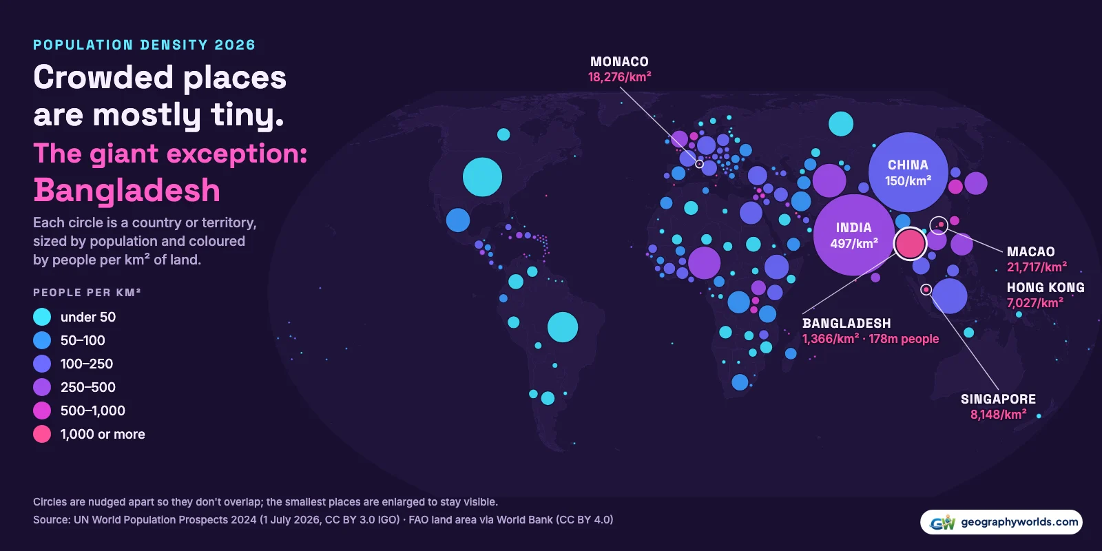
The most densely populated country in the world in 2026 is Monaco, with about 18,276 people per square kilometre of land. Next come Singapore (8,148), Bahrain (2,094), the Maldives (1,784), Malta (1,742) and Bangladesh (1,366). Counting territories as well, China's Macao is denser than any country, at 21,717 per km², and Hong Kong (7,027) sits just behind Singapore. Among the 94 countries and territories with at least 10 million people, Bangladesh is the most crowded by a wide margin. These figures divide the United Nations' population projection for 1 July 2026 (World Population Prospects 2024) by each country's land area as reported by the UN Food and Agriculture Organization, which leaves out lakes and rivers. The world as a whole averages 64 people per km².
Population density is one of the most repeated statistics in geography and one of the most misunderstood. Most of what people believe about it is half right, so this article takes five common beliefs in turn and checks each against the data. The map above sizes every country and territory by its population and colours it by density: the most crowded places are the dots you can barely see.
Myth: Monaco is the most crowded place on Earth
Monaco tops the ranking of sovereign states on any of the area figures in use. Its 38,087 residents share 2.08 km², about four-fifths of a square mile. But it is not the densest place on the UN's list of 237 countries and territories. Macao, a Special Administrative Region of China, fits 723,188 people onto 33.3 km², which works out 19% more crowded than Monaco.

Macao's own statistics service puts the figure slightly lower. The Macao Yearbook 2025 gives the same land area, 33.3 km², but a density of 20,600 per km², and the Statistics and Census Service counted 688,900 residents at the end of 2025, about 5% fewer than the UN projects for mid-2026. Either way, Macao stays ahead of Monaco. Much of Macao is reclaimed land: the Cotai strip between Taipa and Coloane alone covers 6.1 km², according to the same yearbook.
Territories do not usually appear in country rankings, which is why most lists start with Monaco. Here are the densest places that are not sovereign states:
| Territory or area | Population, 2026 | Land area, km² | People per km² |
|---|---|---|---|
| Macao | 723,188 | 33.3 | 21,717 |
| Hong Kong | 7,378,602 | 1,050 | 7,027 |
| Gibraltar | 40,867 | 10.0 | 4,087 |
| Sint Maarten | 44,447 | 34.0 | 1,307 |
| Bermuda | 64,459 | 54.0 | 1,194 |
| Guernsey | 64,610 | 64.0 | 1,010 |
Gibraltar, a British Overseas Territory of 4,087 people per km², would rank third among sovereign states if it were one. Hong Kong is less dense overall than Singapore, but its average takes in 238.66 km² of outlying islands, according to the Hong Kong Yearbook 2024. The same page lists Kwun Tong district at 59,280 people per km², almost three times Macao's average.
Myth: a country's density is one fixed number
Look up Monaco's density in three places and you may get three answers. The UN's World Population Prospects file has its own density column, and for Monaco it says 25,562 per km². That figure implies an area of only 1.49 km², and the UN file does not say which area it divides by. FAO puts Monaco's land at 2.08 km². Monaco's statistics office, IMSEE, gives the same 2.08 km² and a density of 18,472 per km² for the end of 2024, as reproduced in the Italian Trade Agency's country profile. That is within 1% of our 18,276, so this article uses the FAO area throughout.
The other leaders show the same kind of spread. For Singapore we get 8,148 per km², using the UN's projection of 5.9 million people and FAO's 725 km². The Singapore Department of Statistics counted 6.21 million people at the end of June 2026 and publishes a density of 8,332, because the population has grown faster than the UN assumed. For Hong Kong, FAO's land area of 1,050 km² is smaller than the government's 1,114.57 km², so our 7,027 is above the yearbook's official 6,900.
The biggest gap is Bangladesh. The Bangladesh Bureau of Statistics reported a density of 1,119 per km² from its 2022 census, against our 1,366 for 2026. Two things explain it. The census figure (165.16 million people at 1,119 per km²) implies an area of about 147,600 km², the whole country including its rivers, while FAO's 130,170 km² excludes inland water. And the UN figure is for four years later. When two density figures disagree, check the area first.
Myth: only tiny city-states are truly crowded
The top of the sovereign ranking is mostly city-states and small islands. Then comes Bangladesh, in sixth place, with 177.8 million people. It has slightly more land than Greece (130,170 km² against 128,900 km²), but where Greece has 9.9 million people, Bangladesh has 18 times as many. The four densest places on the list, Macao, Monaco, Singapore and Hong Kong, hold 14.0 million people between them, about 8% of Bangladesh's population.
| Rank | Country | Population, 1 July 2026 | Land area, km² | People per km² |
|---|---|---|---|---|
| 1 | Monaco | 38,087 | 2.08 | 18,276 |
| 2 | Singapore | 5,905,748 | 725 | 8,148 |
| 3 | Bahrain | 1,675,572 | 800 | 2,094 |
| 4 | Maldives | 531,517 | 298 | 1,784 |
| 5 | Malta | 549,011 | 315 | 1,742 |
| 6 | Bangladesh | 177,818,044 | 130,170 | 1,366 |
| 7 | Vatican City * | 506 | 0.44 | 1,151 |
| 8 | Palestine * | 5,692,790 | 6,025 | 945 |
| 9 | Barbados | 282,724 | 431 | 656 |
| 10 | Mauritius | 1,265,059 | 2,000 | 633 |
| 11 | Rwanda | 14,889,693 | 23,763 | 627 |
| 12 | Lebanon | 5,897,467 | 10,230 | 576 |
| 13 | Nauru | 12,101 | 21.0 | 576 |
| 14 | Burundi | 14,729,157 | 25,680 | 574 |
| 15 | San Marino | 33,605 | 61.2 | 549 |
| 16 | Netherlands | 18,448,775 | 33,670 | 548 |
| 17 | South Korea | 51,600,388 | 97,600 | 529 |
| 18 | India | 1,476,625,576 | 2,973,190 | 497 |
| 19 | Comoros | 899,010 | 1,870 | 481 |
| 20 | Israel | 9,647,689 | 21,640 | 446 |
Only seven sovereign states top 1,000 people per km²: Monaco, Singapore, Bahrain, the Maldives, Malta, Bangladesh and Vatican City, whose 506 residents on 0.44 km² come to 1,151 per km². Bangladesh is the only one of them with more than 10 million people; the next most populous, Singapore, has 5.9 million. Across all 13 countries and territories above that line, 194.8 million people live at more than 1,000 per km², 2.3% of humanity, and 91% of them are Bangladeshis.

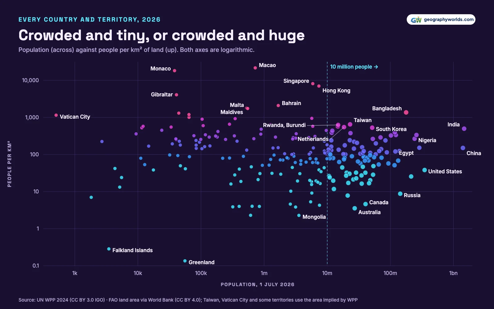
That makes Bangladesh the real outlier in the data. On the scatter chart below, it is the lone point in the upper right, a country of more than 100 million at a density otherwise reached only by islands and city-states. Our guide to the population of Bangladesh covers how that population is spread across its divisions.
Myth: India and China are the world's most crowded giants
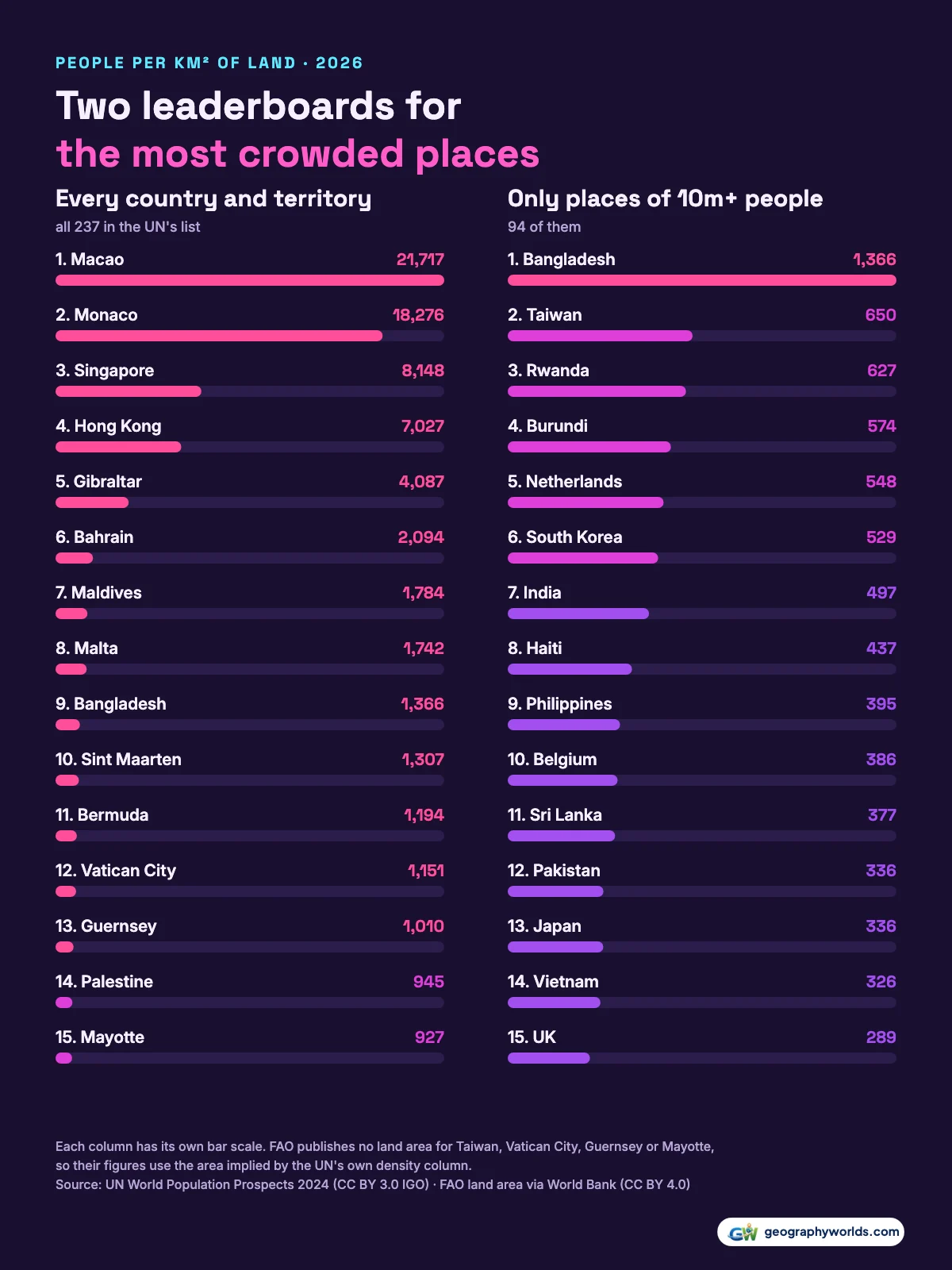
India and China are the two most populous countries, with 1.48 billion and 1.41 billion people in 2026, and they are often assumed to be the most crowded too. Only one of them is near the top. India has 497 people per km², seventh among the places of 10 million or more. China has 150, less than a third of India's density. Bangladesh is 2.8 times as dense as India.
Second among the large places is Taiwan, at 650 per km², with 23.0 million people. FAO publishes no land area for Taiwan, so that figure is the UN's own density column, which implies an area of 35,410 km². Taiwan's Interior Ministry counted 23,299,132 people at the end of 2025, close to the UN's number.
Rwanda (627) and Burundi (574), neighbours in East Africa, come next. Their figures rest on projections: Rwanda's 2022 census counted 13,246,394 people, below the UN's own estimate of 13.7 million for that year, so its 2026 density of 627 may be on the high side. The Netherlands (548) is the densest large country in Europe and South Korea (529) the densest in East Asia after Taiwan. Japan, often pictured as packed, comes in at 336. The United States averages 38, Russia 9, Canada 5 and Australia 4.
Myth: a low average means there is plenty of room
Egypt has 120.1 million people and an average of just 121 per km², below the Philippines, Vietnam or the United Kingdom. The average is misleading. According to FAO, only 3.3% of Egypt's land is arable. Measured against that farmland, Egypt has 3,668 people per km², more than Bangladesh's 2,257, where 61% of the land is arable.
Arable land is not the same as the land people live on, and FAO's definition leaves out orchards and plantations, so this is a rough lens rather than a ranking. But it shows why a national average says little about how crowded a country feels. Within Bangladesh, the 2022 census found Dhaka South City Corporation at 39,353 people per km². Cities are where density becomes extreme, and our list of the most densely populated cities picks up at that scale.
How these figures were calculated
Population is the UN Population Division's medium-variant projection for 1 July 2026, from World Population Prospects 2024, which estimates to 2023 and projects after that. Land area is FAO's latest figure, published by the World Bank (2024 for almost every country), which excludes inland water. Density is one divided by the other. FAO has no area for 22 of the 237 places, among them Taiwan, Kosovo, Western Sahara, French Guiana, Réunion, Guadeloupe, Martinique, the Falkland Islands, Vatican City, Guernsey and Mayotte; for those we use the area implied by the UN's own density column, and the CSV marks which is which.
Sovereign states here are the 195 UN members and observer states, including the Holy See and Palestine. Taiwan, Kosovo and Western Sahara are counted with the territories because they are not UN members, not as a judgment on their status. You can download the data as a CSV, with every place's population, land area, density, rank, area source and arable land.
Sources:
- UN DESA Population Division, World Population Prospects 2024 (Demographic Indicators, medium variant, CSV): Total population on 1 July 2026 (medium-variant projection) and the PopDensity column. © United Nations, CC BY 3.0 IGO.
- World Bank, Land area (sq. km), AG.LND.TOTL.K2, from FAOSTAT: Latest year available (2024 for almost every country). Excludes inland water. CC BY 4.0.
- World Bank, Arable land (hectares), AG.LND.ARBL.HA, from FAO: Latest year available (2024). CC BY 4.0.
- Natural Earth country boundaries via world-atlas (1:50m): Public domain. Used to place the circles on the map only.
The emptiest corners of the world tell the other half of this story, from Mongolia's 2.3 people per km² to Greenland's 0.14, and they are ranked in our guide to the countries with the lowest population density.