
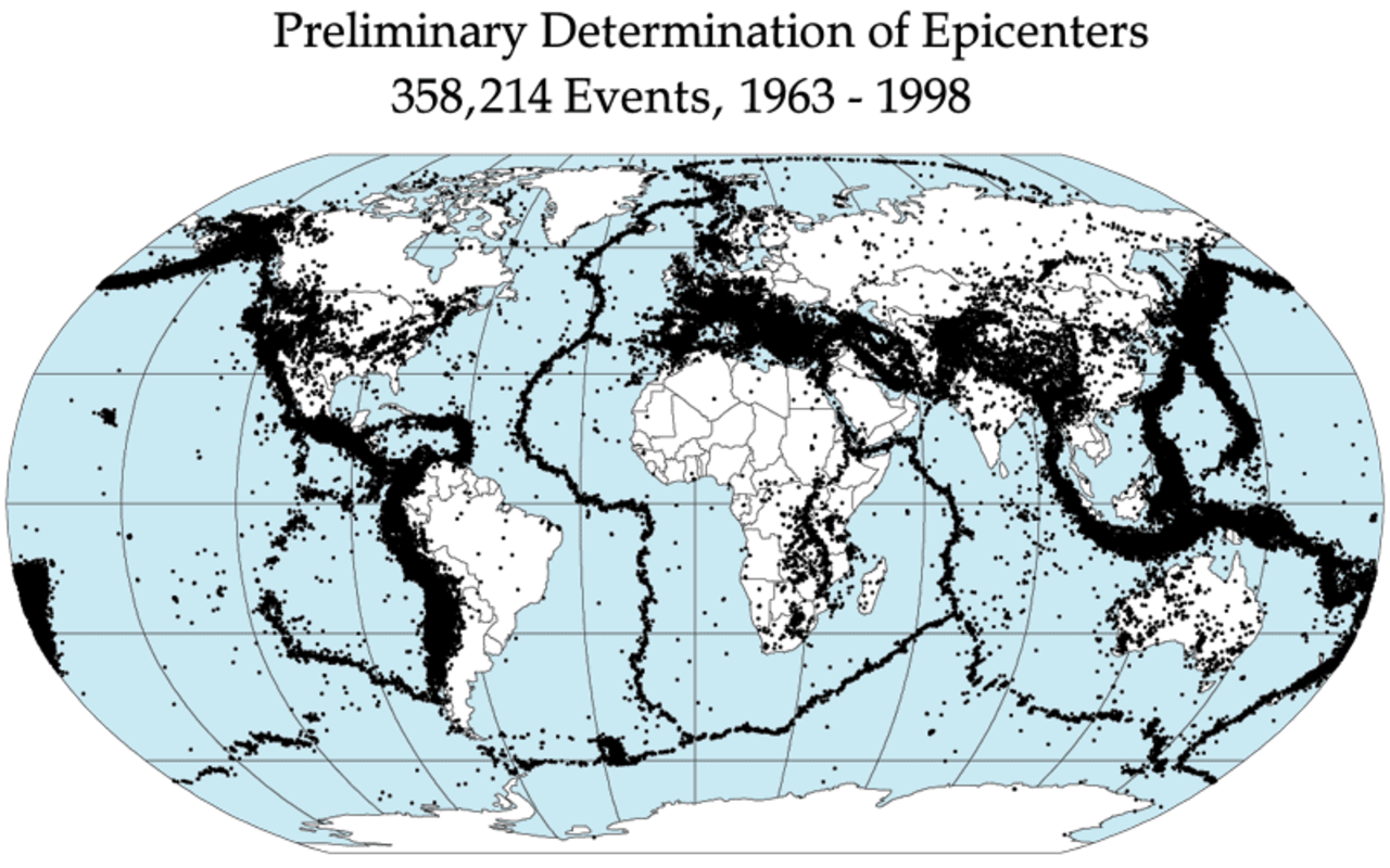
The world's major earthquake zones follow tectonic plate boundaries. The three most seismically active zones are: the Ring of Fire (Pacific Rim), the Alpide Belt (from Mediterranean through Himalayas to Indonesia), and the Mid-Atlantic Ridge. About 80% of earthquakes occur in the Ring of Fire, 15% in the Alpide Belt, and 5% elsewhere.
Introduction
Earthquakes happen when stress accumulated along faults in the Earth's crust is suddenly released, sending seismic waves through the ground. While small earthquakes occur constantly (about 500,000 detectable per year), only about 100 cause damage and roughly 20 are major (magnitude 7.0+). Understanding where and why earthquakes happen is essential for protecting the billions of people who live in seismic zones.

The Ring of Fire
- Location: 40,000 km horseshoe around the Pacific Ocean
- Countries: Chile, Peru, Mexico, USA (West Coast, Alaska), Japan, Philippines, Indonesia, New Zealand
- Earthquake Share: About 80% of the world's earthquakes and 90% of the largest ones
- Cause: Subduction of oceanic plates beneath continental plates
- Notable Quakes: 2011 Tohoku (Japan, M9.1), 1960 Valdivia (Chile, M9.5 — strongest ever recorded)
The Ring of Fire generates so many earthquakes because it is lined with subduction zones — places where dense oceanic plates dive beneath lighter continental plates. This process creates enormous friction and pressure, which is periodically released as earthquakes. The same process also creates the Ring of Fire's 450+ active volcanoes.
Japan, sitting at the junction of four tectonic plates, experiences about 1,500 earthquakes per year that are strong enough to be felt. The country has invested more in earthquake engineering and early warning systems than any other nation. Japan's earthquake early warning system can give residents in distant cities up to a minute of warning before strong shaking arrives.
The Alpide Belt
- Location: From Mediterranean through Middle East, Himalayas, to Indonesia
- Countries: Italy, Greece, Turkey, Iran, Afghanistan, Pakistan, India, Nepal, Myanmar
- Earthquake Share: About 15% of the world's earthquakes
- Cause: Collision of the African, Arabian, and Indian plates with the Eurasian plate
- Notable Quakes: 2023 Turkey-Syria (M7.8, 59,000+ deaths), 2005 Kashmir (M7.6, 87,000 deaths)
The Alpide Belt is created by the collision of the African, Arabian, and Indian tectonic plates with the massive Eurasian plate. This collision zone has built the Alps, Carpathians, Caucasus, Zagros, and Himalaya mountain ranges — and continues to produce devastating earthquakes.
Iran is one of the most earthquake-prone countries in the world, with a long history of catastrophic tremors. The 2003 Bam earthquake killed over 26,000 people when the ancient mud-brick city collapsed. Iran averages one major earthquake per year, yet much of its building stock remains poorly engineered for seismic resistance.
The Mid-Atlantic Ridge & Other Zones
- Mid-Atlantic Ridge: Divergent boundary running down the center of the Atlantic Ocean
- East African Rift: Continent splitting apart; creates earthquakes and volcanoes
- Intraplate Earthquakes: Rare but damaging; 1811-12 New Madrid (Missouri) quakes felt across eastern US
- Mid-Ocean Ridges: Most earthquakes here are small and deep underwater
- Stable Regions: Continental interiors like central Australia, Sahara, and Canadian Shield are seismically quiet
The Mid-Atlantic Ridge produces frequent earthquakes but they are mostly small and occur deep underwater, posing little threat to people. Iceland is the notable exception — it sits directly on the ridge and experiences frequent earthquakes and volcanic eruptions as the North American and Eurasian plates pull apart.
Intraplate earthquakes — those occurring far from plate boundaries — are rare but can be devastating because infrastructure in these areas is not designed for seismic forces. The 1811-1812 New Madrid earthquakes in Missouri were among the most powerful ever recorded in North America, ringing church bells in Boston 1,600 km away. A similar event today would affect tens of millions of people in Memphis, St. Louis, and Nashville.
Measuring & Predicting Earthquakes
- Moment Magnitude Scale: Replaced Richter scale; each whole number = 31.6x more energy
- Seismographs: Global network of 26,000+ stations detects and locates earthquakes
- P-Waves & S-Waves: P-waves (fast, compressional) arrive before S-waves (slow, destructive)
- Early Warning: Japan's system provides seconds to a minute of warning before strong shaking
- Prediction: Scientists cannot predict when earthquakes will occur — only where they are likely
The Moment Magnitude Scale (Mw) measures the total energy released by an earthquake. Each whole number increase represents about 31.6 times more energy. A magnitude 7.0 earthquake releases about 1,000 times more energy than a magnitude 5.0. The largest earthquake ever recorded was the 1960 Valdivia, Chile earthquake at magnitude 9.5.
Despite decades of research, scientists cannot predict when or where the next earthquake will strike with any useful precision. Instead, seismologists create probabilistic hazard maps showing the likelihood and expected intensity of shaking in different areas over timeframes of decades to centuries. These maps are the basis for building codes in seismic zones.
Most Earthquake-Prone Countries
- Japan: ~1,500 felt earthquakes/year; world leader in earthquake engineering
- Indonesia: On 3 major plates; 2004 tsunami was triggered by M9.1 quake
- China: 1556 Shaanxi earthquake killed ~830,000; deadliest in history
- Iran: Averages one major earthquake per year across the Zagros-Alborz fault system
- Chile: Most seismically active in South America; M9.5 in 1960
- Turkey: Anatolian fault system; devastating 2023 earthquakes
- Nepal: 2015 M7.8 earthquake killed ~9,000; Himalayas still rising
- USA: San Andreas Fault (California), Cascadia Subduction Zone (Pacific NW), Alaska
The United States has significant earthquake risk along its western edge. California's San Andreas Fault is perhaps the world's most famous fault line, and scientists estimate a 60% probability of a magnitude 6.7+ earthquake in the San Francisco Bay Area by 2043. The Cascadia Subduction Zone in the Pacific Northwest is capable of producing a magnitude 9.0+ earthquake and tsunami similar to the 2011 Japan disaster.
Key Facts
- About 80% of earthquakes occur in the Ring of Fire, 15% in the Alpide Belt, and 5% elsewhere.
- Roughly 500,000 detectable earthquakes occur each year; about 100 cause damage.
- The largest recorded earthquake was the 1960 Valdivia, Chile quake at magnitude 9.5.
- Each whole number on the magnitude scale represents about 31.6 times more energy.
- Scientists cannot predict when earthquakes will occur — only where they are likely.
Fun Facts
- Moonquakes — seismic events on the Moon — were first detected by instruments left by Apollo astronauts and can last over 10 minutes.
- The 2011 Tohoku earthquake in Japan shifted the Earth's axis by about 17 cm and sped up the planet's rotation by 1.8 microseconds.
- Animals may detect earthquakes before humans — reports of unusual behavior in dogs, snakes, and fish before quakes date back thousands of years, though scientific evidence is inconclusive.
- Oklahoma became one of the most seismically active states in the US due to wastewater injection from oil and gas operations — an example of human-induced earthquakes.
Final Thoughts
Earthquake zones are among the most geographically significant features on our planet, marking the boundaries where tectonic plates interact. While we cannot prevent or predict earthquakes, understanding where they occur and why allows communities to prepare through better building codes, early warning systems, and emergency planning.
Test Your Knowledge!
Think you know your geography? Try our interactive quiz!
Play Geography Games →