

Fiji is an archipelago in the South Pacific Ocean, about 1,770 km north of New Zealand, made up of 332 islands and 522 smaller islets, of which about 106 are permanently inhabited. Its land area is only about 18,274 km², but its exclusive economic zone covers roughly 1.28 million km² of ocean, some seventy times as much. Two large volcanic islands, Viti Levu and Vanua Levu, hold close to 90 percent of the land; the rest is scattered across the Yasawa, Mamanuca, Lomaiviti, Kadavu and Lau groups, plus the outlying dependency of Rotuma. Both main islands have rugged, forested interiors, a rainy windward southeast and a drier leeward west. The highest point is Mount Tomanivi, 1,324 m (4,344 ft), in the highlands of Viti Levu, and the main rivers, the Rewa, Sigatoka, Navua and Ba, all rise on that same central upland. The 2017 census counted 884,887 people.
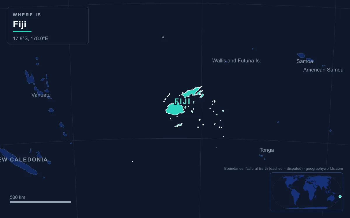
The islands sit on the northeast corner of the Indo-Australian Plate, on the North Fiji Basin microplate between the North Fiji Fracture Zone to the north and the Hunter Fracture Zone to the south, part of the Pacific Ring of Fire. That setting explains the volcanic peaks and the shallow earthquakes, while coral reefs have grown up around almost every coast.
The Nadrau Plateau and Mount Tomanivi, the Roof of Viti Levu
Viti Levu, "Great Fiji", measures about 146 km east to west and 106 km north to south, with an area of 10,389 km², about 57 percent of the country. A mountain range running north to south splits it into two roughly equal halves. At its centre stands Mount Tomanivi, known in colonial times as Mount Victoria, an extinct volcano in the northern highlands.
Tomanivi belongs to the Plio-Pleistocene Mba group of volcanic rocks, porphyritic basalt flows that also build the neighbouring peaks of Koroyanitu (about 1,195 m), Monavatu and Malua. Its slopes carry much of Fiji's highest montane forest, and a 17,500-hectare block of reserves around the mountain, the Greater Tomaniivi Important Bird Area, is seen as the best hope for the critically endangered red-throated lorikeet. The surrounding upland, the Nadrau Plateau, is the island's watershed: the Rewa, Navua, Sigatoka and Ba all have their headwaters here, fanning out from the centre in different directions.
West of the divide lie the Nausori Highlands, grass-covered ridges and dry-zone mountain forest above Nadi, dotted with small villages such as Navala. The interior as a whole is thinly settled. More than half of all Fijians live on the coasts, because the rough terrain inland makes roads and farming hard.

The Rewa Delta and the Rain-Soaked Southeast
The southeastern side of Viti Levu faces the trade winds, and the mountains wring the moisture out of them. Rainfall on windward slopes reaches about 3,000 mm a year, and Suva, the capital, averages roughly that amount with no true dry season; even its driest month, July, gets about 125 mm. This is where Fiji's tropical moist forests grow.
All that water feeds the Rewa River, the longest and widest river in Fiji. It forms where the Wainibuka and Wainimala join, collects the Waidina and Waimanu, and runs about 170 km from its farthest sources to Laucala Bay near Suva. Its catchment of 3,092 km² takes in the wettest third of the island, with close to 3,900 mm of rain a year, so the river carries an average of about 250 m³ of water a second, and cyclones can send destructive floods down it. Near the sea the Rewa spreads into a delta of about 240 km² of alluvial soil, mangroves and seagrass, where rice and vegetables are grown and dairy cattle are raised. Small boats can navigate some 80 km upstream, and at Nausori a new 425 m bridge now crosses beside the old one.
Farther west on the same coast, the 65 km Navua River rises on Mount Gordon and cuts a narrow gorge through the central highlands. The Upper Navua Conservation Area there was listed as a Ramsar wetland of international importance on 11 April 2006.
The Burning West: Sigatoka Valley and the Sugar Coast
Cross the divide and the island changes character. Western Viti Levu lies in the rain shadow of the central range, and people in Suva call it "the burning west". Nadi, home of the international airport, has a short dry season in July and August and far less rain than the capital. The drier climate supports Fiji's tropical dry forests and, more importantly for the economy, the sugar-cane farms of the western lowlands around Nadi, Lautoka and Ba. Fiji's largest cattle ranch, 7,000 head on 70 km², is at Yaqara between Tavua and Rakiraki on the north coast.
The Sigatoka River rises on the west side of Tomanivi and flows about 120 km to the south coast between the central and western ranges. Historically it was the main route from the coast into the interior, and the Nadarivatu Dam was completed in its headwaters in 2012. At its mouth, about 3 km west of Sigatoka town, erosion from the hinterland has piled up the Sigatoka Sand Dunes: a 650-hectare field of parabolic dunes 20 to 60 m high. In July 1989 they became Fiji's first national park, and excavations there have turned up pottery more than 2,600 years old and one of the largest burial sites in the Pacific.
Vanua Levu, Taveuni and the Somosomo Strait
Vanua Levu, "Big Land", lies 64 km northeast of Viti Levu. At 5,587 km² it is the second-largest island and holds just over 30 percent of Fiji's land but only about 15 percent of its people, around 160,000 in 2022. The island is shaped like a long, thin triangle, about 180 km long and 30 to 50 km wide, pointing northeast to Udu Point. A long peninsula juts into the Koro Sea from its southeast side, and in the northeast the coast wraps around the broad inlet of Natewa Bay. The 180th meridian touches the island's northeastern tip.
A rugged range runs along the island near its southern, windward coast. Its highest peak is Mount Batini, also called Nasorolevu, at about 1,111 m. As on Viti Levu, the north lies in the lee: it is dry eight months of the year, and sugar cane dominates around Labasa, which stands on a delta built by the Labasa, Wailevu and Qawa rivers. Offshore, the Cakaulevu Reef runs as a long barrier reef along the northern shore.
Across the 6.5 km Somosomo Strait lies Taveuni, the third-largest island at 434 km². It is the exposed top of a single elongated shield volcano, 42 km long and 10 to 14 km wide, and about 150 volcanic cones dot its spine. They include Uluigalau, Fiji's second-highest peak at 1,241 m, and Des Vœux Peak at 1,195 m. At least 58 eruptions have occurred since people first settled the island between 950 and 750 BC; the most recent lava flow reached the southern tip around 1550. Lake Tagimaucia fills a crater at about 800 m, and the Rainbow Reef on the strait side is known worldwide for its soft corals.
Kadavu and the Great Astrolabe Reef
About 88 km south of Suva lies Kadavu, the fourth-largest island at 411 km². It is 60 km long but in places only 365 m wide, and the Namalata Isthmus nearly slices it in two, separating Namalata Bay on the north coast from Galoa Harbour on the south. The terrain is steep and mountainous, rising in the west to Nabukelevu, or Mount Washington, at 805 m. Few roads cross it, and about 75 percent of its original rainforest still stands, home to four bird species found nowhere else, including the Kadavu honeyeater and the crimson shining-parrot.
Wrapped around the south and east of the island and then running north past Ono is the Great Astrolabe Reef, one of the largest barrier reefs in the world, named after the French exploring ship Astrolabe. Channels such as Naiqoro Passage lead from very deep water into sheltered lagoons, making the reef a breeding ground for marlin, tuna, sharks and giant trevally. Water temperatures run from about 25 to 32 °C, and visibility often reaches 25 m.

The Yasawa, Lomaiviti and Lau Chains
The smaller island groups together cover only about 12.5 percent of Fiji's land and hold roughly 16 percent of its people. Off the west coast, the Mamanuca Group lies just outside Nadi, and beyond it the Yasawa Group, about 20 volcanic islands with a total area of roughly 135 km², stretches northeast for more than 80 km from a point 40 km northwest of Lautoka. The Yasawas are steep, with peaks of 250 to 600 m. William Bligh was the first European to sight them in 1789, after the mutiny on the Bounty, and they stayed closed to land-based tourism until 1987.
East of Viti Levu, the Lomaiviti Group lies just off Suva. Its island of Ovalau holds Levuka, the former capital and the only sizeable town on any of the smaller islands. Beyond the Koro Sea, the Lau Group spreads toward Tonga, from which the Lakeba Passage separates it: about 60 islands and islets, 30 of them inhabited, with a combined land area of about 487 km². Geology changes along the chain. Most of the northern Lau islands are high volcanic islands, while those in the south are mostly low carbonate islands built from limestone. Fiji's easternmost point, Vatoa, is in this group; James Cook reached it in 1774.
Rotuma, Conway Reef and the Pacific Beyond
Two outliers stretch the country's reach. Rotuma, a shield volcano about 13 km long lying some 646 km north of Suva, covers about 44 km² and is culturally Polynesian; it is a self-governing dependency of Fiji, and the 2017 census counted 1,583 residents, though some 10,000 Rotumans live elsewhere in Fiji. About 450 km southwest of the main islands lies Ceva-i-Ra, or Conway Reef, an uninhabited coral atoll and sand cay that forms Fiji's southernmost point.
These scattered specks are what give Fiji its vast ocean territory, and the whole archipelago shares the same exposure. Tropical cyclones are the great hazard. Cyclone Winston in February 2016 was the most intense on record in the Southern Hemisphere and caused widespread destruction across Fiji, and Cyclone Harold, a Category 5 storm, passed close south of Viti Levu and over the Kadavu group in April 2020. Sea-level rise threatens low deltas like the Rewa's and the coral islands of southern Lau. For the capital's own setting on the rainy Suva Peninsula, see our guide to Suva, Fiji's capital; for where the islands sit among their neighbours, read the Pacific island nations, and to settle a common question, whether Fiji belongs to Asia or Oceania.