
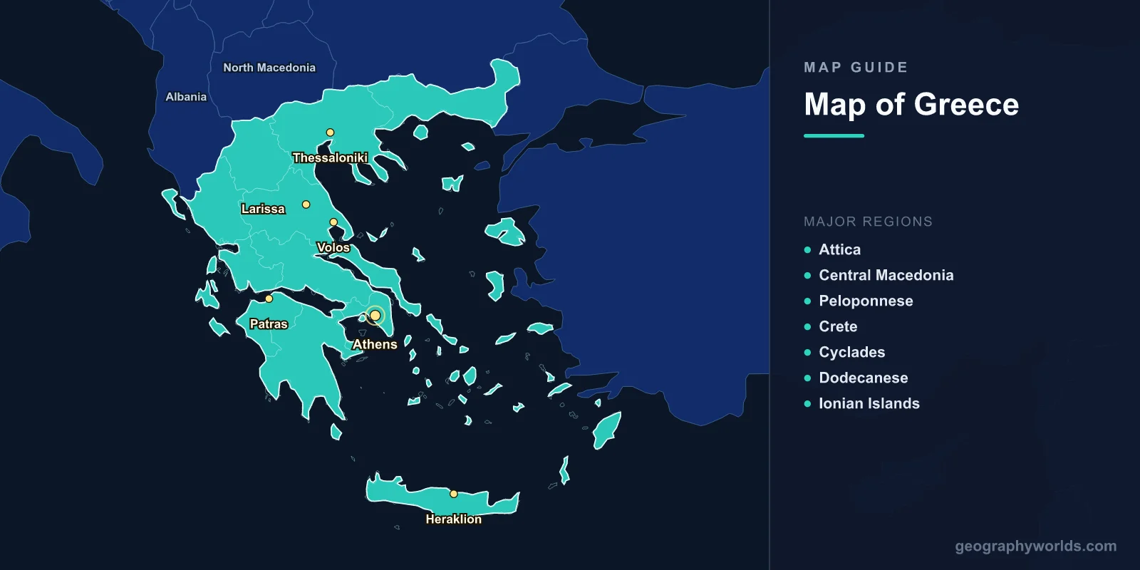
Greece is located in southeastern Europe at the southern tip of the Balkan Peninsula, covering 131,957 km2 (50,949 sq mi) with a population of approximately 10.4 million. The capital is Athens (37.9838°N, 23.7275°E). A map of Greece shows a heavily indented mainland coastline, the Peloponnese peninsula, and over 6,000 islands scattered across the Aegean, Ionian, and Mediterranean seas, of which about 227 are inhabited.
Introduction
Greece is bordered by Albania, North Macedonia, and Bulgaria to the north, and Turkey to the northeast. Its coastline of nearly 14,000 km is the longest in the Mediterranean basin. About 80% of Greece is mountainous, with Mount Olympus (2,918 m) as the highest peak. The country’s location at the crossroads of Europe, Asia, and Africa gave rise to one of the world’s oldest civilizations.

Geographic Overview
- Area: 131,957 km2 (50,949 sq mi)
- Population: 10.4 million (2024)
- Capital: Athens
- Coordinates: 39.0742°N, 21.8243°E
- Highest Point: Mount Olympus, 2,918 m
- Coastline: ~13,676 km
- Islands: 6,000+ (227 inhabited)
Greece’s terrain is among the most mountainous in Europe, with the Pindus Mountains running through the mainland and significant ranges on Crete, the Peloponnese, and many islands. Lowlands are limited to the plains of Thessaly, the Macedonian plain, and river valleys. The country sits in a seismically active zone, experiencing frequent earthquakes.
Major Regions
- Attica: Athens metropolitan area; 3.8 million; Saronic Gulf coast
- Central Macedonia: Thessaloniki; northern Greece; 1.9 million
- Peloponnese: Southern peninsula; Corinth, Sparta, Olympia; connected by isthmus
- Crete: Largest island; 8,450 km2; Heraklion; Samaria Gorge
- Cyclades: Iconic island chain; Santorini, Mykonos; whitewashed architecture
- Dodecanese: Southeastern islands; Rhodes, Kos; near Turkish coast
- Ionian Islands: Western coast; Corfu, Kefalonia; lush green landscapes
Greece is divided into 13 administrative regions (peripheries) and the autonomous monastic community of Mount Athos. The island groups—Cyclades, Dodecanese, North Aegean, Sporades, Saronic, and Ionian—each have distinct characters shaped by geography, climate, and history. Crete, the largest island, has its own mountain range (the White Mountains) reaching 2,453 m.
Major Cities
- Athens: 664,000 (city), 3.8 million (metro); capital; Attica basin
- Thessaloniki: 325,000; second city; northern Greece; Thermaic Gulf
- Patras: 215,000; western Peloponnese; gateway to Ionian Islands
- Heraklion: 175,000; capital of Crete; near Knossos palace
- Larissa: 170,000; Thessaly plain; agricultural center
- Volos: 145,000; Pagasetic Gulf; gateway to the Pelion peninsula
Athens dominates Greece’s urban landscape, with the metro area housing over a third of the national population. The city sits in a basin surrounded by mountains—Hymettus, Penteli, Parnitha, and Aigaleo. Thessaloniki, Greece’s second city and the capital of Macedonia, is a port city with a history stretching back to 315 BC.
Bodies of Water & Natural Features
- Aegean Sea: Eastern coastline; dotted with thousands of islands
- Ionian Sea: Western coastline; deeper than the Aegean; up to 5,267 m
- Mount Olympus: 2,918 m; home of the Greek gods in mythology
- Samaria Gorge: 16 km; one of Europe’s longest gorges; Crete
- Santorini Caldera: Volcanic crater flooded by the sea; last major eruption ~1600 BC
- Corinth Canal: 6.4 km artificial waterway; cuts through the isthmus
Greece’s position at the convergence of the African and Eurasian tectonic plates creates significant seismic and volcanic activity. The Santorini caldera was formed by one of the largest volcanic eruptions in human history (~1600 BC), which may have contributed to the decline of the Minoan civilization on Crete. Greece has numerous hot springs, a result of its volcanic geology.
Bordering Countries
- Albania: 212 km northwestern border
- North Macedonia: 234 km northern border
- Bulgaria: 472 km northeastern border
- Turkey: 192 km border in Thrace; plus maritime borders in the Aegean
Greece’s strategic position controlling the eastern Mediterranean and the approaches to the Dardanelles has been important since antiquity. The narrow straits between Greek islands and the Turkish coast have been contested for centuries. Greece’s Exclusive Economic Zone in the Mediterranean is one of the largest in Europe due to its vast island territories.
Key Facts
- Greece has over 6,000 islands, making it one of the most island-rich countries in the world.
- About 80% of Greece’s terrain is mountainous.
- Greece has the longest coastline in the Mediterranean at nearly 14,000 km.
- The Corinth Canal is just 24 m wide at its base, carved through solid rock.
- Greece experiences over 20,000 small earthquakes per year due to its tectonic position.
Fun Facts
- Santorini’s eruption around 1600 BC ejected roughly 60 km3 of material—four times more than Krakatoa.
- Mount Athos is an autonomous monastic community of 20 monasteries where women have been banned for over 1,000 years.
- Greece has more archaeological museums per capita than any country in the world.
- The Vikos Gorge in Epirus holds the Guinness record for the world’s deepest gorge relative to its width.
Final Thoughts
Greece’s map reveals a country where land and sea are inseparable—thousands of islands, a coastline longer than most nations’ total borders, and mountains covering four-fifths of the terrain. From the volcanic Cyclades to the forested peaks of the Pindus, understanding Greece’s geography is essential to appreciating its outsized role in world history and culture.
Test Your Geography Knowledge!
Think you know your maps? Try our interactive geography games!
Play Geography Games →