
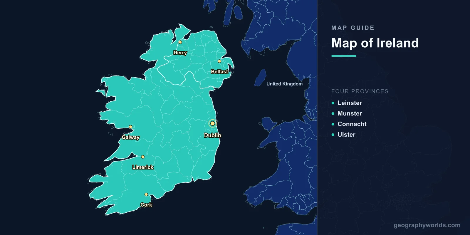
Ireland is the third-largest island in Europe, covering 84,421 km2 (32,595 sq mi) in the North Atlantic Ocean. A map of Ireland shows 32 traditional counties, a low-lying central plain, and a rugged, mountain-fringed Atlantic coastline. The island is politically divided between the Republic of Ireland (26 counties, 70,273 km2, capital Dublin) and Northern Ireland (6 counties, 13,843 km2, part of the United Kingdom), with a combined population of roughly 7 million.
Where Ireland Sits on the Map
Ireland lies off the northwestern edge of continental Europe, separated from Great Britain by the Irish Sea. It is bordered by the Atlantic Ocean to the west and south, the Celtic Sea to the southeast, St George's Channel to the east, and the Irish Sea to the northeast. At its narrowest point, the North Channel between Northern Ireland and Scotland is just 20 km wide. The island's mild, moist climate is shaped by the warm waters of the Gulf Stream, which keep winter temperatures above freezing in most areas and produce the year-round greenery that earned Ireland the nickname "the Emerald Isle."
The Four Provinces and 32 Counties
Ireland's geography is traditionally organised into four historic provinces—Leinster, Munster, Connacht, and Ulster—that date back to the Gaelic kingdoms of early medieval Ireland. These provinces in turn contain the island's 32 counties, which remain the most familiar way people describe where they are from, even though their administrative role has changed over time.
- Leinster (East): 12 counties — Dublin, Wicklow, Wexford, Carlow, Kildare, Meath, Louth, Longford, Westmeath, Offaly, Laois, and Kilkenny. The most urbanised and populous province, anchored by Dublin.
- Munster (South): 6 counties — Cork, Kerry, Limerick, Tipperary, Waterford, and Clare. Home to Ireland's largest county (Cork) and its highest mountains.
- Connacht (West): 5 counties — Galway, Mayo, Sligo, Roscommon, and Leitrim. The most rugged and least densely populated, with the strongest surviving Irish-speaking communities.
- Ulster (North): 9 counties — six (Antrim, Armagh, Down, Fermanagh, Londonderry, and Tyrone) form Northern Ireland within the UK; the remaining three (Donegal, Cavan, and Monaghan) belong to the Republic.
The Republic of Ireland uses 26 counties as the basis of its local government, while Northern Ireland's six historic counties were reorganised into 11 districts in 2015. This split between province and political border is why Ulster is often confused with Northern Ireland—the two are not the same thing.
Geographic Overview
- Area: 84,421 km2 (32,595 sq mi), total island
- Population: ~7.0 million (island total)
- Capital (Republic): Dublin (53.3498°N, 6.2603°W)
- Highest Point: Carrauntoohil, 1,038 m (County Kerry)
- Coastline: ~7,500 km
- Climate: Temperate oceanic; mild winters, cool summers
Ireland's interior is dominated by a broad central lowland plain of limestone, peat bogs, and lakes, ringed by coastal mountains and hills—a shape sometimes compared to a shallow bowl or saucer. This ring of upland is broken in only a few places, most notably along the east coast near Dublin, which is one reason the capital grew where it did. The mountains are modest by global standards: even Carrauntoohil, the highest peak, is barely over 1,000 m.
Major Cities
- Dublin: ~1.4 million (metro); capital of the Republic; east coast on the River Liffey
- Belfast: ~340,000; capital of Northern Ireland; on the River Lagan
- Cork: ~210,000; second city of the Republic; built around one of the world's largest natural harbours
- Limerick: ~100,000; on the Shannon estuary; third-largest city in the Republic
- Galway: ~85,000; Atlantic-facing western city and cultural capital
- Derry/Londonderry: ~85,000; second city of Northern Ireland; on the Foyle estuary
Dublin dominates the east coast and accounts for roughly 40% of the Republic's GDP, making it the clear economic and political centre. Cork's deep natural harbour at the head of Cork Harbour ranks among the largest natural harbours in the world. Galway, facing the Atlantic and the Aran Islands, is one of the Republic's fastest-growing cities and a hub of Irish-language culture.
Rivers, Lakes, and Coastal Features
Water is everywhere on the Irish map. The poorly drained central plain holds countless lakes (loughs) and bogs, while a network of rivers carries rainfall out to the surrounding seas.
- Shannon: The longest river in the British Isles at 360 km; it drains roughly one-fifth of the island before reaching the Atlantic via a wide estuary.
- Lough Neagh: The largest lake in the British Isles at 392 km2, in Northern Ireland; it supplies around 40% of the region's drinking water.
- Cliffs of Moher: Sea cliffs rising 214 m in County Clare, drawing over 1.5 million visitors a year.
- The Burren: A 360 km2 karst limestone landscape in County Clare, unique in Ireland.
- Ring of Kerry: A 179 km scenic route circling the Iveragh Peninsula beneath the Macgillycuddy's Reeks, Ireland's highest mountain range.
- Giant's Causeway: Around 40,000 interlocking basalt columns in County Antrim; a UNESCO World Heritage Site.
The western coast holds some of Europe's most dramatic scenery. The Wild Atlantic Way, a 2,500 km coastal driving route, threads past sea cliffs, offshore islands, and remote beaches from Donegal to West Cork. Inland, Killarney National Park protects Ireland's largest remaining native oak woodland, while the Connemara region in Galway is famed for its bogs, lakes, and mountains.
Climate, Land, and Wildlife
Because the Gulf Stream moderates its weather, Ireland rarely sees extreme heat or hard frost. Rainfall is frequent—especially in the west, where some areas record more than 225 wet days a year—which sustains the lush pasture that defines Irish agriculture. Peatlands are a defining feature: roughly 12,000 km2 of bog covers about 17% of the island, storing carbon and historically providing turf for fuel. Ireland's island isolation also explains its limited wildlife. Famously, the island has no native snakes—it was simply too cold for reptiles to recolonise after the last Ice Age, before rising seas cut Ireland off from Britain and mainland Europe.
Neighbouring Nations
- Great Britain: Across the Irish Sea; just 20 km away at the North Channel near Scotland.
- France: The nearest continental neighbour, reached via the Celtic Sea.
- Iceland: A North Atlantic neighbour about 1,500 km to the northwest.
Ireland's island position has shaped its culture and history for millennia. The same Atlantic location that isolated it also made it a key waypoint for transatlantic travel and the undersea communication cables that once linked Europe and North America.
Key Facts
- Total area: 84,421 km2, the third-largest island in Europe after Great Britain and Iceland
- Counties: 32 traditional counties — 26 in the Republic, 6 in Northern Ireland
- Provinces: Leinster, Munster, Connacht, and Ulster
- Longest river: The Shannon, 360 km
- Largest lake: Lough Neagh, 392 km2
- Highest peak: Carrauntoohil, 1,038 m, County Kerry
- Peatland cover: Roughly 17% of the island
Fun Facts
- Newgrange passage tomb in County Meath predates the Egyptian pyramids by about 500 years.
- The Aran Islands off Galway preserve a traditional Irish-speaking community and ancient stone forts.
- Ireland has no native snakes, a quirk later wrapped into the legend of Saint Patrick.
- Cork Harbour is often cited as one of the largest natural harbours in the world.
Frequently Asked Questions
How many counties are there in Ireland?
There are 32 traditional counties on the island of Ireland. Of these, 26 lie in the Republic of Ireland and 6 in Northern Ireland, which is part of the United Kingdom. The counties are grouped into four historic provinces: Leinster, Munster, Connacht, and Ulster.
What is the difference between Ireland and Northern Ireland?
The Republic of Ireland is an independent sovereign country covering about 70,273 km2 with its capital at Dublin. Northern Ireland is a separate political entity of about 13,843 km2 that forms part of the United Kingdom, with Belfast as its largest city. Both share the same island, which is why a map of "Ireland" usually shows the whole landmass.
What is the longest river and largest lake in Ireland?
The Shannon is the longest river, running 360 km and draining roughly a fifth of the island before reaching the Atlantic. The largest lake is Lough Neagh in Northern Ireland, which at 392 km2 is also the biggest lake in the entire British Isles.
Why is Ireland called the Emerald Isle?
Ireland's mild, wet, Gulf Stream-warmed climate keeps the countryside green throughout the year. Frequent rainfall and rare extremes of temperature produce lush grass and pasture, giving the island its vivid green appearance and the enduring nickname "the Emerald Isle."
Test Your Geography Knowledge!
Think you know your maps? Try our interactive geography games!
Play Geography Games →