
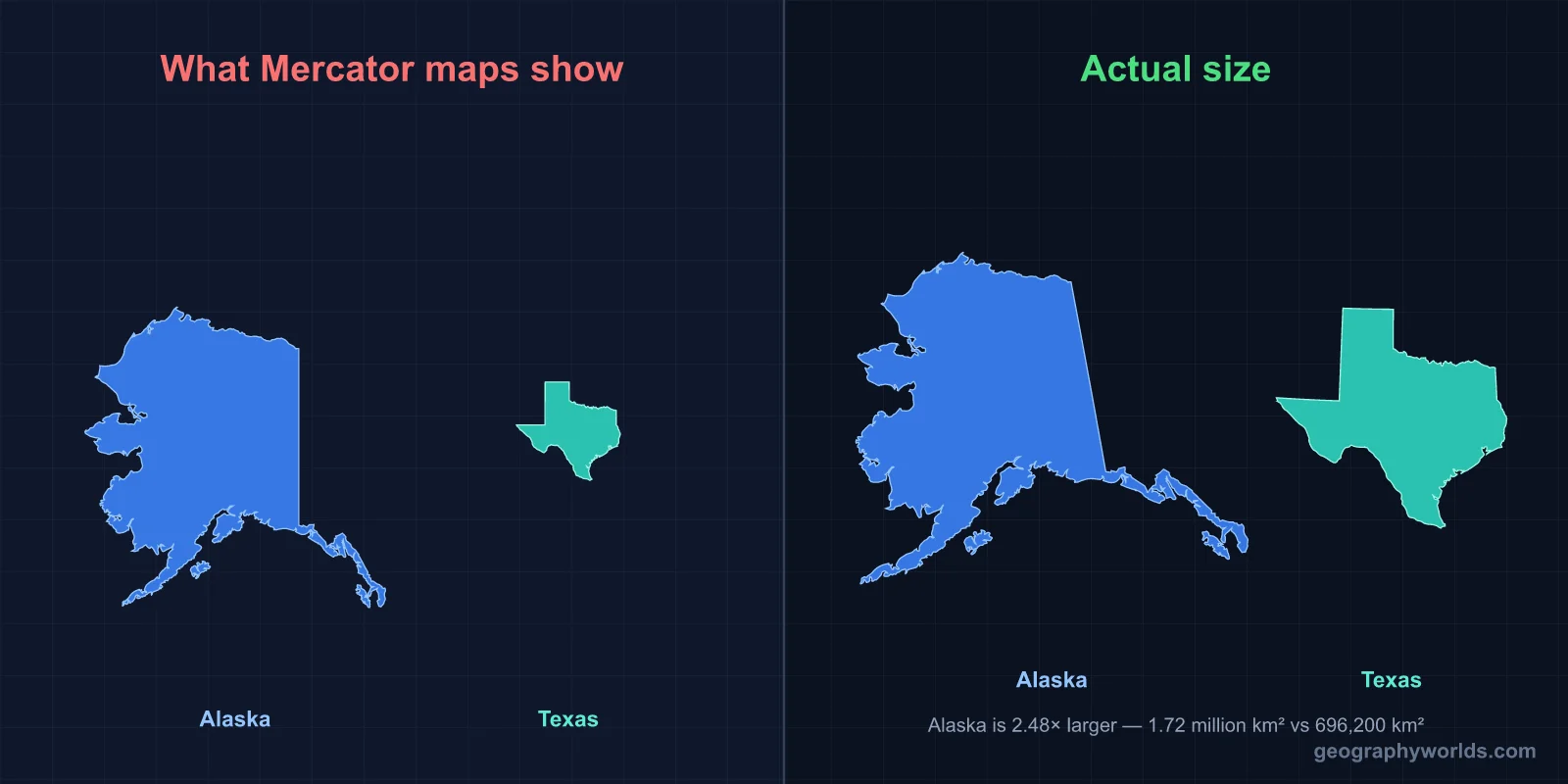
Yes. Alaska is much bigger than Texas. Alaska covers 1,723,337 km² (665,400 sq mi), while Texas covers 696,200 km² (268,597 sq mi). Alaska is about 2.5 times the size of Texas — you could fit Texas inside Alaska and still have enough room left over for California.
The Short Answer
Despite the "everything is bigger in Texas" slogan, Alaska is hands-down the largest US state, and the gap isn't close. Alaska is roughly 2.47× Texas's area. If you took every other US state and shrunk it to Texas size, Alaska would still cover the space of 2.5 of them. Put another way: you could carve Alaska into roughly 425 Rhode Islands, or 21 West Virginias, or — most strikingly — fit Texas + California + Montana inside Alaska's borders.
The Alaska-vs-Texas size question keeps trending because Texas has spent decades building its identity around bigness. Texas was indeed the largest state for 14 years (from 1845 when it joined the Union to 1959 when Alaska joined). But Alaska's admission ended that reign in dramatic fashion.

The Real Numbers
- Alaska total area: 1,723,337 km² (665,400 sq mi)
- Texas total area: 696,200 km² (268,597 sq mi)
- Difference: 1,027,137 km² — roughly the size of Egypt
- Ratio: Alaska is about 2.47× the size of Texas
To put Alaska in global perspective, if it were a country it would rank 19th in the world by area — slightly larger than Libya and slightly smaller than Iran. Texas would rank around 40th, larger than France but smaller than Botswana.
Why Texans Forget About Alaska
The "Texas is the biggest" idea persists for a few reasons. First, Texas was the biggest state for over a century — through the entire 19th century and the first half of the 20th. Generations of Texans grew up knowing it as the largest, and the culture absorbed that fact deeply. Second, Alaska is geographically isolated. It doesn't share a border with the contiguous US, and most Americans never visit it. Third, Texans share a lot of media and cultural output that emphasizes bigness — country songs, movies, oil mythology, ranching culture — while Alaska's image is more rugged frontier than dominant scale.
But by every objective measure, Alaska is the giant. Texas is the 2nd-largest state, California is 3rd (about 60% of Texas), and Montana is 4th. The drop-off from Alaska to the rest is so steep that even adding Alaska's closest competitor (Texas) and the next biggest state (California) together still doesn't quite equal Alaska's area.
What Fits Inside Alaska?
Here's where the scale becomes vivid. Alaska's 1.72 million km² is enough to contain:
- Texas: 696,200 km² (40% of Alaska)
- California: 423,970 km² (25% of Alaska)
- Montana: 380,800 km² (22% of Alaska)
- Combined total: 1,500,970 km² — and Alaska still has 222,000 km² left
That leftover 222,000 km² is roughly the size of Utah. So if you dropped Texas, California, and Montana inside Alaska, you'd still have a state the size of Utah left unfilled. That's the scale Alaska operates at.
Population: Texas Crushes Alaska
On area, Alaska wins decisively. On population, it isn't even close — Texas dominates:
- Texas population: ~30,500,000
- Alaska population: ~733,000
- Texas density: ~44 people per km²
- Alaska density: ~0.43 people per km²
Texas has about 42 times more people than Alaska. Alaska is the 3rd-least-populous state (after Wyoming and Vermont) despite being the largest. Its population density is about 100 times lower than Texas's. Some Alaskan boroughs are larger than entire US states by area but have populations measured in the hundreds.
Anchorage, Alaska's biggest city, has about 290,000 people — roughly the same as Aurora, Illinois or Reno, Nevada. Texas, by contrast, has four cities over a million (Houston, San Antonio, Dallas, Austin) and several more above 200,000.
Climate: Polar vs Subtropical
The two states live in different climate worlds. Alaska covers everything from subarctic to true Arctic, with massive glaciers, boreal forest (taiga), and the tundra of the North Slope. Winters in interior Alaska routinely hit -40°C, and northern Alaska experiences months of complete darkness in winter and continuous daylight in summer.
Texas spans humid subtropical in the east, semi-arid in the central plains, and desert in the west. Summers regularly exceed 38°C across most of the state. Texas has snow in some years (especially in the panhandle) but it's rare. The climate gap between the two states is more dramatic than that between any other US state pair.
Geography and Wilderness
Alaska contains 17 of the 20 highest peaks in the United States, including Denali (formerly Mount McKinley) at 6,190 m — the tallest mountain in North America. It has more coastline than the rest of the United States combined (over 54,000 km counting all islands and inlets). It's home to 8 national parks, including the largest one in the country, Wrangell-St. Elias (53,321 km², bigger than Switzerland).
Texas has the Guadalupe Mountains as its highest peak at 2,667 m, the Big Bend desert wilderness, the Gulf Coast, and the Piney Woods of East Texas. It has 2 national parks (Big Bend, Guadalupe Mountains) and 14 state parks larger than 10,000 hectares. But in scale terms, Alaska's wilderness systems are roughly 10× larger than Texas's, even though Texas has substantial open space too.
Travel Across Each State
The longest east-west drive in Texas (El Paso to Texarkana) is about 1,260 km — about 13 hours of driving. The equivalent in Alaska doesn't really exist, because Alaska has so few roads. The longest highway in Alaska, the Alaska Highway, runs about 1,400 km within the state and is one of only two highways connecting Alaska to the rest of North America. Many parts of Alaska have no roads at all — you can only reach them by plane, boat, snowmobile, or dogsled.
To cross Alaska east-to-west by air, you'd cover about 4,400 km (Aleutian Islands to the Yukon border). That's longer than New York to Los Angeles. Texas, by comparison, takes maybe a single day of flying to cover end-to-end.
Economy
Texas has the 8th-largest economy in the world when measured as a country, with a GDP of about $2.4 trillion. Alaska's GDP is about $60 billion — smaller than the metro area of Memphis. Texas's economy is roughly 40 times larger than Alaska's, driven by oil and gas, technology, agriculture, and a massive services sector.
Alaska's economy revolves mostly around oil (especially the Trans-Alaska Pipeline), fishing, tourism, and federal government spending (military bases, national parks). Most Alaskans receive an annual Permanent Fund Dividend — a share of oil royalties paid out to every resident.
Daylight and Latitude
Alaska's northernmost point (Barrow/Utqiagvik) sits at 71°N latitude, well north of the Arctic Circle. There, the sun doesn't rise for 65 days each winter (mid-November to late January) and doesn't set for 80 days each summer (mid-May to early August). The "midnight sun" and "polar night" define a fundamentally different rhythm of life than anything in Texas.
Texas's southernmost point (Boca Chica near Brownsville) sits at about 26°N — about 45° south of Alaska's northern tip. Texas experiences modest seasonal daylight variation: roughly 10 hours of daylight in winter and 14 hours in summer. The two states experience completely different solar rhythms, even though both are part of the same country.
Key Facts
- Alaska is about 2.47× the size of Texas.
- Alaska was admitted to the Union in 1959, ending Texas's 114-year reign as the largest state.
- Texas has 42× more people than Alaska, with 100× higher density.
- Alaska has more coastline than the rest of the US combined.
- Texas was an independent country (1836-1845) before joining the US.
Fun Facts
- Alaska has Russia visible from some of its westernmost islands — Little Diomede is just 4 km from Russian territory.
- If you split Alaska into two states, both halves would still be larger than Texas.
- Texas has 254 counties, more than any other state. Alaska has 19 boroughs, but most of the state is in the "Unorganized Borough."
- The Alaska state flag was designed in 1927 by a 13-year-old boy named Benny Benson.
- Texas was named from the Caddo word "tejas," meaning friends.
The Bottom Line
Alaska is far bigger than Texas — about 2.5 times bigger, in fact. Texans had bragging rights for over a century, and the cultural memory of being "the biggest" still echoes. But the geographic reality is clear: Alaska is the giant of the United States, with wilderness, coastline, and sheer empty space at a scale Texas can't match.
That said, if you measured "biggest" by population, economy, or cultural reach, Texas wins easily. Each state defines bigness on its own terms. By square kilometers alone, though, Alaska wins — and it isn't close.