

Ukraine is in Europe: it lies in Eastern Europe, on the northern shores of the Black Sea and the Sea of Azov, and no part of it is in Asia under any of the boundary conventions geographers use. With an area of about 603,628 km² (233,062 sq mi), it is the second-largest country in Europe after Russia, and because Russia stretches into Asia, Ukraine is the largest country lying wholly within the continent. Its land reaches from the Carpathian Mountains in the west, where Hoverla rises to 2,061 m, to the Donets Ridge and the Sea of Azov in the east, between roughly 22° and 41° east. Every version of the Europe–Asia line, whether it follows the Ural Mountains and the Caucasus, the Kuma–Manych Depression, or the older classical route along the Kerch Strait and the Don, runs to the east or south of Ukraine. The country is a member of the Council of Europe (since 1995) and has been a candidate to join the European Union since 23 June 2022.
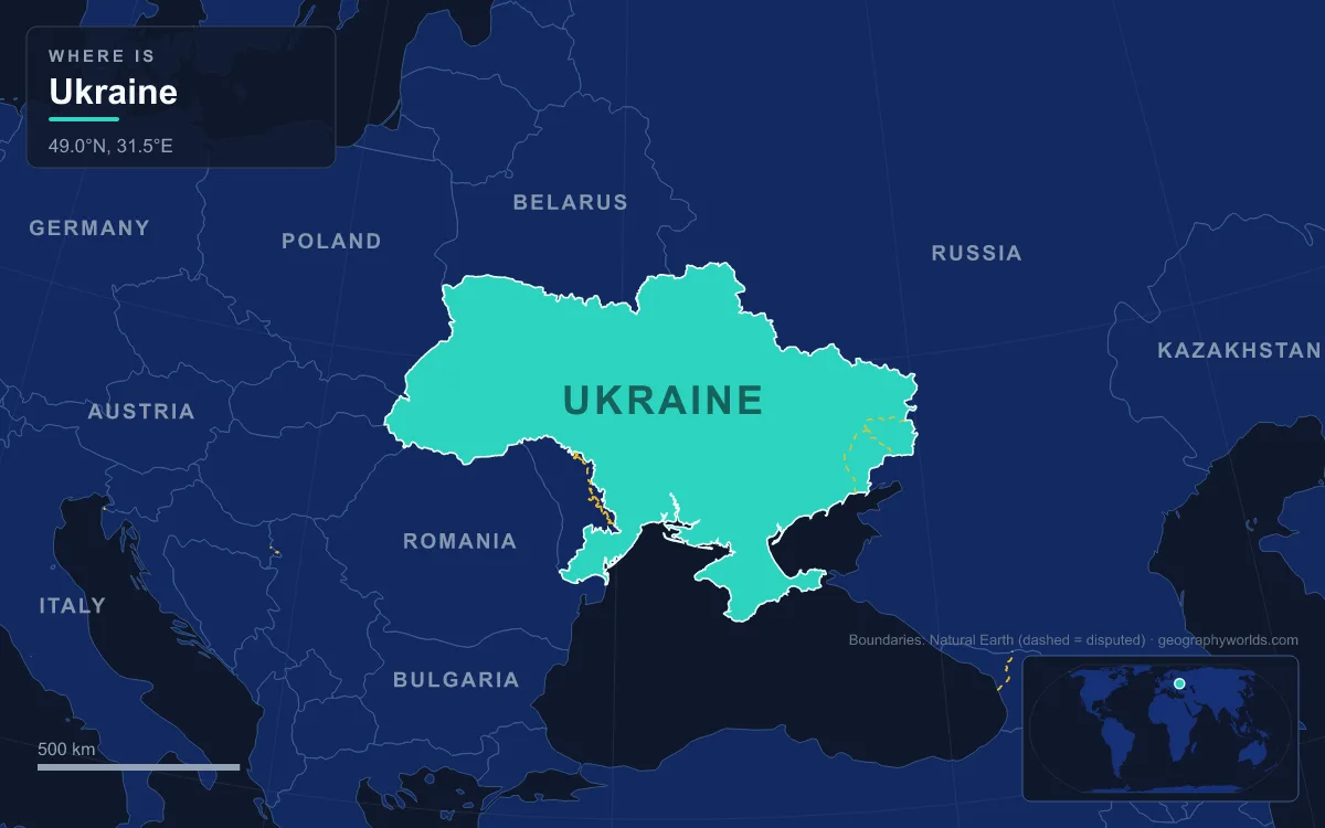
The answer is simple; the reasons people ask are more interesting. They involve a boundary that has moved several times since the ancient Greeks, a long frontier with a transcontinental neighbour, and a war that has redrawn the lines of control on the map.
Where the Ural and Caucasus Conventions Draw the Line
Europe and Asia sit on one landmass, Eurasia, and there is no ocean between them. Their boundary is a historical and cultural convention rather than a physical gap, and the version printed in most atlases today, including those of the National Geographic Society and The World Factbook, runs from the Aegean Sea through the Turkish Straits and across the Black Sea, along the watershed of the Greater Caucasus to the Caspian Sea, and then north along the Ural River and the Ural Mountains to the Kara Sea in the Arctic.
The Urals are the northern half of that line. They run north to south mostly through Russia, from the Arctic coast to the Ural River and northwestern Kazakhstan, reaching 1,894 m at Mount Narodnaya, and they separate European Russia from Siberia. Ukraine’s eastern frontier lies hundreds of kilometres west of the range, on the plains of the Donbas and the Central Russian Upland, so the Urals never come close to deciding the question. Russia, which straddles the line, is the country where the debate genuinely applies, as our guide to whether Russia is in Europe or Asia explains, and the mountains themselves are covered in our Ural Mountains guide.
The southern half of the line is where conventions differ most. The international geographic community has never agreed on one boundary through the Caucasus region between the Black and Caspian seas. The common atlas version follows the crest of the Greater Caucasus, which leaves the northern fringes of Georgia and Azerbaijan in Europe. Another, recommended in 1958 by the Soviet Geographical Society for textbooks, runs farther north along the Kuma–Manych Depression, a long, narrow lowland in southwestern Russia that stretches about 500 km from the lower Don valley near the Sea of Azov to the Caspian lowlands. That depression was once a marine strait joining the Black and Caspian basins, and the German naturalist Peter Simon Pallas identified it around 1773 as a natural divide. A third scheme uses the Aras River and the Turkish border, placing all of Armenia, Azerbaijan and Georgia in Europe.
All three variations matter for the Caucasus states, but none of them touches Ukraine. The Caucasus crest lies across the Kerch Strait and well to the southeast of Crimea, and the western end of the Kuma–Manych line is in the lower Don valley in Russia. Ukraine sits north and west of every one of these lines, on what is plainly the European side.
The Don, the Kerch Strait and the Classical Boundary
The one convention that came closest to Ukraine is also the oldest still discussed. The threefold division of the Old World into Africa, Asia and Europe goes back to Greek geographers of the 6th century BC such as Anaximander and Hecataeus, who drew the boundary along the Phasis River, the modern Rioni in Georgia. Later writers, including Strabo and Ptolemy, moved it north to the Tanais, the modern Don.
Ptolemy’s version held through the Middle Ages and into the 18th century. It followed the Turkish Straits, the Black Sea, the Kerch Strait, the Sea of Azov and the Don. The Kerch Strait, 3.1 to 15 km wide, separates the Kerch Peninsula of Crimea in the west from the Taman Peninsula of Russia’s Krasnodar Krai in the east. Even under this classical scheme, then, Crimea fell on the European side of the strait, and the lands north of the Sea of Azov lay west of the Don and therefore in Europe as well.

The shift east came in 1725, when Philip Johan von Strahlenberg abandoned the Don and drew the line along the Volga and the Ural Mountains. Mapmakers argued over the stretch between the lower Don and the Volga well into the 19th century; by the mid-1800s there were three main conventions in circulation, and the question was still treated as a controversy in the geographical literature of the 1860s. Each successive revision moved the boundary farther from Ukraine, not closer to it, which is why the country has been firmly European on maps for some three centuries.
Ukraine’s 603,628 km² From the Carpathians to the Sea of Azov
Most of Ukraine lies on the East European Plain, at an average height of about 175 m. Its landscape is mainly fertile steppe and plateau, with a central belt of the very fertile black earth soils known as chernozem. The Volhynia-Podillia Upland rises in the west and the Dnieper Upland on the right bank of the Dnieper; in the north lies the low, forested Polesian Lowland; and in the south the Black Sea Lowland runs down to the coast.
The rivers drain south to the Black Sea and the Sea of Azov. The Dnieper, about 2,200 km long, rises in Russia’s Valdai Hills, crosses Belarus and then splits Ukraine into its historic right and left banks, flowing past the capital, Kyiv, before reaching the Black Sea. The Dniester, the Southern Bug and the Siverskyi Donets follow similar southward courses, and in the southwest the Danube delta forms part of the border with Romania.
Mountains are confined to the edges. In the west, the Ukrainian Carpathians form part of the Eastern Carpathians, which continue into Poland and Romania. Their highest summit, Hoverla, at 2,061 m (6,762 ft), is the highest point in Ukraine and stands in the Chornohora massif; the main spring of the Prut River rises on its eastern slope. In the far south, the Crimean Mountains run along the peninsula’s coast.

Those same Carpathians hold one of Ukraine’s more unusual claims. In 1887, geographers of the Austro-Hungarian monarchy calculated a point near the village of Dilove, close to the town of Rakhiv where the White and Black Tisza join, and marked it with a 2 m geodesic obelisk carrying a Latin inscription; it is promoted as the geographic centre of Europe. The claim is contested: Kremnické Bane in Slovakia, Girija near Vilnius in Lithuania and a point near Polotsk in Belarus all make rival claims, because the answer depends on which extreme points of Europe are used. Whatever its merits, a country that claims Europe’s midpoint is not one geographers place in Asia.
Belarus, Poland, Russia and Ukraine’s Seven Land Neighbours
Ukraine shares land borders with seven countries, all of them European: Belarus to the north; Poland, Slovakia and Hungary to the west; Romania and Moldova to the southwest; and Russia to the east and northeast. Its southern edge is sea, a coastline of about 2,782 km on the Black Sea and the Sea of Azov, with an Exclusive Economic Zone of about 147,318 km² in the Black Sea.
Russia accounts for the longest stretch, 1,974 km, part of which runs through the Sea of Azov. That single frontier with a transcontinental state is a big part of why the question gets asked at all, yet the border itself runs across the East European Plain and the spurs of the Central Russian Upland, entirely within Europe. Smaller details show how tightly Ukraine is stitched into Central Europe: the village of Velké Slemence is split between Slovakia and Ukraine, and the Transcarpathian Lowland is an extension of the Great Hungarian Plain. Our page on the countries that border Ukraine goes through each frontier in turn.
Why the Soviet Union, Crimea and the War Make People Ask
The first reason is history. From 1922 Ukraine was a constituent republic of the Soviet Union, a state that genuinely spanned Europe and Asia, and for decades it was discussed as part of that single bloc. It became independent in 1991, adopted its constitution in 1996, and since then has steadily tied itself to European institutions. The political part of an Association Agreement with the EU was signed on 21 March 2014 and the economic part on 27 June 2014, and the European Council granted Ukraine candidate status on 23 June 2022.
The second reason is the war, which has changed who controls parts of the map. In February and March 2014, Russia seized the Crimean Peninsula and incorporated it on 18 March 2014 following a referendum held under Russian occupation. On 27 March 2014, UN General Assembly Resolution 68/262, backed by 100 member states, affirmed Ukraine’s territorial integrity within its internationally recognised borders; Russia treats Crimea as its own territory, while Ukraine and the resolution’s supporters regard it as Ukrainian. After its full-scale invasion in 2022, Russia declared on 30 September 2022 that it was annexing four Ukrainian oblasts, Donetsk, Kherson, Luhansk and Zaporizhzhia, none of which it fully controlled; that declaration is also not internationally recognised. Ukraine claims all of these areas as its territory, while Russia holds and administers large parts of them.
Neither change affects the continental answer. Crimea, the Sea of Azov coast and the Donbas all lie west of the Don and the Kerch Strait and far west of the Urals, so they are in Europe whichever state controls them. The UN estimated Ukraine’s population at about 36.7 million for 2026, down from almost 42 million in 2020, largely because of the war and the refugee outflow it caused. For the same question asked about its northern neighbour, see whether Belarus is in Europe or Asia.