
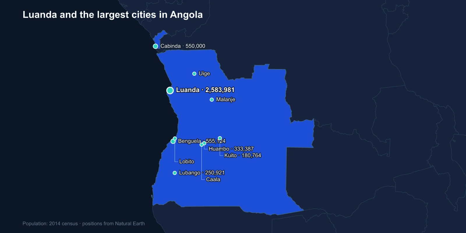
The largest cities in Angola are Luanda (2,583,981 in the municipality), Benguela (555,124), Cabinda (550,000), Huambo (333,387), Lubango (250,921), Kuito (180,764), Malanje (156,829), Lobito (145,652), Caala (130,000) and Uige (116,751). These come from the 2014 census, Angola's first in forty-four years.
The Luanda figure needs immediate qualification. It counts the municipality; the province of Luanda recorded 6.5 million in the same census, and the continuous built-up area is generally put between six and eight million today. By any metropolitan measure, Luanda holds close to a third of all Angolans.
A Census After Forty-Four Years
Angola's previous census was taken in 1970, under Portuguese rule. Independence came in 1975 and was followed immediately by a civil war between the MPLA government and UNITA that ran, with interruptions, until 2002 — twenty-seven years, one of the longest in Africa.
No count was possible during that period. When the 2014 census finally reported, the national total of 25.8 million was substantially higher than most working estimates, and the urban distribution it revealed had been transformed by the war in ways nobody had measured.
That is the central fact about this list: it is a photograph of a country reshaped by a conflict that ended twelve years before the shutter opened.
The War Filled the Cities
Angola's civil war was fought largely in the countryside and the highlands, and it was fought with landmines on a scale that left the rural interior lethal long after the shooting stopped. Millions of people moved to whichever city was controlled by a force that could feed them, and most of those cities were on the coast.
Luanda absorbed the largest share. A city built by the Portuguese for a few hundred thousand people took in millions, who settled in the musseques — informal districts of sandy ground on the plateau behind the colonial core, with no drainage, no piped water and no legal tenure.
When the war ended, they largely stayed. The land they had left was mined, the services were in the city, and a generation had grown up urban. Angola went from roughly 15 per cent urban at independence to a majority-urban country within thirty years, and it did so without the industrialisation that usually drives that change.
Oil Paid for a Skyline, Not for Housing
Angola is one of sub-Saharan Africa's largest oil producers, and the boom of the 2000s and early 2010s ran the money through Luanda. The waterfront was rebuilt, the Marginal promenade relaid, and towers went up along the bay.
For several consecutive years, surveys of the cost of living for expatriate workers named Luanda the most expensive city in the world — a ranking driven by the price of secure housing and imported goods for oil-company staff, in a city where the majority of residents lived in the musseques on very little.
The government's answer to the housing shortage was Kilamba, a satellite city of hundreds of apartment blocks built south of Luanda by a Chinese state construction firm and financed against oil. When it opened in 2012 it was almost entirely empty, because the flats were priced far beyond what most Luandans could pay, and it circulated internationally as a ghost city. Prices were later cut and it has since filled up, but the episode captured the mismatch precisely.
Benguela, Lobito and the Railway to the Copper
Benguela and Lobito sit next to each other on the central coast and function as a pair: the older colonial town founded in 1617, and the deep-water port built beside it in the twentieth century.
Lobito is the Atlantic terminus of the Benguela Railway, which runs 1,300 kilometres inland through Huambo to the Congolese border and on to the copper and cobalt belt of Katanga. Completed in 1929, it was the shortest route from central African mines to the sea, and it was destroyed and mined during the civil war.
Its reconstruction, finished in 2014, and the subsequent Lobito Corridor investment backed by the United States and the European Union, have made this stretch of Angolan coast strategically interesting again — the alternative to shipping Congolese cobalt east through Tanzania or south through South Africa.
The Highlands, and the City That Was Destroyed
Huambo, on the central plateau at around 1,700 metres, was built by the Portuguese as Nova Lisboa and was intended at one point to become the colonial capital. It sits in the most fertile and temperate part of the country, the Ovimbundu heartland.
It was also UNITA's base, and it was fought over repeatedly. The siege of 1993, sometimes called the fifty-five day war, left much of the city in ruins and killed thousands. Kuito, further east, suffered even more comprehensively — it was besieged for nine months in 1993 and 1994 and is often described as the most damaged city of the entire conflict, with essentially no building left intact in the centre.
Both have been rebuilt. Their presence in the top ten reflects the natural weight of the highlands, which held the majority of Angola's population before the war pushed it towards the coast.
Cabinda Is Not Attached to the Country
Third on the list is a city in a province separated from the rest of Angola by a strip of Congolese territory about sixty kilometres wide, where the Congo River reaches the sea.
Cabinda is an exclave, and it produces a large share of Angola's oil from offshore fields. That combination — physically detached, economically essential — has sustained a separatist movement, the FLEC, since the 1960s, and the province has a security presence out of proportion to its size.
Travelling from Luanda to Cabinda by road means crossing the DR Congo twice, or taking the ferry across the Congo estuary. Most people fly.
Lubango and the South
Lubango sits on the Huila plateau in the south-west, founded by settlers from Madeira in 1885 and known as Sa da Bandeira until independence. It has a statue of Christ the King above the town, modelled on the one at Lisbon, and the Tundavala Gap nearby — a fissure where the plateau drops more than a kilometre straight down to the plain.
The south is also where Angola's pastoralist peoples live, including the Himba and Mumuila, and Lubango is the commercial centre for a region that is drier, emptier and more oriented towards Namibia than towards Luanda.
South of Lubango the land runs into the Namib, and the coastal town of Namibe — formerly Mocamedes — sits on one of the driest shorelines in the world, where the cold Benguela Current suppresses rainfall almost entirely and fog is the main source of moisture.
Malanje, Uige and the Interior
Malanje in the north-centre and Uige in the north-west are the largest interior cities outside the highlands. Malanje is the access point for the Kalandula Falls, among the largest waterfalls in Africa by volume, and for the Pungo Andongo rock formations.
Uige was the centre of Angola's coffee industry, which before independence made the colony one of the world's largest robusta producers. The plantations were abandoned during the war and the industry has recovered only partially, with output a fraction of its 1970s peak.
Caala, ninth on the list, sits just outside Huambo on the Benguela Railway and is effectively part of the same highland urban cluster. Its appearance in the top ten alongside Huambo is a reminder that the plateau, not the coast, is where most Angolans lived before the war — and that the highlands are slowly regaining the weight they lost to Luanda.
A Capital That Predates the Colony
Luanda was founded in 1576 by Paulo Dias de Novais and is one of the oldest European-established cities in sub-Saharan Africa. For most of its first three centuries its business was the Atlantic slave trade, and it was the single largest point of embarkation anywhere: the great majority of enslaved people taken to Brazil left from Luanda and Benguela.
That history is why Angola and Brazil share so much — language, music, religious practice — and why Brazilian influence on Angolan culture remains obvious. The city's colonial core, the fortress of Sao Miguel above the bay and the churches below it, dates from that period.
Where the Diamonds Are
One region conspicuously absent from the top ten is the north-east. The Lunda provinces hold Angola's diamond fields, and they financed UNITA through the later stages of the war — the original blood diamonds that prompted the Kimberley Process certification scheme.
Saurimo and Dundo are the regional centres, and both are smaller than their economic importance suggests. Diamond mining employs relatively few people directly, the concessions are tightly controlled, and the area never developed the urban weight that the copper belt gave to southern DR Congo.
What the Ranking Records
Angola's city list is the map of a displacement. A colonial capital that took in a third of the nation, a pair of ports tied to a railway into the Congo, highland cities that were besieged and rebuilt, and an oil exclave that is not joined to the country it funds.
How the plateau, the coast and the Namib fit together is set out in our Angola country guide, and Angola’s position in southern Africa explains the corridors its ports serve. The city that took in a third of the country is examined in the Luanda profile.
