
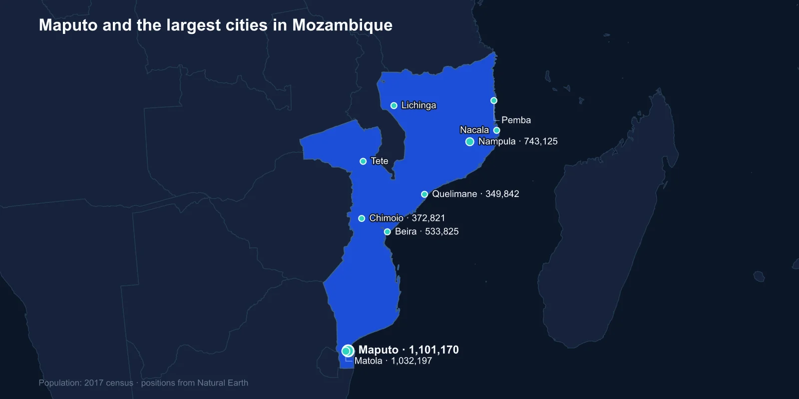
The largest cities in Mozambique are Maputo (1,101,170), Matola (1,032,197), Nampula (743,125), Beira (533,825), Chimoio (372,821), Quelimane (349,842), Tete (305,722), Nacala (225,034), Lichinga (213,361) and Pemba (201,846). These are 2017 census figures, the most recent national count.
The first two entries are neighbours. Matola sits directly west of Maputo and the two form a single conurbation of well over two million people, which is roughly a fifth of all urban Mozambicans in one corner of a very long country.
A Country Shaped Like a Coastline
Mozambique runs about 2,500 kilometres from the South African border to the Tanzanian one, and its cities are strung along that coast like beads. There is no interior urban system to speak of; only Chimoio, Tete and Lichinga sit meaningfully inland, and each of those is on a route to a landlocked neighbour.
That shape is a colonial inheritance. Portuguese Mozambique was administered as a set of coastal trading stations and, for a long period, leased to chartered companies that ran whole provinces as commercial concessions. The territory was never integrated into a single economy, and the transport links still run east to west — from each port inland — rather than north to south.
There is no continuous paved highway along the entire length of the country that avoids seasonal disruption, and flying between Maputo and the northern cities is often faster than any surface route.
Maputo Is in the Wrong Place for Its Own Country
Maputo sits in the extreme south, on a bay close to the borders with South Africa and Eswatini. It is roughly 500 kilometres from Johannesburg and about 2,000 from Pemba in the far north. For most of the country, the capital is a very long way away.
That position made complete sense under Portuguese rule. The city, then Lourenco Marques, existed largely to serve the Transvaal: it was the closest port to the Witwatersrand goldfields, and the railway between them carried South African mineral traffic and Mozambican migrant labour in the opposite direction. The capital moved there from Ilha de Mocambique in 1898 precisely because the money was in that corridor.
The city retains a striking colonial core — a Portuguese-built downtown, an iron house attributed to the Eiffel workshop, and a railway station with a domed roof that appears on lists of the world's most handsome. Behind it, as in Luanda, lie the informal caniço districts where most residents live.
Nampula and the Northern Weight
Nampula, third on the list, is the largest city of the north and the commercial hub for a region that holds a substantial share of the national population. It is a railway town, built at the junction of the line running inland from Nacala.
The north is culturally distinct from the south — predominantly Makhuwa and Muslim, with a long Swahili and Indian Ocean trading history — and the political geography reflects it. Renamo, the movement that fought the government through the civil war and has contested elections since, has drawn its support from the centre and north rather than the Frelimo-dominated south.
Nearby is Ilha de Mocambique, the small coral island that was the capital of Portuguese East Africa for four centuries. Its stone town is a UNESCO World Heritage Site, and it is now a place of a few thousand people — a former capital reduced to a village by the shift of trade southwards.
Beira, the Port for Two Landlocked Countries
Beira is the second port and the outlet for the Beira Corridor, the rail, road and pipeline route that carries the trade of Zimbabwe, Zambia and Malawi to the sea. During the Rhodesian sanctions period and the Mozambican civil war, control of that corridor was a strategic objective for several armies at once.
The city is also the most exposed. Beira sits on low, flat ground at the mouth of the Pungwe, barely above sea level and partly protected by an ageing seawall, and in March 2019 Cyclone Idai made landfall almost directly on it.
The storm destroyed a large proportion of the city's buildings, flooded an inland area visible from space as a temporary lake, and killed more than a thousand people across the region. Cyclone Kenneth struck the far north six weeks later — the first time two cyclones of that strength had hit Mozambique in a single season.
Tete, the Zambezi and the Coal
Tete sits on the Zambezi in the north-west, at the only bridging point on the river for hundreds of kilometres, which has made it a crossing town since the Portuguese established a garrison there in the sixteenth century. Traffic between Malawi, Zambia, Zimbabwe and the coast funnels across it.
The province holds the Moatize coal basin, one of the largest undeveloped coking coal deposits in the world, and the boom of the 2010s brought mining companies, a resettlement programme and a rebuilt railway to Nacala. Prices fell, some of the investors left, and Tete has been left with the infrastructure of a boom that did not entirely arrive.
Upstream is Cahora Bassa, the dam completed in 1974 whose hydroelectric output is exported largely to South Africa — another example of Mozambican infrastructure oriented towards a neighbour rather than towards the country it sits in.
Nacala Has the Best Harbour in the Region
Nacala is a deep-water natural harbour, one of the finest on the eastern African coast, capable of taking vessels that cannot enter Beira or Maputo. It is the terminus of the Nacala Corridor railway that runs inland through Malawi to the Moatize coalfields.
Its potential has been discussed for decades and realised only partially. The port handles a fraction of the traffic its geography would justify, and the corridor's fortunes have tracked the coal market closely.
The bay also has an aviation footnote. Nacala's runway was built long enough to serve as an emergency landing site for the American space shuttle, one of a small number of such designated strips outside the United States, chosen for the length of its runway and its position under an orbital track.
Pemba, Lichinga and the Gas in the North
Pemba, on another very large natural bay in the far north, and Lichinga, inland near Lake Malawi, are the smallest entries in the top ten and sit in the most remote provinces.
Cabo Delgado province, of which Pemba is the capital, holds one of the largest natural gas discoveries of this century in the Rovuma basin offshore. The projects attached to it are among the biggest private investments ever made in Africa.
Since 2017 the province has also been the site of an armed insurgency that has displaced close to a million people, attacked the town of Palma in 2021 and forced the suspension of the largest gas project for several years. Pemba has absorbed much of the displacement, and its population is now well above the census figure.
Quelimane, Chimoio and the Middle
Quelimane sits on the Bons Sinais river in Zambezia province, reached from the sea through a shallow channel that has always limited its port. It was a major point of embarkation in the Indian Ocean slave trade, and later the centre of a coconut and copra industry — the plantations at Quelimane were once among the largest in the world.
Chimoio, inland on the Beira Corridor towards Zimbabwe, is a transport and agricultural town that grew substantially during the civil war as people moved off the land into defended centres. It is now the fifth-largest city in the country and the main market for the fertile Manica highlands.
Sixteen Years of Civil War
Mozambican independence in 1975 was followed within two years by a civil war that ran until 1992 and killed around a million people. It was fought largely in the countryside, and it was fought with landmines and with deliberate attacks on rural infrastructure — schools, clinics, railways.
The demographic effect was the same as in Angola: people moved into the cities because the cities were defensible. Chimoio, Tete and the district capitals swelled with displaced families, and much of that population stayed after the peace agreement. The urban Mozambique described by this list was substantially assembled by that war.
What the Census Does Not Show
The 2017 count predates both Cyclone Idai and the worst of the Cabo Delgado conflict, the two events that have moved Mozambican populations most in the years since. Beira's figure describes a city before a third of it was destroyed; Pemba's describes a town before it became a refuge.
The underlying trend is nonetheless clear. Mozambique is urbanising fast from a low base, and the growth is concentrated in the Maputo-Matola conurbation and in Nampula rather than spread evenly along the coast.
One further wrinkle affects comparisons. Mozambican census figures report cidades, municipalities with formal city status, and the boundaries were drawn at independence around colonial urban cores. Settlement that has grown beyond them is counted with the surrounding district, which is a large part of why Maputo and Matola appear as two cities rather than one.
Why so many neighbours depend on Mozambican ports becomes clear from its position in southern Africa. The Maputo profile looks at the capital in its awkward southern corner, and the coast and the Zambezi are covered in our Mozambique country guide.
