
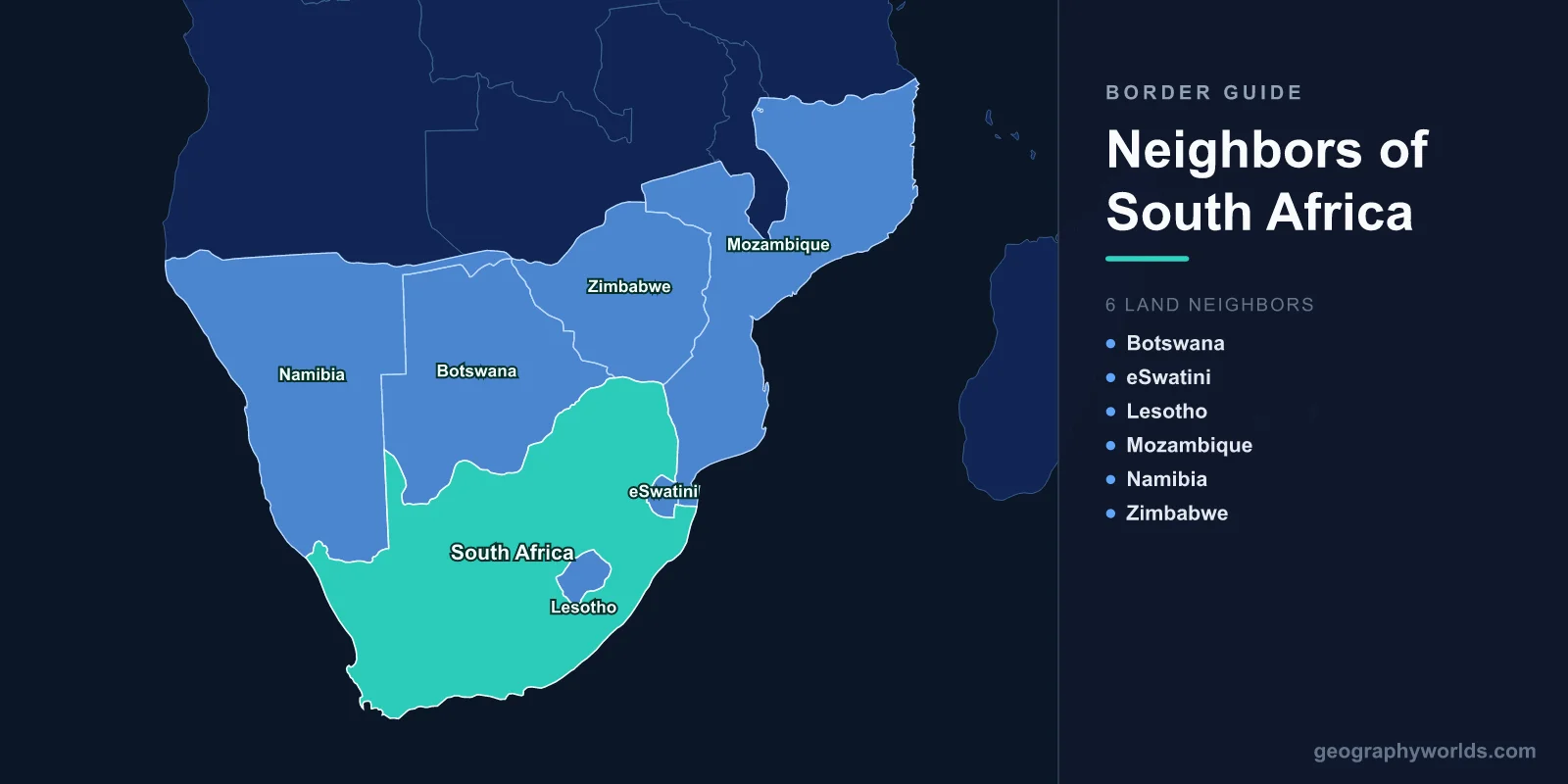
South Africa shares land borders with six neighboring countries: Namibia, Botswana, Zimbabwe, Mozambique, Eswatini, and Lesotho. Together these borders stretch roughly 5,244 km around the southern tip of the African continent. Five of these neighbors lie along South Africa's northern and eastern frontiers, while the sixth, Lesotho, is unusual: it is completely surrounded by South African territory on every side. The rest of the country's perimeter is ocean, since South Africa occupies the very bottom of Africa where the Atlantic and Indian Oceans meet.
The Six Countries That Border South Africa
South Africa occupies the southernmost portion of Africa, with the Atlantic Ocean to the west and the Indian Ocean to the east and south. Its land frontier curves across the north and northeast, touching the following nations:
- Namibia — to the northwest, separated in part by the Orange River and the arid Kalahari fringe.
- Botswana — to the north, across the Kalahari and the Molopo and Limpopo river systems.
- Zimbabwe — to the north, with the Limpopo River forming much of the boundary.
- Mozambique — to the northeast, near the Kruger National Park and the Indian Ocean coast.
- Eswatini (formerly Swaziland) — to the east, a small landlocked kingdom nearly enclosed by South Africa.
- Lesotho — entirely enclaved within South Africa, perched high in the Drakensberg mountains.
For a deeper look at the country itself, see our south africa country guide.
How Long Is Each Border?
South Africa's land boundaries vary enormously in length, reflecting how the country wraps around some neighbors and merely brushes others. The approximate lengths of each frontier are:
- Botswana: roughly 1,840 km — the longest of all, running across the dry interior plateau.
- Namibia: about 1,005 km, much of it traced by the Orange River.
- Mozambique: around 495 km along the eastern lowveld.
- Zimbabwe: about 230 km, defined largely by the Limpopo River.
- Eswatini: roughly 440 km wrapping around three sides of the kingdom.
- Lesotho: about 1,106 km, a complete ring around the enclaved nation.
Adding these together produces the total land frontier of approximately 5,244 km. Notably, the border with Lesotho — a country smaller than many South African provinces — is longer than the border with neighboring Mozambique, simply because South Africa must surround Lesotho entirely.
Rivers and Mountains That Form the Borders
South Africa's boundaries are shaped strongly by natural features. The Orange River, the country's longest river, defines a long stretch of the frontier with Namibia in the dry northwest. To the north, the Limpopo River marks much of the border with Botswana and Zimbabwe, sweeping in a wide arc before turning toward Mozambique and the sea.
In the east, the high wall of the Drakensberg escarpment rises sharply, helping define the border with Lesotho and the western edge of Eswatini. These mountains include some of the highest terrain in Southern Africa, and Lesotho's elevation is so consistently high that it is sometimes called the "Kingdom in the Sky." The varied terrain — from desert sands to subtropical lowveld to alpine peaks — gives South Africa one of the most geographically diverse border regions on the continent.
Lesotho and Eswatini: The Enclaved and Nearly Enclaved Kingdoms
Lesotho holds a rare distinction: it is one of only three fully enclaved countries in the world, surrounded entirely by a single other nation. (The other two are San Marino and Vatican City, both inside Italy.) Every road, rail, and trade route into Lesotho passes through South African territory, which makes the two countries deeply interdependent. Lesotho supplies large volumes of water to South Africa's industrial heartland through the Lesotho Highlands Water Project, one of the largest water-transfer schemes in Africa.
Eswatini is almost enclaved as well. It is bordered by South Africa on its north, west, and south, with only a short eastern boundary shared with Mozambique. As one of Africa's few remaining absolute monarchies, the small kingdom maintains close economic ties with its larger neighbor, and many Eswatini workers and goods move across the border daily. Both kingdoms use currencies pegged to the South African rand, which circulates freely alongside the local Lesotho loti and Eswatini lilangeni.
Border Crossings, Trade, and Movement
The long South African frontier hosts dozens of official border posts. Among the busiest is Beitbridge, the crossing into Zimbabwe over the Limpopo River, which handles enormous volumes of regional trade and migration. The Lebombo post connects to Mozambique near Maputo, while Maseru Bridge is the main gateway to Lesotho's capital. Other significant posts include Oshoek (Ngwenya) into Eswatini, Skilpadshek into Botswana, and Vioolsdrif across the Orange River into Namibia.
All six neighbors, together with South Africa, belong to the Southern African Development Community (SADC), a bloc that promotes regional cooperation. Five of them — South Africa, Namibia, Botswana, Eswatini, and Lesotho — also form the Southern African Customs Union (SACU), the oldest customs union in the world, which dates back to 1910. These arrangements ease the flow of goods and people across what are some of the most economically active borders in Africa, and South Africa's large economy acts as the regional hub through which much of this trade passes.
Why South Africa Has No Sea Borders to the South
Because South Africa sits at the continent's southern tip, much of its perimeter is coastline rather than land border. Its roughly 2,800 km of coast meets the Atlantic Ocean on the west and the Indian Ocean on the south and east, with the two oceans often said to converge near Cape Agulhas, the southernmost point of Africa. This combination of long ocean frontage and a single arc of land neighbors gives the country its distinctive shape and its strategic position on global shipping routes, including the busy Cape sea route that links Europe and Asia around the continent.
Key Facts
- Number of bordering countries: 6 (Namibia, Botswana, Zimbabwe, Mozambique, Eswatini, Lesotho)
- Total land border length: approximately 5,244 km
- Coastline length: about 2,800 km, fronting two oceans
- Longest land border: with Botswana (~1,840 km)
- Fully enclaved neighbor: Lesotho, surrounded entirely by South Africa
- Major boundary rivers: the Orange (with Namibia) and the Limpopo (with Botswana and Zimbabwe)
- Shared regional bloc: all six neighbors belong to SADC
Frequently Asked Questions
How many countries border South Africa?
South Africa borders six countries: Namibia, Botswana, Zimbabwe, Mozambique, Eswatini, and Lesotho. Its total land border length is about 5,244 km.
Which country is completely surrounded by South Africa?
Lesotho is entirely enclaved within South Africa, with no border touching any other nation. It is one of only three fully enclaved countries in the world.
Does South Africa border Zimbabwe?
Yes. South Africa shares a northern border with Zimbabwe, largely along the Limpopo River, with the main crossing at Beitbridge.
Is Eswatini surrounded by South Africa?
Almost. Eswatini is bordered by South Africa on three sides — north, west, and south — and shares a short eastern boundary with Mozambique.