

Port Vila is the capital and largest city of Vanuatu, a Y-shaped chain of about 83 islands in the South Pacific. It sits on the southwest coast of Efate, in Shefa Province, around a sheltered harbour opening onto Mélé Bay. The 2020 census counted 49,034 people in the city, 16.3% of Vanuatu’s 300,019. Locals simply call it Vila, and it is where almost everything national happens at once: the Parliament, the main international airport, the busiest port and nearly nine in ten of the country’s imports.
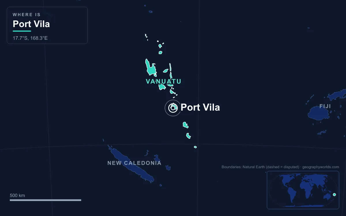
Port Vila is best understood by comparison: small by world standards, large by Vanuatu’s, modest beside its Melanesian neighbours, and unusually exposed to cyclones and earthquakes.
49,034 Residents: One Ni-Vanuatu in Six
A city of about 49,000 would be a market town in most of Europe. In Vanuatu it is the metropolis. Roughly one person in six in the whole country lives in Port Vila, and Efate, the island around it, is the most populous in the archipelago. Most of Efate’s inhabitants live in the capital; outside Vila, the island is villages, plantations and peri-urban communities such as Pango, 7 km away on the south coast.
The rest of Vanuatu looks very different. The population is spread over 65 inhabited islands with about 1,300 km between the most northerly and most southerly islands, and most people still live rurally. Vila’s growth has come from that countryside: people from other islands arrive for work, school or hospital care and stay for months or for good. The 2020 census found that 79.1% of the capital’s residents could read an indigenous language, a sign of how many carry a home-island identity into the city.

Port Vila Versus Luganville and Espiritu Santo
Vanuatu has one real rival city: Luganville, on Espiritu Santo in the north, with 17,719 people in 2020. Port Vila is therefore about 2.8 times its size. The contrast is sharper still when you compare the islands. Espiritu Santo is the country’s largest island at 3,955.5 km², more than four times the 899.5 km² of Efate, which ranks only third. Yet rural Santo, outside Luganville, had 37,328 people in 2020, fewer than the capital alone, and even with Luganville added the whole island falls short of Efate.
The two towns grew from different histories. Luganville was pulled together during the Second World War, when the United States built its largest South Pacific base on Santo; its main street, Boulevard Higinson, is unusually wide because a base commander wanted four tanks able to drive along it side by side. Port Vila also hosted Americans, but it was already the seat of colonial government.
Politics split them in 1980. Luganville was largely French-speaking and resisted the independence movement led from Vila. In late May 1980 Jimmy Stevens’ Nagriamel movement declared Santo independent as the Republic of Vemerana, and the rebels blockaded the airport. Independence went ahead from Port Vila on 30 July 1980 regardless, and after Anglo-French troops were withdrawn, Prime Minister Walter Lini called in soldiers from Papua New Guinea. In the brief episode known as the Coconut War, Stevens surrendered at the end of August. Luganville remains the northern hub, served by Santo-Pekoa International Airport, but the capital has never been in question since.
Smaller Than Honiara, Suva and Nouméa
Among the capitals of Melanesia, Port Vila is the small one. Honiara, capital of Solomon Islands, had 129,569 people in 2019, more than two and a half times Vila’s count. Suva in Fiji had 93,874 in the city proper at the 2017 census and about 268,000 across the metropolitan corridor to Nausori. Nouméa, capital of the French collectivity of New Caledonia to the south, counted 85,976 in its commune in April 2025, down from 94,285 in 2019 after the 2024 riots pushed thousands of residents away.
Vila shares something with each. Like Honiara, it was shaped by the Pacific war of 1942, when airfields on Guadalcanal and Efate became Allied assets within months of each other. Like Nouméa, it carries a strong French imprint, with French-language schools and French still widely spoken. Like Suva, it hosts regional institutions: the University of the South Pacific, co-owned by twelve Pacific countries, runs a campus in Port Vila that houses the university’s only law school. What Vila lacks is scale, and that makes each national function sit very close to the next. The Vanuatu Cultural Centre and National Museum stand in Saralana Park facing the National Parliament, beside the National Library and the Malvatumauri, the National Council of Chiefs.

Mélé Bay Weather: 320.9 mm in March, 87.3 mm in September
Temperature barely moves in Port Vila; rain does. Average highs run from 31.2 °C in February, the hottest month, to 26.4 °C in July, a spread of under five degrees. The annual mean is 24.3 °C, and the recorded extremes are 35.6 °C and 8.5 °C. Rainfall, by contrast, swings almost fourfold. March, the wettest month, averages 320.9 mm; September, the driest, averages 87.3 mm. Across the year about 2,338.9 mm falls on 153 wet days.
Climatologists class this as a maritime trade-wind climate rather than a truly equatorial one, because the southeast trades blow almost constantly and cyclones are a regular visitor. The practical result is two seasons: a hot, humid wet season from roughly November to April, when cyclones form, and a cooler, drier stretch from July to September that lines up with the southern winter. Visitors weighing those months will find the trade-offs set out in our guide to the best time to visit Vanuatu.
Franceville in 1889, the Condominium in 1906
The same shoreline has been lived on for about 3,000 years. In 2003 and 2004 archaeologists at Teouma, on Efate’s south coast, uncovered a Lapita burial ground of about 25 graves holding some three dozen people, with pottery dated to the 13th century BC. It is the oldest known cemetery in the Pacific Islands, and DNA from three of the women buried there links the first settlers to Taiwan and the northern Philippines. The name Vila itself comes from local speech: the area is Efil in the South Efate language and Ifira in neighbouring Mele-Fila. Ifira is also a small island in Vila Harbour where many of the traditional landowners live.
European history arrived late and in duplicate. James Cook charted Efate in 1774 and called it Sandwich Island without landing. The British had the stronger presence at first, but French plantations were spreading, and French citizen Ferdinand Chevillard bought and cleared land around the harbour for what was meant to be the largest French plantation on the island. On 9 August 1889 the settlers declared the independent commune of Franceville, with Chevillard as elected mayor and a vote open to all regardless of sex or race. The experiment was suppressed and effectively broken up by June 1890.
From 1887 an Anglo-French Joint Naval Commission policed the islands, and in 1906 the two powers formalised the Condominium of the New Hebrides. Almost everything came in pairs: two police forces, two health services, two education systems, two currencies and two prison systems, meeting only in a Joint Court. In 1942 the Americans arrived: Marines cleared a coral strip 2,000 ft long on a plantation, and Seabees stretched it to 6,000 ft. It was named Bauer Field after Lt-Col Harold W. Bauer, a Marine fighter pilot lost at sea on 14 November 1942. At the peak of the war, about 50,000 American personnel on Efate and Santo outnumbered the islands’ roughly 40,000 indigenous inhabitants.
Cyclone Pam in 2015 and the 7.3 Earthquake of December 2024
Few capitals this size have been hit as hard in one decade. Vila sits close to the New Hebrides Trench, where the Australian Plate dives beneath the New Hebrides Plate in one of the most active plate boundaries on Earth. Cyclone Uma severely damaged the city in 1987, and an earthquake on 3 January 2002 caused minor damage.
Then came Cyclone Pam. On 13 March 2015 the Category 5 storm, with sustained winds of about 250 km/h, tracked through Vanuatu with its eye wall passing just east of Port Vila. Nationally, 15 to 16 people died and thousands of homes, schools and buildings were damaged or destroyed.
Less than a decade later, at 12:47 local time on 17 December 2024, a magnitude 7.3 earthquake struck near the city. At least 14 people died and 265 were injured, a 25 cm tsunami followed, and the UN Office for the Coordination of Humanitarian Affairs estimated that 116,000 people were directly affected, about a third of the national population. Bauerfield’s runway, rebuilt in 2019 with World Bank funding, was closed to non-humanitarian flights for 72 hours; commercial flights resumed on 22 December. The shock came months after another blow to the capital’s links with the world: Air Vanuatu, whose first flight left Sydney for Port Vila on 5 September 1981, was placed into liquidation in May 2024, with limited domestic flights restarting that August.
Bislama, English and French in One Small Capital
For its size, Port Vila is unusually multilingual. Bislama is the everyday lingua franca, but the Condominium left two school systems behind, and the 2020 census found 90.0% of the city’s population literate in English and 47.0% in French. On top of that sit many of Vanuatu’s 138 indigenous languages, carried in by migrants from the outer islands.
Religion is less divided. More than 90% of Ni-Vanuatu are Christian, and the Presbyterian Church in Vanuatu is the largest denomination, with about a third of the population; its Port Vila church faces Independence Park. The Roman Catholic Cathédrale du Sacré-Cœur is the seat of the Diocese of Port Vila.
The economy is similarly concentrated. The harbour handles 35.7% of Vanuatu’s exports and 86.9% of its imports. Offshore banking has been part of the city since the early 1970s, when the territory’s tax-haven status drew a building boom; a new deep-sea wharf let cruise arrivals reach 40,000 a year by 1977, and more than 80,000 visitors came in 1997, many from Australia and New Zealand. Aid from Australia, New Zealand and increasingly China funds much of the rest, from doctors’ training to consultants at Port Vila Central Hospital.
Put all of that together and the defining contrast is clear: a town the size of a regional market centre carrying the full weight of a sovereign state, its parliament, port, airport and cultural archive within a few kilometres of one another. For the wider picture of the islands it governs, from Tanna’s volcano to Santo’s mountains, continue with our Vanuatu country guide, or compare Vila with its larger neighbour in our profile of Honiara, capital of Solomon Islands.
Quick Facts About Port Vila
- Country: Vanuatu
- Continent: Oceania
- Country population: approximately 343 thousand
- Capital city status: Port Vila is the capital of Vanuatu, the seat of national government, and the location of foreign embassies, parliament, and the head of state's official residence.
Frequently Asked Questions
What is the capital of Vanuatu?
The capital of Vanuatu is Port Vila. Port Vila is the seat of national government, hosts most foreign embassies and consulates, and is typically where the head of state and parliament are located.
What continent is Port Vila in?
Port Vila, the capital of Vanuatu, is located in Oceania. As Vanuatu's capital, Port Vila serves as the country's primary connection to the broader Oceanian political, economic, and cultural sphere.
Why is Port Vila the capital of Vanuatu?
Port Vila was chosen as the capital of Vanuatu for reasons that typically combine geography, history, and politics. Capital city selections often reflect a desire for centrality (being accessible from across the country), historical importance (being a longstanding seat of government or culture), or neutrality (being acceptable to multiple regions or ethnic groups within the country). The specific reasons for Port Vila's designation are detailed in the city's history above.
What is Port Vila known for?
As the capital of Vanuatu, Port Vila is best known for housing the country's central government institutions — parliament, presidential or royal residences, supreme court, and key ministries. It is also typically a major cultural and economic center within Vanuatu, hosting national museums, embassies, and signature monuments. The introduction and history sections above provide detailed coverage of the city's specific notable institutions and landmarks.
Related Pages
- Vanuatu Country Guide — full geography, climate, economy, and culture overview
- Flag of Vanuatu — meaning, history, and design of Vanuatu's national flag