
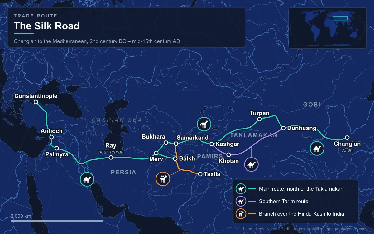
The Silk Road was a network of overland trade routes that linked China with Central Asia, Iran and the Mediterranean from the second century BCE until the mid-15th century, covering more than 6,400 km (4,000 mi) on land. It opened after the Han envoy Zhang Qian’s missions to Central Asia, and by the first century CE Chinese silk shipped from the Han capital at Chang’an (modern Xi’an) was in demand in Rome, Egypt and Greece. Silk brocade, lacquerware and porcelain went west; horses, honey, wine, gold, glass and Persian pistachios came east. Few people travelled its whole length: goods passed between middlemen at a chain of oasis towns, and with them moved Buddhism, Manichaeism, Islam, papermaking and disease, including plague that may have contributed to the Black Death. The clearest way to understand it is to follow it stop by stop.
Chang’an (Xi’an): Where Zhang Qian Set Out in 138 BCE
The eastern end of the northern route was Chang’an, capital of the Western Han and later the Tang between 202 BCE and 907 CE. In 138 BCE Emperor Wu of Han sent Zhang Qian west from here with a party of 99 people to seek an alliance with the Yuezhi against the Xiongnu, the nomadic confederation that controlled the steppe and the approaches to the Western Regions. The Xiongnu captured him and held him for thirteen years. When he finally returned, his reports on Dayuan (the Fergana Valley), Bactria and Parthia gave the Han court its first detailed picture of Central Asia, and the court began sending embassies: the historian Sima Qian wrote that five to more than ten parties went out each year, the largest numbering several hundred people.
Under the Tang, Chang’an grew into what Chinese records called a “million-man city”; most modern estimates put the population inside its walls at around 800,000 to 1,000,000 in about 750 CE. Sogdian merchants kept quarters there, and the monk Xuanzang brought back the Buddhist texts he had collected in India to this city. The Giant Wild Goose Pagoda, first built in 652 under his direction to store those scriptures, still stands in southern Xi’an.
The Hexi Corridor and the Jade Gate
West of the Yellow River, every caravan had to thread the Hexi (or Gansu) Corridor, a strip of oases about 1,100 km long and generally 40 to 100 km wide. The Qilian Mountains, with peaks above 4,500 m, wall it to the south; the Badain Jaran and Gobi deserts lie to the north. Meltwater from the Qilian fed a line of oasis towns that are still the corridor’s cities today: Wuwei, Zhangye, Jiuquan and Jiayuguan. Whoever held this strip controlled access between China and the west, which is why Emperor Wu extended the Great Wall along it.
The corridor also carried the Han dynasty’s demand for horses. Zhang Qian reported that Dayuan bred fast “heavenly horses”, and when trade talks failed Emperor Wu sent two expeditions, in 104 and 102 BCE, that ended in a Han victory and pushed Han influence deep into Central Asia. At the corridor’s western end stood the Jade Gate (Yumenguan), erected soon after 121 BCE about 80 km northwest of Dunhuang. It was named for the jade caravans from Khotan that entered through it. Its square enclosure of 10-metre mud walls still stands; Aurel Stein found bamboo slips naming the site in 1907.
Dunhuang and the Mogao Caves
Dunhuang was fortified and settled after Emperor Wu’s armies drove out the Xiongnu, and its commandery was probably set up shortly after 104 BCE; its name means “blazing beacon”, after the watchtower fires that warned of nomad raids. Until the sixth century it was the last Chinese outpost before the desert, and caravans had to pass either the Jade Gate or the Yang Pass, about 68 km apart. Buddhism travelled east past this point, and from 366 CE monks began cutting shrines into a cliff 25 km southeast of the town. Work on the Mogao Caves continued for about a thousand years, until the 14th century, leaving some 500 cave temples covered with murals and sculpture.

The site’s most important find was a sealed side chamber, the Library Cave, walled up in the 11th century and opened in 1900 by the Daoist monk Wang Yuanlu. Its manuscripts are now divided between Beijing, London, Paris and Berlin. Among them was a printed copy of the Diamond Sutra dated 11 May 868, sold to Stein in 1907 and generally regarded as the oldest surviving dated printed book. Sogdian letters of the fourth to sixth centuries have also been found around Dunhuang and Loulan; one, dated 313 CE and found in a ruined watchtower in Gansu, was addressed to merchants in Samarkand, warning that after the sack of Luoyang there was no business left there for Indian and Sogdian traders.
Turpan, Below Sea Level on the Northern Rim
Beyond Dunhuang the route split around the Taklamakan Desert, which covers about 337,000 km² of the Tarim Basin. The southern branch ran along the foot of the Kunlun Mountains through Khotan and Yarkand; the northern branches skirted the Tian Shan. One of those passed through Turpan, an oasis in a fault-bounded depression whose lowest point, Lake Ayding, lies 154 m below sea level. Turpan’s fields were watered by karez, underground channels that carry water from the mountains without losing it to evaporation.
In the late second and early first centuries BCE the local Jushi kingdom fell under Han and Xiongnu domination in turn. Its capital, until the Northern Liang destroyed the kingdom in 450 CE, was Jiaohe, built on a river terrace west of modern Turpan; later the centre moved to Gaochang, whose ruler Qu Wentai welcomed Xuanzang in 629. People here spoke Tocharian, an Indo-European language, until at least the eighth century. One tax register from the Turpan region shows how thoroughly Sogdians dominated the caravan trade: of 35 recorded transactions, 29 involved Sogdian merchants, and in 13 both buyer and seller were Sogdian. Paper fragments from the fourth and fifth centuries have also been found at Turpan and Gaochang.

Kashgar, Where the Tarim Routes Rejoined
The northern and southern branches around the Taklamakan met again at Kashgar, at the western edge of the basin under the Pamirs. Ptolemy knew it as Kasi; Xuanzang recorded it as Kasha when he passed through in 644. The Book of Han, covering 125 BCE to 23 CE, counts 1,510 households and 18,647 people there; by the period of the Book of the Later Han it had grown to 21,000 households. The Han brought Kashgar and Khotan under their control in 76 BCE, lost them when the Western Regions rebelled after 9 CE, and spent the first century CE contesting them with the Xiongnu.
West of Kashgar the routes split again over the mountains. One branch climbed the Torugart Pass to Kokand in the Fergana Valley; another went by Erkeshtam and the Alay Valley towards Termez and Balkh. A southern route crossed the Karakoram into South Asia, a line now followed by the Karakoram Highway, which ends at Kashgar.
Samarkand and the Sogdian Merchants
Samarkand, called Marakanda when Alexander the Great took it in 329 BCE, was the chief city of Sogdia, and Sogdians were the Silk Road’s professional traders. Their network stretched about 1,500 miles from Sogdiana to China; in Khotan the word for “Sogdian” came to mean any merchant, and Sogdian served as a trade lingua franca from the fourth century. In 568 a Turkic and Sogdian embassy reached the Byzantine emperor in Constantinople to arrange direct trade in silk. Seventh-century murals at Afrasiyab, old Samarkand, show King Varkhuman receiving envoys, including a Chinese embassy carrying silk and a string of silkworm cocoons.
A well-known story holds that Chinese prisoners taken at the Battle of Talas in 751 taught papermaking to Samarkand. Historians doubt it: Jonathan Bloom argues that paper was used, and probably made, in Samarkand decades before the battle, and no contemporary Chinese or Arabic source records the transfer. What is clear is that after the first paper mill opened in Baghdad in 794–795, paper spread across the Islamic world. The Mongols sacked Samarkand in 1220; Timur later rebuilt it as his capital, and UNESCO listed the city in 2001.
Merv, the Oasis the Mongols Emptied in 1221
The Fergana and Balkh branches came together before Merv, in today’s Turkmenistan. From Merv two roads ran through Nisa and Sarakhs to Mashhad, then west by Nishapur to Ray, near modern Tehran. Merv was the capital of the Great Seljuk Empire in the 11th and 12th centuries, and during the 12th and 13th centuries it may have been the largest city in the world, with up to 500,000 people.
In 1221 Merv surrendered to Tolui, son of Genghis Khan, after he promised fair treatment. He broke the promise: the population and the refugees sheltering there were driven onto the plain and killed, apart from a small number of artisans and children. The contemporary chronicler Ibn al-Athir put the dead at 700,000, and Juvayni, writing decades later, recorded a cleric’s 13-day count of 1,300,000; modern historians regard such chronicle totals as exaggerated. Merv never recovered. Its ruins are now a World Heritage Site and a state historical park.

Palmyra and Constantinople: The Western End
West of Iran the route crossed Parthian and later Sasanian territory, and those empires guarded their role as middlemen. In 97 CE the Han general Ban Chao sent his envoy Gan Ying towards Rome, but on the Parthian coast, probably at the head of the Persian Gulf, sailors warned him that the sea crossing could take up to two years, and he turned back. Silk reached the Roman world through trading centres in Syria. Palmyra grew rich on caravans, its merchants keeping colonies along the route and building the Great Colonnade and the Temple of Bel, until the emperor Aurelian levelled the city in 273 after Queen Zenobia’s revolt.
The Byzantine Empire ended China’s monopoly on silk making when Justinian I had silkworm eggs smuggled out of Central Asia in 553–554, carried by monks; after that Byzantine silk weaving became an imperial monopoly. Overland trade then rose and fell with the empires along the route, peaking again under the Mongols, until the Ottoman Empire’s grip on the routes after 1453 pushed European states to look for sea routes instead. In 2014 UNESCO listed a 5,000 km stretch from central China to the Zhetysu region of Central Asia, with 33 new sites in China, Kazakhstan and Kyrgyzstan, as the Chang’an–Tianshan Corridor, and in 2023 added the Zarafshan–Karakum Corridor. Much of the eastward and westward traffic had in any case always gone by water, along the Maritime Silk Road, and today freight trains on the same corridors are covered in our guide to Silk Road railways.