
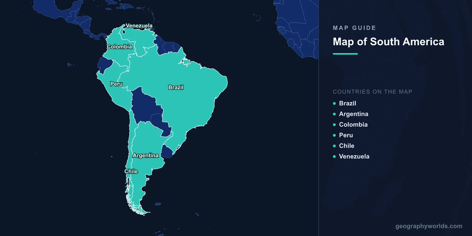
South America is the world's fourth-largest continent, covering 17.84 million km² (6.89 million sq mi) and home to about 434 million people across 12 sovereign countries. The continent stretches from Colombia at roughly 12°N down to Cape Horn, Chile at 55.9°S, and from the Pacific coast of Peru (81°W) to the Atlantic coast of Brazil (34.8°W). On the map, three giant features dominate: the Andes running the full western edge, the Amazon Basin across the north-center, and the Brazilian Highlands in the east.
Where South America Sits on the Map
South America is bordered by the Caribbean Sea and the Atlantic Ocean to the north and east, the Pacific Ocean to the west, and the Drake Passage to the south, the stormy 800 km channel separating the continent from Antarctica. It connects to North America through the narrow Isthmus of Panama, the only land bridge between the two Americas. Most of the continent lies in the Southern Hemisphere, so its seasons are reversed compared with Europe and North America: winter falls in June–August and summer in December–February.
The continent is remarkably compact in shape, tapering from a broad tropical north to a thin, glacier-fringed southern point. Because so much of it sits near the equator, South America is one of the warmest and wettest continents on Earth, yet it also contains some of the driest and coldest inhabited places anywhere.

All 12 Countries of South America and Their Capitals
South America has exactly 12 sovereign nations, plus French Guiana, an overseas department of France and the continent's only non-sovereign territory. Here is the complete list, from largest to smallest by area:
- Brazil — capital Brasília; 8.51 million km²; ~216 million people; the largest country, covering the Amazon basin.
- Argentina — capital Buenos Aires; 2.78 million km²; ~46 million; spans Patagonia to the subtropics.
- Peru — capital Lima; 1.28 million km²; ~34 million; Andes highlands and Amazon lowlands.
- Colombia — capital Bogotá; 1.14 million km²; ~52 million; the only country with both Caribbean and Pacific coasts.
- Bolivia — administrative capital La Paz, constitutional capital Sucre; 1.10 million km²; ~12 million; landlocked Andean nation.
- Venezuela — capital Caracas; 916,445 km²; ~28 million; home to Angel Falls and Lake Maracaibo.
- Chile — capital Santiago; 756,102 km²; ~19.5 million; a sliver 4,270 km long but only about 177 km wide.
- Paraguay — capital Asunción; 406,752 km²; ~7 million; landlocked, split by the Paraguay River.
- Ecuador — capital Quito; 283,561 km²; ~18 million; straddles the equator and owns the Galápagos Islands.
- Guyana — capital Georgetown; 214,969 km²; ~800,000; English-speaking, on the Caribbean rim.
- Uruguay — capital Montevideo; 176,215 km²; ~3.4 million; rolling grassland and Atlantic beaches.
- Suriname — capital Paramaribo; 163,820 km²; ~620,000; the smallest sovereign state, Dutch-speaking.
Brazil alone accounts for nearly half the continent's land area and population. Spanish is the most widely spoken language, official in nine countries, while Portuguese dominates because of Brazil's size. Guyana (English), Suriname (Dutch), and French Guiana (French) reflect the region's colonial mosaic.
The Three Great Landform Regions
Reading the physical map of South America is easiest if you break it into three building blocks. The Andes Mountains form a continuous spine 7,000 km long down the western edge, the longest continental mountain range on Earth. Its highest peak, Aconcagua in Argentina, rises to 6,961 m, the tallest summit outside Asia. The Andes also hold Ojos del Salado (6,893 m), the highest active volcano in the world.
The Amazon Basin fills the north-center, draining 7.05 million km² and holding the planet's largest tropical rainforest, roughly 5.5 million km², estimated to contain 10% of all known species. East of the basin lie the older, eroded Brazilian and Guiana Highlands, ancient plateaus that contrast with the young, jagged Andes. Between and around these blocks spread vast lowland plains, including the Argentine Pampas, the Venezuelan and Colombian Llanos, and the Pantanal, the world's largest tropical wetland at 150,000–195,000 km².
Rivers, Lakes, and Coasts
South America's river systems are among the mightiest anywhere. The list of headline waterways every geography student should know:
- Amazon River: about 6,992 km long with the greatest discharge of any river, roughly 20% of all river water reaching the ocean; its mouth is 330 km wide and ships can sail 3,700 km upstream to Iquitos.
- Paraná River: 4,880 km; joins the Uruguay River to form the Río de la Plata estuary by Buenos Aires.
- Lake Titicaca: 8,372 km²; the highest navigable lake on Earth at 3,812 m, on the Peru–Bolivia border.
- Lake Maracaibo: 13,210 km²; one of the oldest lakes on the planet, in Venezuela.
- Angel Falls: 979 m; the world's highest uninterrupted waterfall, in Venezuela.
- Iguazú Falls: a system of 275 cascades spanning 2.7 km on the Argentina–Brazil border.
Climate Zones Across the Continent
Because South America stretches across more than 65 degrees of latitude, it samples nearly every climate on Earth:
- Tropical: the Amazon Basin and northern coasts, hot and humid year-round with 2,000–3,000 mm of annual rain.
- Arid: the Atacama Desert of northern Chile, the driest non-polar desert on Earth, where some weather stations have never recorded rainfall.
- Temperate: southern Brazil, Uruguay, and the Argentine Pampas, with four distinct seasons.
- Highland: the Andean altiplano above 3,000 m, cold and thin-aired despite a tropical latitude.
- Sub-polar: Tierra del Fuego at the southern tip, cold, windswept, and near-Antarctic, where Patagonian winds can exceed 160 km/h.
Key Facts
- Area: 17.84 million km² (6.89 million sq mi), the fourth-largest continent.
- Population: about 434 million (2024).
- Countries: 12 sovereign nations, plus French Guiana.
- Highest point: Aconcagua, 6,961 m, in Argentina.
- Longest river: the Amazon, about 6,992 km, with the greatest discharge of any river.
- Largest country: Brazil, fifth-largest in the world by both area and population.
- Driest place: the Atacama Desert, the driest non-polar desert on Earth.
Frequently Asked Questions
How many countries are in South America?
There are 12 sovereign countries:
- Brazil
- Argentina
- Peru
- Colombia
- Bolivia
- Venezuela
- Chile
- Paraguay
- Ecuador
- Guyana
- Uruguay
- Suriname
French Guiana is part of South America too, but it is an overseas department of France rather than an independent nation.
What is the largest country in South America?
Brazil is by far the largest, covering 8.51 million km² — nearly half the continent — and home to about 216 million people. It borders every South American country except Chile and Ecuador.
What are the main physical features of South America?
The three dominant features are the Andes Mountains along the western coast, the Amazon Basin and rainforest in the north-center, and the Brazilian Highlands in the east. The continent also includes the Atacama Desert, Patagonia, the Pantanal wetlands, and Angel Falls.
Why are South America's seasons reversed?
Most of the continent lies in the Southern Hemisphere, so the calendar of seasons is flipped relative to the north. June through August is winter, while December through February is summer, which is why ski resorts in Chile and Argentina open in the middle of the year.
Test Your Geography Knowledge!
Think you know your maps? Try our interactive geography games!
Play Geography Games →