

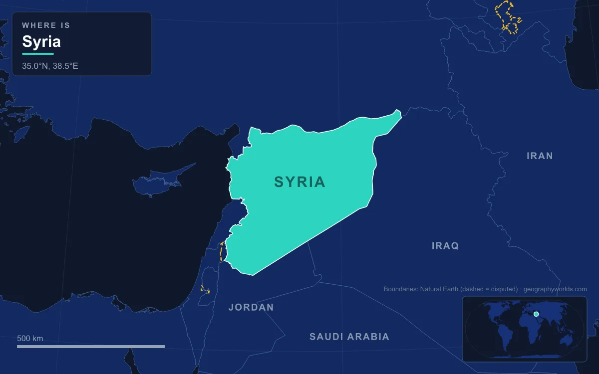
Syria lies in West Asia at the eastern end of the Mediterranean Sea, covering 185,180 km² between Turkey to the north, Iraq to the east, Jordan to the south, and Israel and Lebanon to the southwest, with a 193 km coastline. Its land divides into a narrow coastal plain; a double belt of western mountains, the Jabal an-Nusayriyah (the Syrian Coastal Mountain Range) and the Anti-Lebanon, with the Orontes valley between them; the volcanic Hauran plateau and Jabal al-Druze in the south; and a vast eastern plateau of steppe and the Syrian Desert, cut diagonally by the Euphrates. The highest point is Mount Hermon, 2,814 m, on the Lebanese border; the main rivers are the Euphrates, which supplies more than 80 percent of Syria's water, its tributaries the Khabur and the Balikh, the north-flowing Orontes and the Barada of Damascus. About three-fifths of the country gets less than 250 mm of rain a year, and that single fact explains where Syria's roughly 26 million people live, farm and build their cities.
Latakia, Tartus and the Rain-Catching Jabal an-Nusayriyah
From the Turkish border south to Lebanon, the Mediterranean shore is a thin coastal plain of sand dunes, broken only where spurs of the mountains run down to the sea as headlands. This strip is the only part of Syria that faces the open sea, and it holds the country's two ports, Latakia and Tartus. Latakia, the principal port, had an estimated 709,000 people in 2023, a number swollen by people displaced from inland during the civil war. Its climate is Mediterranean: December and January each bring around 160 mm of rain, while July averages about 1 mm.
That rain is the work of the Jabal an-Nusayriyah, the ridge that parallels the coast at an average height of just over 1,200 m and peaks at Nabi Yunis, about 1,575 m. Moist westerly winds rise against its western face and drop between 750 and 1,200 mm of rain a year on the coastal zone, most of it between November and May. The western slopes are therefore greener and more densely settled than the eastern ones, which receive only hot, dry winds off the interior.
The Homs Gap and the Orontes: Syria's Western Farming Corridor
The coastal range does not quite reach the Anti-Lebanon. Just north of the Lebanese border it ends, leaving a low opening called the Homs Gap, where the small Nahr al-Kabir runs down to the sea at Arida. It is the only large crossing through the western mountains that stays open all year, and for centuries traders and armies used it to move between the coast and the interior. The highway and railway from Homs to the Lebanese port of Tripoli still run through it, and the Crusader castle of Krak des Chevaliers stands above it.
Rain clouds from the Mediterranean also slip through the gap, which is why Homs and, in some years, the steppe east of it get more rain than places farther south. Homs sits at 501 m on the Orontes, 162 km north of Damascus, and before the civil war it was an industrial city of at least 652,609 people (2004), Syria's third largest. The Orontes itself is 571 km long. It rises in Lebanon's Bekaa Valley and flows north, against the grain of most rivers in the region, through Homs and Hama and on to the sea near Samandağ in Turkey.
North of Hama the river enters the Ghab, a trench 63 km long and about 12 km wide between the coastal range and the Jabal az-Zawiyah. For centuries the Orontes kept it a swamp. The Ghab project, begun in 1953, built barrages and drainage canals and turned about 41,000 hectares into irrigated farmland. Because the coastal range captures the Mediterranean rain, the Ghab itself is relatively dry, and its farms depend on the river and on springs.
Hama shows how people lifted that river water before engines. Seventeen norias, giant wooden water wheels, survive along the Orontes in the city. The current turns them, and buckets on the rim lift water into aqueducts that once fed houses, gardens and fields. The largest, the 21 m Noria al-Muhammadiya of 1361, was the tallest water wheel in the world for nearly 500 years.

Mount Hermon, the Barada and the Ghouta Oasis of Damascus
South of the Homs Gap the Anti-Lebanon Mountains rise to more than 2,700 m along the Syrian–Lebanese frontier, and at their southern end stands Mount Hermon, the Jabal ash-Shaykh. Its summit, 2,814 m, straddles the border with Lebanon and is the highest point in Syria. The Hermon range runs about 70 km along the boundary and covers roughly 700 km², of which about 70 km² on its southern slopes have long been under Israeli control. The summit lies in the United Nations buffer zone between Syrian territory and the Israeli-occupied part of the Golan Heights, which Israel has held since 1967 and Syria claims; Israeli forces also took the summit itself on 8 December 2024, the day the Assad government fell. The lowest ground in Syria's internationally recognised territory, about 200 m below sea level, lies in the same disputed area near the Sea of Galilee.
Snow covers its three summits for much of the year, and meltwater sinks through its limestone to springs that feed the Jordan River system.

Damascus lies east of these mountains on a plateau 680 m above sea level, about 80 km from the sea, and it should barely be habitable. The Anti-Lebanon blocks the Mediterranean rain, so the capital sits in a rain shadow with an arid climate and usually less than 200 mm of rain a year; daily mean temperatures run from about 5 °C in January to 29 °C in July and August. What made the city possible is the Barada, a short river that rises in the Anti-Lebanon, flows past Mount Qasioun and then fans out through seven branches before disappearing into the desert. Its water created the Ghouta, an oasis of orchards, gardens and vineyards that once stretched up to 10 km from the walls of the Old City and covered some 370 km². Since the 1980s suburbs, highways and war have eaten into it.
South of Damascus the land opens into the Hauran, a rolling basalt plateau dotted with volcanic cones, some over 900 m high, once fertile and still farmed for grain. Springs feeding the upper Yarmouk River are diverted to irrigate it. Beyond it rises Jabal al-Druze, also called Jabal al-Arab, a volcanic upland in Suwayda Governorate that is part of the Harrat al-Shamah lava field stretching south into Saudi Arabia. Its height gives it more rain than the plains around it, and it is home to Syria's Druze community, the country's only Druze-majority governorate.
Palmyra's Efqa Spring and the Badiyat al-Sham
East of the western highlands, Syria becomes the Badiyat al-Sham, the Syrian Desert, which covers about 55 percent of the country. It is mostly open rock and gravel pavement cut by dry wadis rather than sand dunes. A low chain of ridges, the Jabal ar-Ruwaq, Jabal Abu Rujmayn and Jebel Bishri, runs northeast from Jabal al-Arab to the Euphrates. South of them lies the barren Hamad; north of the Jabal ar-Ruwaq and east of Homs is the hard-packed Homs Desert. Rainfall in the southeast drops below 100 mm a year and varies wildly from one year to the next, July maximums often pass 45 °C, and sandstorms in February and May strip grazing land.
Settlement here depends on single water sources, and Palmyra is the clearest case. The ancient city grew around the Efqa spring, an artesian source first developed between 4000 and 2000 BCE, which flows out of the limestone of al-Mintar mountain through nine hand-dug wells and a 400 m underground channel. Its water made Palmyra a caravan stop between the Mediterranean and Mesopotamia, and that trade paid for the Temple of Bel. The spring went dry in 1994 through drought, over-pumping and neglect; after restoration it was flowing again by 2019, watering about 420 hectares of date palms and olives around the modern town of Tadmur.
The Euphrates, Lake Assad and the Jazira Breadbasket
The Euphrates enters Syria from Turkey beside Jarabulus and crosses the country diagonally for about 710 km before passing into Iraq near Abu Kamal, falling only 163 m on the way. Its most important Syrian tributaries join from the left bank: the Balikh and the Khabur, small perennial rivers that rise near the Turkish border. The Khabur, the larger of the two, draws most of its water from karstic springs around Ras al-Ayn and meets the Euphrates near Busayrah. On the right bank, the tributaries are mostly seasonal wadis draining the desert.
In 1973 Syria finished the Tabqa Dam, also called the Euphrates Dam, 40 km upstream of Raqqa. Built from 1968 with Soviet help, it is 60 m high and 4.5 km long, the largest dam in the country. When Syria reduced the river's flow in 1974 to fill the reservoir, downstream Iraq protested, and the dispute was settled only through Saudi and Soviet mediation. The reservoir, Euphrates Lake, formerly Lake Assad, is about 80 km long, has a maximum surface area given as 525 to 610 km² and can hold up to 11.7 km³, making it Syria's largest lake. Neither dam nor lake has reached its planned 880 MW and 640,000 irrigated hectares (by 2000 only 124,000 hectares, 19 percent, were watered), but its canals water farms on both banks and it supplies drinking water to Aleppo, Syria's second-largest city with about 2.1 million people in 2021. Aleppo itself lies on the steppe in the rain shadow of the coastal mountains, with about 329 mm of rain a year.
Northeast of the Euphrates lies the Jazira, the plain that al-Hasakah Governorate shares with Iraq and Turkey and that is described as Syria's breadbasket. Across the Khabur basin, rain falls from over 400 mm near the Turkish border to under 200 mm farther south, so northern fields grow rain-fed wheat and southern ones depend on the river. Irrigation schemes in the 1960s and 1970s expanded cereal and cotton output, and oil and gas fields in the far northeast added a second economy. About a quarter of Syria's land was arable in 2005.
Syria's 2,253 km of land boundaries mostly ignore these natural regions: the Turkish border runs along the northern edge of the Jazira, while the Iraqi one crosses the desert and the Euphrates valley.
For how the steppe and desert work in more detail, see the guide to the Syrian Desert and the Euphrates river guide, and for how these landscapes translate into population, compare Damascus, Aleppo, Homs and Latakia in the list of the largest cities in Syria.