

The capital of Libya is Tripoli, a Mediterranean port in the far north-west of the country, on a rocky point of land that forms a natural bay, not far from the Tunisian border. Estimates for 2021 put the city's population at about 3.2 million, making it Libya's largest city, and it holds the country's main port, its central bank and the University of Tripoli. Tripoli has been continuously inhabited since Phoenician traders founded it in the 7th century BC, and its old town still packs Roman, Ottoman and Italian layers into a few hundred metres. One caveat matters today: since 2014 Libya has had rival authorities, and while the internationally recognised Government of National Unity sits in Tripoli, a competing government backed by the House of Representatives operates in the east.
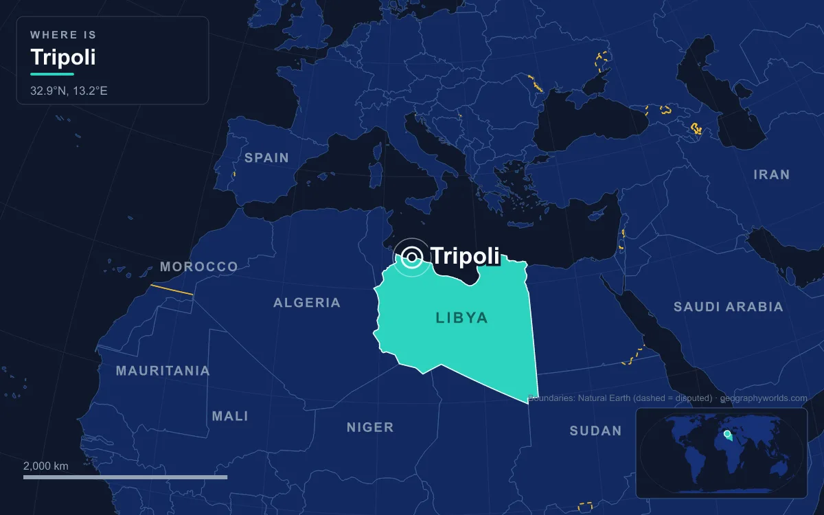
The easiest way to understand how Tripoli became the capital is to walk it, starting on the waterfront and working inland through three thousand years of rulers.
The Red Castle and the Old Shoreline
Begin at the Red Castle, As-Saraya al-Hamra, the fortress that anchors the whole city. It forms an irregular square with sides between 90 and 140 metres long and covers about 13,000 square metres. Excavations have found Roman remains inside, and its origins may go back to the Phoenician colony of Oea. Every power that held Tripoli held this castle: Vandals, Byzantines, the armies of Amr ibn al-As in 642 or 643, Fatimids, Normans, Almohads and Hafsids.
Much of what stands today dates from after 1510, when Spain captured the city, and from 1530 to 1551, when the city was assigned to the Knights of St John. The Knights are said to have painted the castle red ochre, which gave it its name. After the Ottomans, led by Turgut Reis, took the city in 1551, the castle became the governor's residence, and under the Karamanli dynasty, which ruled Tripoli with near independence from 1711 to 1835, it was the seat of power. In 1919 the Italians turned it into Libya's first museum, and it still houses the Red Castle Museum and, since 1952, the Libyan Department of Archaeology.
The castle once stood directly on the sea. In the 1970s a seafront highway, Al-Shat Road, cut it off from the water and left behind the Saraya Lake, which now reflects its walls. Standing here you are looking at the reason the Phoenicians came: a sheltered natural harbour with a small, defensible peninsula on its western side.
Martyrs' Square, Once Piazza Italia and Green Square
Step off the castle's south-eastern side and you are in Martyrs' Square, the city's main plaza. Its names are a history lesson in themselves. The Italians laid it out on the site of the old bread market and called it Piazza Italia, expanding it several times in the 1930s. After independence in 1951 it became Independence Square. After Muammar Gaddafi's coup of 1 September 1969 it was renamed Green Square, to mark the political philosophy of his Green Book, and it hosted his rallies for four decades. On the night of 21 to 22 August 2011, rebel fighters took the square and renamed it Martyrs' Square, and on Eid al-Fitr, 31 August, tens of thousands of residents gathered here to celebrate the end of his rule.
Gaddafi's government changed the square's shape as well as its name. The Royal Miramare Theatre, which faced the castle, was demolished to create space for mass demonstrations. Several wide avenues branch out from the square: Omar Mukhtar Avenue, 24 December Avenue, Mizran Street and Independence Street, which leads to the former palace of King Idris I.
Through Bab al-Bahr into the Pentagonal Medina
North-west of the castle lies the Medina, the old walled city. Its outline is a rough pentagon, fixed in the 16th century when the Ottomans rebuilt the walls. There were at least three gates: Bab Hawwara to the south-east, Bab Zenata to the west, and Bab al-Bahr, the Sea Gate, to the north. Only stretches of the walls survive on the south-western and south-eastern sides, but the street pattern inside is still largely Ottoman and Karamanli.
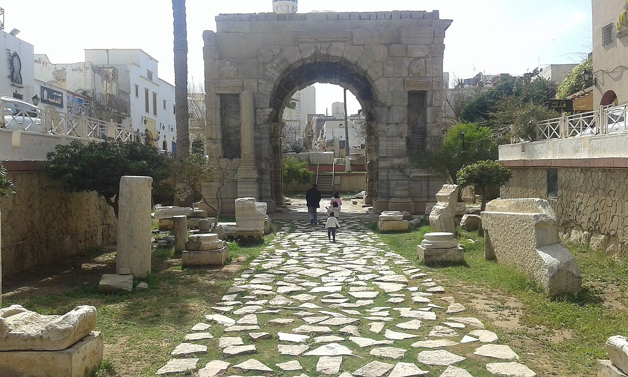
Near the north-eastern entrance stands the oldest monument you will pass: the Arch of Marcus Aurelius, a four-way marble arch erected in AD 165 by a local magistrate, Gaius Calpurnius Celsus, to celebrate Roman victories over the Parthians. It is the only substantial Roman structure left in the city. Because Tripoli never stopped being lived in, unlike its sister towns Sabratha and Leptis Magna, later builders either quarried Roman Oea for stone or built on top of it. The city's Greek name, Trípolis or "three cities", comes from that trio of Oea, Sabratha and Leptis Magna, and only Oea survived antiquity as a living town.
Near the arch is the Gurgi Mosque, built in 1834 for the naval captain Mustafa Gurgi, whose family tombs lie in its antechamber. A short walk through the Bab al-Bahr quarter brings you to the Mosque of Darghut Pasha, completed in 1556 by Turgut Reis himself. Turgut was killed during the Ottoman siege of Malta in 1565, and his body was brought back to be buried here, next to the palace he had built, which has since vanished. Deeper in, near the castle, the Mosque of Ahmad Pasha al-Karamanli, finished around 1738, anchors the Souq al-Mushir, and the Ottoman clock tower, 18 metres tall and built between 1866 and 1870, is still one of the city's landmarks. The oldest Islamic building of all, the al-Naqah Mosque, may date to 973.
These streets also explain Tripoli's reputation on the Barbary Coast. Under Ottoman and Karamanli rule the city was a corsair base, and in 1801 the pasha's demand for more tribute from the United States started the First Barbary War. In 1803 the US frigate Philadelphia ran aground in Tripoli harbour and its crew were held in the city until the 1805 treaty, which cost Washington $60,000 in ransom.
Omar Mukhtar Avenue and the Italian City of 1911 to 1943
Leave the Medina southward and the streets straighten. Italy declared war on the Ottoman Empire on 29 September 1911 and occupied Tripoli, and over the next three decades it built a new colonial city beside the old one. Omar Mukhtar Avenue, one of the longest in North Africa, runs out from Martyrs' Square, and Italianate buildings such as the Galleria De Bono date from these years. In 1927 the Italians founded the Tripoli International Fair on this avenue, and it is still described as the oldest trade fair in Africa. They also built a sewage system and a modern hospital in the early 1920s, and in 1923 an air base at Mellaha that is now Mitiga International Airport.
In 1934 Italy merged Tripolitania, Cyrenaica and Fezzan into one colony called Libya, with Tripoli as its capital, and by 1938 the city had 108,240 inhabitants, 39,096 of them Italian. A short walk away, on Algeria Square, stands the most striking survivor of that era: the former Tripoli Cathedral, designed by Saffo Panteri and consecrated in November 1928, with a dome rising 46 metres and a 60-metre bell tower. Around 1970 it was converted into the Algeria Square Mosque.

British Eighth Army troops entered Tripoli on 23 January 1943, and Britain governed it until Libya became independent on 24 December 1951. Under the 1947 peace treaty Italy gave up all claims to the country.
From Bab al-Aziziya to Mitiga: Tripoli's Contested Role as Capital
The last stretch of the walk leads out to the site of Bab al-Aziziya, Gaddafi's fortified compound, and to Mitiga airport. Both explain why Tripoli's status as capital has never been as simple as the atlas suggests. Under King Idris, the rivalry between Tripolitania and Cyrenaica was handled by having Tripoli and Benghazi, more than 1,000 kilometres apart, alternate as capital every two years. Gaddafi made Tripoli his base but, in a decentralisation drive of September 1988, moved most ministries out of it, several to his birthplace, Sirte. That is why Tripoli has sometimes been called the country's de jure capital.
The city has been bombed twice in living memory: by the United States in Operation El Dorado Canyon on 15 April 1986, and during the foreign military intervention that began on 19 March 2011 to enforce a UN no-fly zone. Rebel fighters reached the capital on 21 August 2011, and on 1 September Gaddafi declared in a radio address that he had moved the capital to Sirte. After the second civil war broke out in 2014, the newly elected House of Representatives relocated to Tobruk while a rival parliament stayed in Tripoli. A 2020 ceasefire led to a Government of National Unity based in Tripoli, but in March 2022 the House of Representatives backed a rival Government of National Stability, and the two have operated in parallel ever since. The international community continues to recognise the Tripoli-based unity government as Libya's legitimate government. Armed clashes in the city in 2022 and 2023 are a reminder that the question is not settled.
Tripoli's water comes from far away as well: the Great Man-Made River, begun in 1982, pipes groundwater from beneath the desert to the coastal cities. The capital sits on the thin, habitable fringe of a country that is almost 1.8 million square kilometres in size and mostly desert. To see how that fringe fits into the rest of the country, read our Libya country guide, which covers the regions that have competed with Tripoli for power.
Quick Facts About Tripoli
- Country: Libya
- Continent: Africa (North Africa)
- Country population: approximately 7.5 million
- Capital city status: Tripoli is the capital of Libya, the seat of national government, and the location of foreign embassies, parliament, and the head of state's official residence.
Frequently Asked Questions
What is the capital of Libya?
The capital of Libya is Tripoli. Tripoli is the seat of national government, hosts most foreign embassies and consulates, and is typically where the head of state and parliament are located.
What continent is Tripoli in?
Tripoli, the capital of Libya, is located in Africa, in the North Africa region. As Libya's capital, Tripoli serves as the country's primary connection to the broader African political, economic, and cultural sphere.
Why is Tripoli the capital of Libya?
Tripoli was chosen as the capital of Libya for reasons that typically combine geography, history, and politics. Capital city selections often reflect a desire for centrality (being accessible from across the country), historical importance (being a longstanding seat of government or culture), or neutrality (being acceptable to multiple regions or ethnic groups within the country). The specific reasons for Tripoli's designation are detailed in the city's history above.
What is Tripoli known for?
As the capital of Libya, Tripoli is best known for housing the country's central government institutions — parliament, presidential or royal residences, supreme court, and key ministries. It is also typically a major cultural and economic center within Libya, hosting national museums, embassies, and signature monuments. The introduction and history sections above provide detailed coverage of the city's specific notable institutions and landmarks.
Related Pages
- Libya Country Guide — full geography, climate, economy, and culture overview
- Flag of Libya — meaning, history, and design of Libya's national flag