
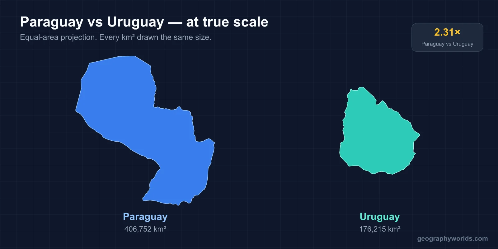
Paraguay is 2.3 times the size of Uruguay — 406,752 km² against 176,215 km² — and has roughly twice the population, 7.1 million to 3.4 million. The difference that shapes everything else, though, is water: Uruguay sits on the Atlantic and the Río de la Plata with about 660 km of coast, while Paraguay is one of only two landlocked countries in South America and reaches the ocean only by barge, down more than 1,500 km of river.
One Country Faces the Atlantic, the Other Has No Coast at All
Uruguay's entire southern and eastern edge is shoreline. Montevideo, Punta del Este, Colonia and Piriápolis all sit on it, and the country's trade, tourism and settlement history all follow that line. The Río de la Plata estuary — the widest river mouth in the world at around 220 km across — separates Uruguay from Argentina and gives Montevideo a deepwater port that has been contested since the Spanish built a fortress there in 1724 specifically to block Portuguese expansion from Colonia do Sacramento.
Paraguay has no coast. Along with Bolivia it is one of the continent's two landlocked states, and its access to world markets runs through the Paraguay-Paraná waterway, the Hidrovía, which flows south into the Río de la Plata and out past Buenos Aires and Montevideo. That dependence has a visible consequence: Paraguay operates one of the largest river barge fleets on Earth, routinely ranked behind only the United States and China, because barges are the country's substitute for ports. Landlocked status also explains why Paraguay's second city, Ciudad del Este, grew up on the Brazilian border rather than anywhere near the capital.
Comparing the Land: More Area, Less Variety of Terrain
| Feature | Uruguay | Paraguay |
|---|---|---|
| Area | 176,215 km² | 406,752 km² |
| Coastline | about 660 km | none (landlocked) |
| Land borders | Argentina, Brazil | Argentina, Bolivia, Brazil |
| Highest point | Cerro Catedral, 514 m | Cerro Pero, about 842 m |
| Dominant landscape | rolling grassland (cuchillas), fertile coastal lowland | wooded hills and plains east of the Paraguay River; Gran Chaco west |
Uruguay is the flattest country in South America by a wide margin. Cerro Catedral, at 514 m, is the lowest national high point on the continent, and the landscape barely deviates from gently rolling grassland — the southern extension of the Pampas, known locally as the cuchillas. There is no mountain range, no desert and no rainforest anywhere in the country. That uniformity is the reason nearly all of Uruguay is usable farmland and why the country supports a beef industry out of all proportion to its size.
Paraguay covers more than twice the ground but is far less uniform, and much of that extra territory is the least hospitable land in either country.
Paraguay's East-West Split Has No Uruguayan Equivalent
The Paraguay River cuts the country almost in half, and the two halves are barely the same place. The Región Oriental in the east makes up roughly 39 per cent of the land area and holds around 97 per cent of the population — well-watered, subtropical, forested originally with Atlantic Forest, and now largely converted to soy and cattle. Asunción, Ciudad del Este and Encarnación are all there.
West of the river is the Región Occidental, the Paraguayan Gran Chaco: about 60 per cent of the national territory and under 3 per cent of its people. It is a flat, hot, thorn-scrub plain that floods in the wet season and bakes dry in the rest, with cattle ranches, Mennonite colonies around Filadelfia established from the 1920s, and some of the last isolated Indigenous groups on the continent. Paraguay fought the Chaco War against Bolivia from 1932 to 1935 over this region and won most of the disputed ground.
Uruguay has nothing comparable. Its internal variation is a matter of degree — more forestry in the north, more dairy near Montevideo — not two regions with different climates and settlement patterns. The contrast is set out in more depth in the guide to Paraguay's geography.
Where the People Are
| Metric | Uruguay | Paraguay |
|---|---|---|
| Population | 3.4 million | 7.1 million |
| Density | 19.2 per km² | 17.4 per km² |
| Capital | Montevideo (founded 1724) | Asunción (founded 1537) |
The two density figures are nearly identical, which tells you almost nothing, because Paraguay's average spreads its people across a Chaco that is essentially empty. Adjust for that and the eastern half of Paraguay is considerably more crowded than Uruguay.
Both countries are dominated by their capitals. Montevideo's metropolitan area holds well over half of all Uruguayans, one of the highest capital concentrations anywhere. Asunción's metro region is larger in absolute terms — roughly 2.3 million — but accounts for a smaller share of the national total, because Paraguay has a real rural population and a second economic pole at Ciudad del Este on the Paraná.
Asunción is by far the older city. Founded in 1537 on the Paraguay River, it earned the name Madre de Ciudades — Mother of Cities — because expeditions launched from it went on to found Santa Fe, Corrientes, Santa Cruz de la Sierra and, in 1580, the second and permanent founding of Buenos Aires. Montevideo came nearly two centuries later, and as a military installation rather than a base for exploration. More on the older of the two is in the profile of Asunción.
Guaraní Is the Difference That Defines Paraguay
| Aspect | Uruguay | Paraguay |
|---|---|---|
| Official languages | Spanish | Spanish and Guaraní |
| Currency | Uruguayan peso (UYU) | Paraguayan guaraní (PYG) |
Paraguay is the only country in the Americas where an Indigenous language is spoken by a majority of people who are not themselves Indigenous. Guaraní is used by something close to 90 per cent of the population, in the street and at home as much as in ceremony, and it has been co-official with Spanish since the 1992 constitution. Most Paraguayans move between the two languages continuously, a blend informally called jopará. The national currency is itself named for the language.
Uruguay has no equivalent. Spanish is the sole official language, and the Indigenous Charrúa population was effectively destroyed in the nineteenth century, leaving no surviving language community. The only significant linguistic variation is along the Brazilian border, where a Spanish-Portuguese contact variety is spoken in towns such as Rivera and Artigas.
Frost-Free Pampas Against the Hottest Corner of the Continent
Uruguay's climate is warm temperate and unusually even. It has four genuine seasons, rainfall spread fairly uniformly through the year at roughly 1,000 to 1,300 mm, and hard freezes that are close to unknown at sea level. The pampero, a cold southwesterly off the Argentine plains, brings the sharpest drops. There is no dry season and no monsoon, which makes Uruguay one of the most agriculturally predictable countries in South America.
Paraguay runs from subtropical to semi-arid across its own width. The east receives 1,500 mm or more a year and stays humid; the western Chaco can get under 500 mm and is the hottest place on the continent, with temperatures recorded above 45°C. Summers in Asunción are heavier and more humid than anything Uruguay experiences, and the Chaco's swing between flood and drought is far wider than Uruguay's mild seasonal cycle.
Two Renewable Grids, Built in Opposite Ways
Both countries generate almost all of their electricity without fossil fuels, and neither did it the same way.
Paraguay's answer is hydropower on a scale nothing else in the region matches. The Itaipú Dam on the Paraná, shared with Brazil and completed in the 1980s, has an installed capacity of about 14,000 MW and held the record for annual generation until the Three Gorges Dam overtook it. Paraguay owns half the output and consumes only a fraction of it, selling the surplus to Brazil; a second binational plant, Yacyretá, is shared with Argentina. The result is a country running on effectively 100 per cent renewable electricity and exporting power as a major source of national revenue.
Uruguay built something less obvious. It has hydro too — the Salto Grande dam is shared with Argentina — but during the 2010s it added wind at remarkable speed, taking it from almost nothing to roughly a third of generation, alongside biomass and solar. In good years Uruguay's grid runs at 90 per cent or more renewable, and it did that without a single large new dam, on a flat, windy, treeless landscape that turns out to suit turbines well.
Beef, Soy and Software
Uruguay sells beef, and more of it per person than almost any country on Earth; cattle outnumber Uruguayans roughly three or four to one. Soy, rice, dairy and wool follow, and forestry has grown into a major export through eucalyptus plantations feeding large pulp mills. The genuinely distinctive piece is services: Uruguay has become a notable software and fintech exporter for its size, and Punta del Este draws high-spending seasonal tourism from Argentina and Brazil. Uruguay's GDP per capita is the highest in South America.
Paraguay's export list is shorter and more concentrated. It is one of the world's largest soybean exporters despite its size, backed by beef, and by electricity from Itaipú and Yacyretá. A great deal of economic activity also runs through cross-border commerce at Ciudad del Este, opposite Foz do Iguaçu. Yerba mate is native to the region and the species is named Ilex paraguariensis for it, though the two countries drink it differently — Uruguay hot, Paraguay cold as tereré, which suits the Chaco heat.
The War That Still Separates Them
Any comparison of these two countries eventually runs into the War of the Triple Alliance, fought from 1864 to 1870, in which Paraguay faced Brazil, Argentina and Uruguay simultaneously. Paraguay lost catastrophically: a large share of its population died, credible estimates of male mortality run extraordinarily high, and it surrendered substantial territory to Brazil and Argentina. The country was still recovering demographically decades later.
Uruguay, which had entered on the winning side after its own internal conflict drew in its neighbours, emerged intact and continued a very different trajectory — early welfare legislation under José Batlle y Ordóñez in the 1900s, and later the first FIFA World Cup, which Uruguay hosted and won in 1930. The divergence in wealth and institutional depth between the two countries has its roots in that century.
They are close partners now. Both were founding members of Mercosur, established by the 1991 Treaty of Asunción — signed, as it happens, in the Paraguayan capital.
The Numbers in One Place
- Area: 176,215 km² vs 406,752 km² — Paraguay is 2.3 times larger
- Population: 3.4 million vs 7.1 million — Paraguay is about 2.1 times more populous
- Sea access: 660 km of Atlantic and estuary coast vs landlocked, river access only
- Capitals: Montevideo (1724) vs Asunción (1537)
- Highest point: Cerro Catedral 514 m vs Cerro Pero about 842 m
- Official languages: Spanish vs Spanish and Guaraní
- Currency: Uruguayan peso vs Paraguayan guaraní
- Climate: warm temperate, near frost-free vs subtropical east, semi-arid and very hot Chaco west
- Electricity: hydro plus fast-built wind vs binational mega-dams and power exports
- Main exports: beef, soy, pulp, software vs soy, beef, electricity
Picking Between Them
If you want the larger country, it is Paraguay, by a factor of more than two, with the more populous society and a far more dramatic internal contrast between its green east and its thorn-scrub west. If you want coastline, seasons that never bite, and the most compact and predictable landscape on the continent, that is Uruguay.
They are also not near-copies of one another in the way the shared suffix implies. Paraguay is bilingual to a degree no other American country matches and runs on exported hydroelectricity; Uruguay is almost entirely Spanish-speaking, has the continent's highest income per head, and built its recent energy story out of wind. Readers who came here for the smaller of the two often carry on to the overview of where Uruguay sits on the map and how its position between Argentina and Brazil has shaped it.