

Paraguay is a landlocked country of about 406,750 km² in the middle of South America, bordered by Argentina, Bolivia and Brazil. The Paraguay River splits it into two very different halves: the eastern Paraneña region, a country of low plateaus, hill ranges and river valleys where the great majority of Paraguayans live, and the western Chaco, a hot, flat plain that covers more than 60 percent of the land. The highest point is Cerro Tres Kandú, 842 m, in the Ybytyruzú hills of Guairá Department, and the lowest is about 46 m where the Paraguay River meets the Paraná. Those two rivers, together with the Pilcomayo on the Argentine border, are the country's main waterways, and the Paraná carries two giant binational hydroelectric dams, Itaipu and Yacyretá.
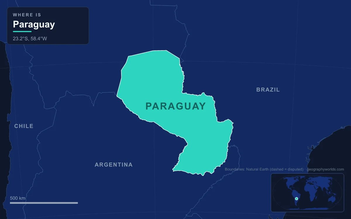
Paraguay has no coast and no peak above 1,000 m, so it is best understood through specific places rather than broad regions. Six of them explain most of the map: a hill, a lake, two rivers, a plain and a muddy confluence at the country's southern tip.
Cerro Tres Kandú and the Ybytyruzú Hills of Guairá
Paraguay's roof is modest. Cerro Tres Kandú, also listed as Cerro Peró, rises to 842 m (2,762 ft) in the municipality of General Eugenio Garay in Guairá Department, in a small range known as the Ybytyruzú. The range stands about 20 km east of Villarrica, the department capital, and its forested ridges are visible from the city. Because the summit commanded long views across the eastern lowlands, the Paraguayan armed forces and the national electricity company ANDE both placed radio repeaters on it; those installations are now abandoned.
The Ybytyruzú belongs to the hill country of eastern Paraguay, an extension of the plateau of southern Brazil. Its main ranges are the Cordillera de Amambay, which runs about 200 km along the Brazilian border in the north-east and averages 400 m, the Cordillera de Mbaracayú, which reaches 120 km east to the Paraná, and the Cordillera de Caaguazú, which runs south from the point where the other two meet and tops out at Cerro de San Joaquín, about 500 m. Below these ranges, about 80 percent of the eastern region lies under 300 m.

The plateau's western edge is an escarpment that falls from about 460 m in the north to about 180 m in the south. West of it the land steps down through the Northern Upland, the Central Hill Belt around Asunción and the Central Lowland, where small forested hills called islas de monte, "mountain islands", rise 6 to 9 m above the grass. They appear to be weathered remnants of the older rock farther east, and their edges are called costas, coasts, as if the grassland were a sea.
Ypacaraí Lake in the Asunción–Villarrica Graben
Paraguay's only lakes of any size lie in the Central Hill Belt, and the best known is Ypacaraí, about 50 km east of the capital. It sits in the western part of a tectonic trough called the Asunción–Sapucai–Villarrica graben, a block of crust that dropped between faults in the Mesozoic era. The lake is about 24 km long from north to south and 6 km wide, covering roughly 90 km². It is also remarkably shallow, with an average depth of about 1.7 m, and it drains north-west through the Salado River into the Paraguay.
Three towns ring the shore. San Bernardino, 48 km from Asunción, is nicknamed the "Summer City" for its lakeside resorts; Areguá, 31 km from the capital, is known for its pottery fairs; and the town of Ypacaraí has hosted a folk festival every September since 1971. The lake's original name was Tapycua. Its present name is usually translated as "holy lake" and is tied to a legend that the Franciscan missionary Luis de Bolaños blessed the water around 1600. A shallow lake surrounded by farms, suburbs and cattle has paid a price, however: algal blooms have turned the water green, and Ypacaraí is now described as the most polluted lake in the country, with swimming advised against.
The Paraguay River, Spine of a Divided Country
The river that gave the country its name rises south of Diamantino in the Brazilian state of Mato Grosso and runs about 2,621 km to its meeting with the Paraná north of the Argentine city of Corrientes. Along the way it passes through the Pantanal wetlands. It then forms the Brazil–Paraguay border from Puerto Bahía Negra south to the mouth of the Apa River, crosses the middle of Paraguay for about 400 km, and below Asunción forms the Argentine border for another 275 km.
Its basin covers roughly 1,095,000 km², and unlike the Paraná it has never been dammed for hydroelectric power. That makes it navigable for a very long distance, second on the continent only to the Amazon, and it is the main shipping corridor linking landlocked Paraguay and Bolivia to the Atlantic. Asunción, founded in August 1537 on its eastern bank near the mouth of the Pilcomayo, Concepción farther north and Formosa on the Argentine side are all river cities. The river also explains the human map: both halves of the country slope gently towards it, and the eastern bank holds almost all the people, while the western bank opens onto the Chaco.
Paraguay's borders are traced largely by water. The line with Argentina, agreed in 1876, follows the Pilcomayo, the Paraguay and the Paraná. The north-eastern frontier with Brazil, set in 1872, follows the Paraná, the ridges of the Amambay and the Apa. The Chaco boundary with Brazil along the upper Paraguay dates from 1927, and the line with Bolivia across the Chaco's low hills was fixed in 1938.
The Paraná at Itaipu and Yacyretá
The Paraná, at about 4,880 km the second-longest river in South America after the Amazon, forms Paraguay's eastern and southern edge. Paraguay and Brazil signed the Itaipu Treaty on 26 April 1973. In October 1978 engineers diverted the river so they could build on its dry bed, and the reservoir began filling on 13 October 1982, rising 100 m in two weeks. It drowned the Guaíra Falls, one of the largest waterfalls in the world, and the project displaced about 10,000 families. The first turbine started on 5 May 1984. With 20 units of 700 MW each, Itaipu has an installed capacity of 14,000 MW and set a world record of 103.1 TWh in 2016, a figure overtaken by China's Three Gorges Dam in 2020.
Half of the generators run at 50 Hz for Paraguay and half at 60 Hz for Brazil. Paraguay cannot use all of its share, so most of it flows to Brazil. Downstream, near Ayolas and about 260 km south-east of Asunción, the 808 m long Yacyretá Dam, shared with Argentina, blocks the Paraná at the Jasyretâ–Apipé rapids and can produce 3,100 MW. Its reservoir flooded much of Yacyretá Island.
Between the two dams the eastern plateau sheds its water into the Paraná through short, steep rivers. Near Ciudad del Este, the Monday River drops over Saltos del Monday, a waterfall about 45 m high and 120 m wide, set in one of the last patches of Alto Paraná Atlantic forest on the Paraguayan bank. The plateau here is also the wettest part of the country: Puerto Bertoni has recorded as much as 3,300 mm of rain in a year.
The Gran Chaco Between the Pilcomayo and the Bolivian Border
West of the Paraguay River lies the Chaco Boreal, Paraguay's share of the Gran Chaco, a plain of about one million square kilometres that also spreads into Bolivia, Argentina and Brazil. Its name comes from the Quechua word chaqu, "hunting land". In Paraguay the plain averages about 125 m above sea level and never rises above 300 m, tilting so gently eastward that rivers wander and spread rather than flow. Its departments of Presidente Hayes, Boquerón and Alto Paraguay cover about 60 percent of the national territory but hold less than 4 percent of the population.

The Chaco has two faces. Near the river, the Bajo Chaco or Humid Chaco is a land of palm savanna and swamps; the Estero Patiño, at about 1,500 km², is the largest swamp in Paraguay. The western three-quarters, the Alto Chaco or Dry Chaco along the Bolivian border, is the driest part of a region that receives only 500 to 1,000 mm of rain a year, falling mostly in summer, so areas that are dusty in winter become marsh after the storms. Its southern edge is the Pilcomayo, which rises near Lake Poopó in Bolivia and runs about 1,100 km to the Paraguay near Asunción. The river carries so much silt that it clogs its own bed and splits into northern and southern branches before reuniting downstream.
This dry plain was the prize in the Chaco War of 1932 to 1935, fought against Bolivia over land thought to be rich in oil. It is remembered as the "War of Thirst", and the peace treaty signed in Buenos Aires in July 1938 awarded Paraguay about three-quarters of the disputed Chaco. Settlement came later and slowly. German-speaking Mennonites, arriving from Canada in the 1920s and from the Soviet Union in the 1930s and after the Second World War, founded colonies such as Fernheim, whose centre is Filadelfia, and Neuland in the central Chaco. Ranching and soybean farming have since spread across the region, and between 2000 and 2019 the Paraguayan Chaco saw the most dramatic loss of dry forest of the three countries that share the Gran Chaco.
The Paraguay–Paraná Confluence at 46 Metres
Paraguay's lowest ground is its south-western corner, where the Paraguay River joins the Paraná opposite the Argentine province of Corrientes at about 46 m above sea level. The land leading to it is the Ñeembucú Plain, a swampy alluvial flat crossed by the Tebicuary River and broken only by rounded swells of land up to 3 m high. Here the two halves of the country finally meet, and the combined rivers flow on south through Argentina to the Río de la Plata and the Atlantic. This is the route that gives Paraguay its access to the ocean along a river corridor that also carries Brazilian, Bolivian and Argentine barge traffic.
These places show how small differences in height shape a whole country. Fewer than 800 m separate Tres Kandú from the confluence. Yet that gentle slope decides where rain falls and where it drains, where cities grew and where they did not, and why a country with no coast earns so much from water. The river frontier is set out in more detail in our guide to the countries that border Paraguay, the dam itself in our feature on the Itaipu Dam, and the riverbank capital in our profile of Asunción.