
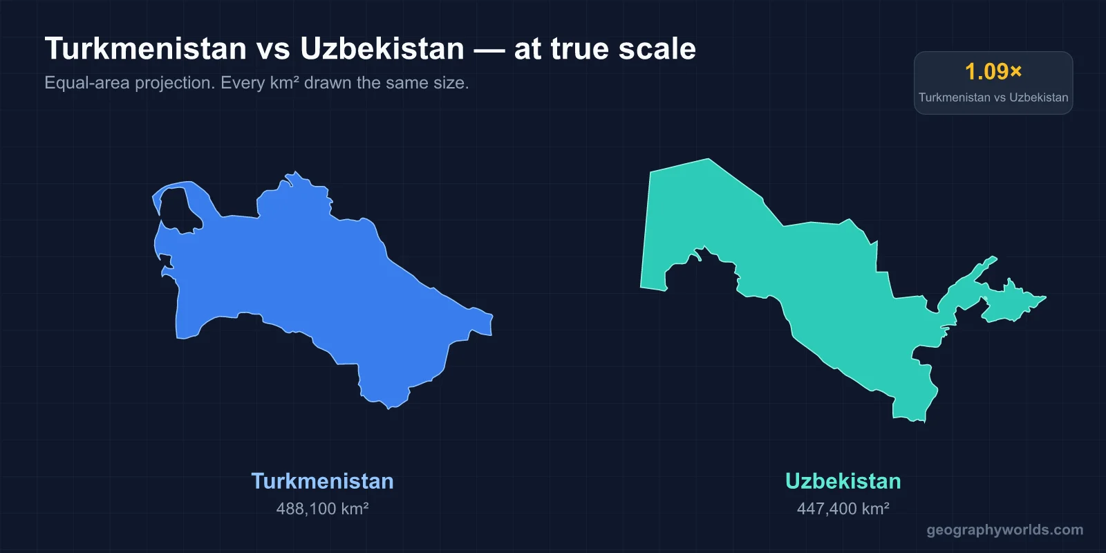
Turkmenistan is slightly bigger, Uzbekistan has far more people, and Turkmenistan is richer per person. Turkmenistan covers about 491,200 km² to Uzbekistan’s 449,000 km², but Uzbekistan’s 2026 census counted about 39.0 million people against the 7.06 million found in Turkmenistan’s 2022 census, more than five times as many. Thanks to natural gas, Turkmenistan’s GDP per person is about $13,300 (IMF, 2025), nearly three times Uzbekistan’s $4,700 (IMF, 2026). Uzbekistan’s capital is Tashkent and its official language is Uzbek; Turkmenistan’s capital is Ashgabat and its official language is Turkmen. Both are Turkic-speaking, mostly Muslim former Soviet republics, and they share a 1,793 km border, which is the best place to start.
The 1,793 km Line the Soviets First Drew in 1925
For most of their history the two countries were not separate places. Before the Russian conquest, the land between the Caspian Sea and the Pamirs was divided among the Emirate of Bukhara and the khanates of Khiva and Kokand, and by the 16th century most Turkmen tribes lived under the nominal control of the two Uzbek khanates, Khiva and Bukhara. Turkmen horsemen served in Uzbek armies, and Turkmen revolts, such as those of the Yomud group in the 19th century, were put down by Uzbek rulers. Russia then absorbed both peoples. After the Battle of Geok Tepe in 1881 the Turkmen lands were annexed along with neighbouring Uzbek territory.
The border itself is a Soviet creation. In the National Territorial Delimitation of 1924 Moscow carved Central Asia into ethnically defined republics, creating the Uzbek SSR on 27 October 1924 and the Turkmen SSR the same year, and the line between them was first fixed in 1925. It was hard to draw. Many Turkmen and Uzbek tribes along the Amu Darya did not fit neatly into either label, and nobody expected the boundary to become international. It did so in 1991. A decade of disputes followed until a treaty in 2000 confirmed the post-independence line, and a border fence went up afterwards.
At 1,793 km it is Turkmenistan’s longest border and Uzbekistan’s second longest, after Kazakhstan. It starts at the Kazakh tripoint in the west and runs through Sarygamysh Lake, where a quarter of the lake’s area lies on the Uzbek side. It then twists around the Khorezm oasis, meets the Amu Darya near Pitnak and Gazojak, follows the river downstream to the 40th parallel, and cuts in straight lines across the Karakum Desert before crossing the Köýtendag Range to the Afghan tripoint. A Soviet-era railway crosses it three times, built when the line was only an internal boundary. Uzbekistan has four other neighbours besides Turkmenistan; our guide to the countries that border Uzbekistan covers them all.
Khiva and Konye-Urgench: Khorezm Split in Two
The clearest sign of the shared past is the old oasis of Khorezm on the lower Amu Darya, which the border now cuts in half. On the Uzbek side stands Khiva, whose walled inner town, Itchan Kala, has been a World Heritage Site since 1990. It keeps more than 50 historic monuments and about 250 old houses, most from the 18th and 19th centuries, including the Juma Mosque, whose prayer hall still stands on 112 columns taken from older buildings.

Just across the line in Turkmenistan lies Konye-Urgench, the site of Gurganj, the old capital of Khwarazm. Its inhabitants left in the early 18th century to found a new settlement, which is why the mosques, mausoleums, caravanserai gates and minaret, dating from the 11th to the 16th centuries, survived largely undisturbed. The ruins were added to the World Heritage List in 2005. The modern town, just south of the border, had about 37,000 people in 2022, while its namesake Urgench, the capital of Uzbekistan’s Xorazm Region, lies on the far side of the line.

One Amu Darya, the Karakum Canal and the Dying Aral Sea
Both countries draw most of their water from the same river. The Amu Darya, the Oxus of classical writers, rises in the Pamirs, carries a mean discharge of about 97 km³ of water a year, and forms part of Afghanistan’s northern frontier with Uzbekistan and Turkmenistan before turning north-west. It no longer reaches the Aral Sea. Much of its flow is diverted to irrigate cotton, the crop the Soviet planners pushed on both republics.
Turkmenistan’s great diversion is the Karakum Canal, dug from 1954 to 1958. It runs 1,375 km across the desert, carries about 13 km³ of Amu Darya water a year and supplies Ashgabat. Uzbekistan irrigates its own fields in the Khorezm oasis and in Karakalpakstan. The downstream result is shared. Since the 1960s the Aral Sea has shrunk to about 10 per cent of its former area, leaving salt- and pesticide-laden soils in Karakalpakstan, the autonomous republic in Uzbekistan’s north-west. Sarygamysh Lake, on the border itself, is now fed by a canal from the Amu Darya and by runoff from irrigated fields that carries pesticides, herbicides and heavy metals.
The landscapes the river crosses differ in scale. More than 80 per cent of Turkmenistan is covered by the Karakum Desert, where some places receive only 12 mm of rain a year, and its highest point, Ayrybaba in the Kugitangtau (Köýtendag) Range on the Uzbek border, reaches 3,137 m. Uzbekistan has its own desert, the Kyzylkum, but also mountains in the east and south-east, rising to Khazret Sultan at 4,643 m. It is also doubly landlocked, one of only two such countries in the world, while Turkmenistan has 1,748 km of shore on the landlocked Caspian Sea.
Tashkent’s 3.1 Million Against Turkmenistan’s 7 Million
The population gap is the starkest difference between the two. Tashkent alone had more than 3.1 million residents in July 2025, making it the largest city in Central Asia; that is close to half of Turkmenistan’s entire population. Uzbeks form more than 89 per cent of Uzbekistan’s people, and Russian and Tajik are significant minority languages, Tajik especially around Samarkand and Bukhara. Turkmenistan is the least populous of the five Central Asian republics and one of the most thinly settled countries in Asia, with about 14 people per km² against Uzbekistan’s 87. Uzbeks are its largest minority, 9.1 per cent of the population according to the 2022 census.
The capitals share one experience: both were largely destroyed by earthquakes. The 1948 Ashgabat earthquake killed more than 110,000 people, about two-thirds of the city’s population. Much of Tashkent was destroyed in the earthquake of 26 April 1966 and rebuilt as a model Soviet city. Since independence Ashgabat, with about 1.03 million people in 2022, has been rebuilt again in costly white marble under the “White City” programme. Both cities are profiled in our guides to Tashkent and Ashgabat.
Language is another near-miss. Uzbek and Turkmen are both Turkic, both were written in Cyrillic from 1940, and both switched to Latin alphabets after independence. Uzbekistan reintroduced Latin in 1992 but still uses Cyrillic alongside it. Turkmenistan adopted its new Latin alphabet in the early 1990s and at first included the pound, dollar, yen and cent signs as letters, before replacing them in 1999.
Galkynysh Gas Against Uzbek Cotton and Power
Turkmenistan’s wealth comes from under the Karakum. It holds the world’s fourth-largest natural gas reserves, and the Galkynysh field near Ýolöten in Mary Province, announced in November 2006 and producing since 2013, is one of the five largest gas fields on Earth. From 1993 to 2019 citizens received electricity, gas and water free up to a monthly quota. The same gas causes one of its best-known sights: the Darvaza crater, a collapsed gas cavern about 260 km north of Ashgabat that has burned for decades.

Gas is also the strongest economic tie between the neighbours. Until 2009 nearly 70 per cent of Turkmen gas exports passed through Russian pipelines. On 14 December 2009 the Central Asia–China pipeline was opened at Saman-Depe by the leaders of China, Turkmenistan, Uzbekistan and Kazakhstan, and it carries Turkmen gas across Uzbekistan towards Xinjiang. More than half of Turkmenistan’s gas exports now go to China that way.
Uzbekistan’s economy is larger and more varied: about $181.5 billion in 2026 against Turkmenistan’s $89 billion in 2025. It remains a major cotton producer and exporter, has oil and gas deposits in the south, and uses its Soviet-era plants to generate more electricity than any other Central Asian state.
Karimov to Mirziyoyev, Niyazov to the Berdimuhamedows
Both countries were run after 1991 by their last Soviet party bosses. Islam Karimov led Uzbekistan until his death on 2 September 2016. Saparmurat Niyazov, styled Türkmenbaşy, was declared President for Life in 1999 and ruled until his death in December 2006. Relations were often strained; between 2002 and 2004 serious tension arose after Niyazov implied that Uzbekistan had a hand in an alleged 2002 attempt on his life.
The successions went different ways. Shavkat Mirziyoyev, president since 14 December 2016 and re-elected in 2021 and again in a snap election in 2023, replaced much of Karimov’s old guard, scheduled the Soviet-style exit visa for abolition in 2019 and opened Uzbekistan to more outside contact. In Turkmenistan Gurbanguly Berdimuhamedow took over in 2007 and was succeeded in 2022 by his son Serdar, in an election observers said was neither free nor fair; the father still shares power. Turkmenistan’s “permanent neutrality”, recognised by the United Nations in 1995, keeps it out of regional blocs, and Reporters Without Borders ranked its press freedom 178th of 180 countries in 2014. The border that the Soviets drew as an internal line now separates a country slowly opening up from one of the most tightly controlled states in the world.