
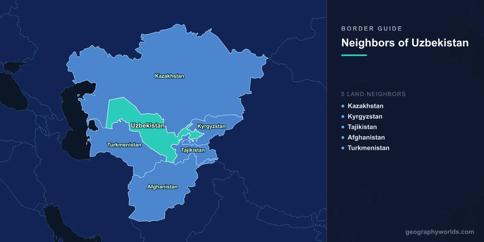
Uzbekistan is bordered by five countries: Kazakhstan along the north and west, Kyrgyzstan and Tajikistan to the east, Afghanistan across a short southern strip, and Turkmenistan to the south-west. Add the five together and you get 6,893 km of land boundary wrapped around a country with no coastline whatsoever.
Plenty of states are landlocked. Uzbekistan belongs to a club of two. Every single one of its neighbours is landlocked as well, so a truck leaving Tashkent for a seaport must clear at least two international frontiers before it smells salt water, whichever compass point it aims for. The only other doubly landlocked country on Earth is Liechtenstein, wedged between Switzerland and Austria. Liechtenstein covers 160 square kilometres and its nearest port is a day away. Uzbekistan covers 447,400 square kilometres, and the nearest workable sea outlet is roughly 2,000 km distant. What is a quirk of trivia for one country is a permanent condition of economic life for the other.
The Five Lines, Measured
The lengths are wildly uneven. One neighbour accounts for a third of the total; another for barely two per cent.
| Neighbour | Length | What mostly defines the line | Share of total |
|---|---|---|---|
| Kazakhstan | 2,330 km | Kyzylkum sands, Ustyurt Plateau, the dry Aral bed | 34% |
| Turkmenistan | 1,793 km | Amu Darya channel, then open desert | 26% |
| Kyrgyzstan | 1,314 km | Fergana Valley floor and the ranges above it | 19% |
| Tajikistan | 1,312 km | Hissar and Turkestan ranges, valley mouths | 19% |
| Afghanistan | 144 km | The Amu Darya, entirely | 2% |
Every one of those lines was drawn between 1924 and 1936, during the Soviet national delimitation of Central Asia, when commissions in Moscow and Tashkent sorted a region of mixed oasis populations into republics that had never existed before. Nobody expected the results to become international borders. In 1991 they did, overnight.
Sand, Steppe, and a Sea That Walked Away
The Kazakh border is the long one — 2,330 km, running from the Fergana approaches near Tashkent all the way west across the Kyzylkum desert and up onto the chalk cliffs of the Ustyurt Plateau. For most of that distance there is nothing to mark it but survey pillars and the occasional patrol track. The two governments signed delimitation agreements in 2001 and 2002 and spent the following fifteen years physically demarcating the result, a job that only wrapped up in the late 2010s.
The busiest point on the whole line sits a few kilometres north of Tashkent at Gisht Kuprik, known on the Kazakh side as Chernyayevka. Uzbekistan's capital was built almost against the boundary, so a crossing that would be a rural formality anywhere else handles a metropolitan commuter load: traders, shuttle workers, families with relatives on both sides.
Further west, the border performs a trick no other boundary in the world can match. It used to run through open water. The Aral Sea was divided between the Kazakh and Uzbek republics, and the line crossed the seabed. Then the Amu Darya and Syr Darya were drained for cotton irrigation from the 1960s onward, and the sea collapsed. Kazakhstan built the Kok-Aral dam in 2005 and clawed back the northern lobe; the southern lobe, the Uzbek half, largely evaporated. The fishing port of Moynaq now sits well over 100 km from any shore, its trawlers rusting on sand. Between the two countries lies the Aralkum, a salt desert that did not exist within living memory, and the border still runs across it exactly where the water used to be. If you want a sense of the scale of the country on the far side of that line, the numbers in how big Kazakhstan actually is are worth a look.
Fergana: A Valley Cut Up Like a Jigsaw Nobody Can Reassemble
East of Tashkent the map stops behaving. The Fergana Valley is a 300 km oval of irrigated farmland ringed by mountains, holding something like a fifth of Central Asia's entire population, and the Soviet delimitation ran the Uzbek, Kyrgyz and Tajik boundaries straight through the middle of it. The result is the densest tangle of enclaves outside Bengal.
Uzbekistan owns several fragments marooned inside Kyrgyzstan. Sokh is the big one — roughly 325 square kilometres and tens of thousands of residents, most of whom are ethnically Tajik, living in an Uzbek enclave inside Kyrgyzstan. Shakhimardan, a mountain resort with a lake, is a second. Kyrgyzstan in turn held the tiny enclave of Barak inside Uzbek territory near Andijan, while Tajikistan's Vorukh, an enclave of some 30,000 people inside Kyrgyzstan, has been the flashpoint for repeated and lethal clashes between border forces.
Water and roads are what make this dangerous. A single canal can serve villages in three jurisdictions; a single road out of an enclave crosses foreign soil. For decades the 1,314 km Uzbek–Kyrgyz line was only about 85 per cent agreed, with the remainder frozen in dispute. That changed in November 2022, when the two governments signed a treaty settling the final sections. The centrepiece was the Kempir-Abad reservoir — Andijan reservoir to Uzbeks — which passed to Uzbek ownership under a joint-management arrangement. The deal was deeply unpopular in Kyrgyzstan and led to arrests of the politicians and activists who campaigned against it, but it was ratified, and Barak's residents were resettled onto Kyrgyz-controlled land in exchange for territory elsewhere. A border that had been an open wound for thirty years is now, on paper, complete.
Mines on the Tajik Line, Then a Sudden Thaw
The Tajik boundary is almost exactly as long as the Kyrgyz one — 1,312 km — and for most of the 2000s it was the most hostile frontier in the region. After armed incursions in 1999 and 2000, Uzbekistan laid minefields along stretches of the mountain border without publishing maps of them. Shepherds and villagers were killed for years afterwards. Crossings closed, direct flights between Tashkent and Dushanbe stopped, and the two governments fell out badly over Tajikistan's Rogun dam project on the Vakhsh, which Uzbekistan regarded as a threat to the water its cotton depended on. In 2012 President Islam Karimov warned publicly that water disputes in the region could end in war.
Karimov died in September 2016. His successor, Shavkat Mirziyoyev, reversed the policy within months. Direct Tashkent–Dushanbe flights resumed in early 2017 after a gap of more than two decades. In March 2018 Mirziyoyev flew to Dushanbe, and a batch of road crossings that had been shut for years reopened; a visa-free regime followed. Demining continued. Uzbekistan dropped its objection to Rogun. It is one of the fastest reversals of a regional posture anywhere in modern Eurasia, and the effects show up in the mundane places — bus timetables, market prices in Khujand and Kokand, families who could suddenly attend each other's weddings.
Where the Amu Darya Does the Work
The Turkmen border is the second-longest at 1,793 km, and geographically the least eventful. It follows the Amu Darya for a stretch above Turkmenabat, then strikes out across the Kyzylkum and Karakum deserts on lines that owe more to Soviet surveying than to any natural feature. Crossings are few and lightly used, in part because Turkmenistan runs one of the most restrictive visa regimes on the planet.
What passes through, though, is significant. The Central Asia–China gas pipeline — three parallel strings — starts on the Turkmen side, enters Uzbekistan near Olot, crosses the country and continues through Kazakhstan into Xinjiang. For all the talk of Central Asian isolation, this is one of the largest gas export systems in the world, and it exists because these landlocked neighbours agreed to let each other's hydrocarbons cross. The same logic drives the wider corridor politics described in the list of China's fourteen land neighbours.
144 Kilometres That Carry More Weight Than the Other 6,749
Uzbekistan's shortest border is its most consequential. The Afghan line runs 144 km along the Amu Darya, and it is crossed in one place: the Friendship Bridge between Termez and Hairatan, a combined road and rail structure the Soviet Union opened in 1982. On 15 February 1989 the last Soviet column drove north across it, with General Boris Gromov walking over the span behind the final vehicle, and the image became the closing frame of that war.
The bridge did not close afterwards. Uzbekistan built the 75 km railway from Hairatan to Mazar-i-Sharif, completed in 2011 and effectively Afghanistan's first functioning modern rail line. Uzbek electricity flows south over the same corridor into the Kabul grid. After the change of government in Kabul in August 2021, Tashkent kept the crossing running and dealt with the new authorities commercially rather than diplomatically, and has since built out a trade and logistics zone at Termez where Afghan traders can operate without visas. Longer term, Uzbekistan's interest in a trans-Afghan railway toward Pakistani ports is the most plausible route by which a doubly landlocked country might finally reach an ocean. The other pressures on that frontier are covered in more depth in the survey of Afghanistan's six neighbours.
What the Shape of the Border Tells You
Read Uzbekistan's outline and you can read its history. The long smooth arcs in the west are desert lines that no one contested because no one lived there. The jagged fingers in the east are irrigation politics, drawn oasis by oasis in the 1920s and inherited as international law in 1991. The 144 km in the south is a river the great powers of the nineteenth century agreed to treat as a limit. And the whole perimeter, all 6,893 km of it, faces inward — toward more landlocked countries, and eventually toward someone else's coast.
The strange consequence is that Uzbekistan's prosperity depends less on what it produces than on how well it gets along with five governments simultaneously, which is exactly the calculation the post-2016 opening was designed to change. If you want to see how well you can place these five neighbours from shape alone, the neighbours game will find your blind spots in Central Asia fast.