
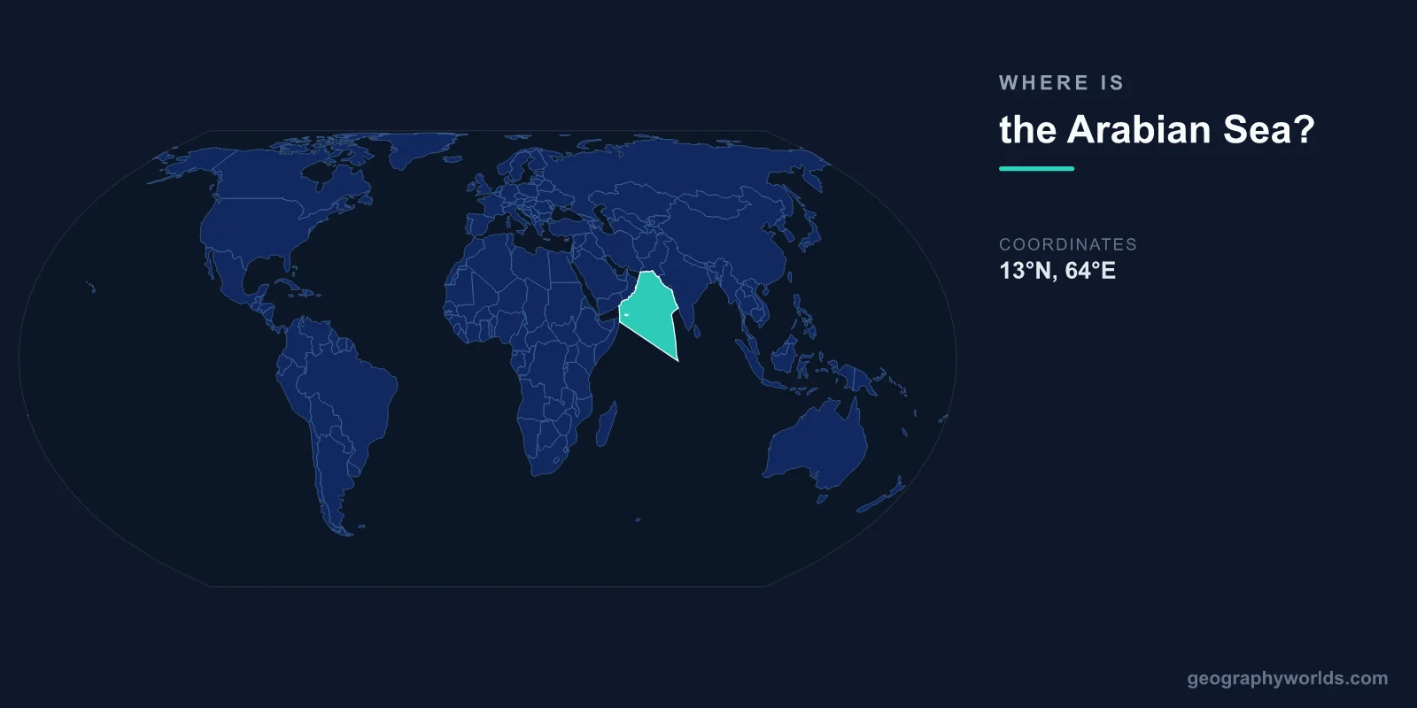
The Arabian Sea is located in the northern Indian Ocean, centered at approximately 15°N latitude and 65°E longitude. It lies between the Indian subcontinent to the east, the Arabian Peninsula to the west, and the Horn of Africa to the southwest. It is one of the busiest and most strategically important shipping lanes in the world.
Introduction
Covering approximately 3,862,000 square kilometers, the Arabian Sea is a major arm of the Indian Ocean. It connects to the Gulf of Aden and the Red Sea to the west through the strait of Bab el-Mandeb, and to the Persian Gulf through the Gulf of Oman and the Strait of Hormuz.

Exact Location & Coordinates
- Center Coordinates: 15°N, 65°E
- Region: Northern Indian Ocean
- Connected To: Red Sea, Persian Gulf, Indian Ocean
On a world map, the Arabian Sea is the large body of water between India and the Middle East. Its eastern boundary is India's western coastline from Mumbai down to Kerala. Its western boundary is the Arabian Peninsula — Yemen, Oman, and the UAE. To the north lies Pakistan's Makran coast, and to the south it merges with the open Indian Ocean.
The simplest way to locate the Arabian Sea is to find India on a map and look at the water to its west. It is bounded roughly between 5°N and 25°N latitude and 45°E and 77°E longitude, forming a roughly triangular shape that narrows toward the north.
Surrounding Countries & Borders
- India: Eastern shore (Mumbai, Goa, Kerala)
- Pakistan: Northern shore (Karachi)
- Oman: Western shore (Muscat)
- Yemen: Southwestern shore (Aden)
- Somalia: Southwestern shore (Mogadishu)
- Maldives: Southern boundary (island chain)
India has the longest coastline on the Arabian Sea, stretching from Gujarat in the northwest to Kerala in the southwest. Major Indian cities on the Arabian Sea include Mumbai, Goa, Mangalore, and Kochi. Pakistan's largest city and main port, Karachi, sits on the northern Arabian Sea coast.
On the western side, Oman's capital Muscat overlooks the Gulf of Oman at the Arabian Sea's northwestern entrance. Yemen and Somalia flank the Gulf of Aden, which connects to the Arabian Sea from the west. The Maldives and Lakshadweep Islands dot the sea's southern and eastern waters.
Geographic Context
- Part Of: Northern Indian Ocean
- Key Straits: Strait of Hormuz, Bab el-Mandeb
- Island Groups: Lakshadweep, Socotra, Maldives (nearby)
The Arabian Sea serves as the gateway between the Indian Ocean and two of the world's most important waterways. The Strait of Hormuz, connecting to the Persian Gulf, handles roughly 20 percent of global oil shipments. The Bab el-Mandeb strait connects to the Red Sea and ultimately the Suez Canal, linking Asia to Europe.
The sea is strongly influenced by the Indian monsoon system. During the southwest monsoon from June to September, powerful winds drive surface currents northeastward, bringing heavy rains to India's western coast. During winter, the northeast monsoon reverses these patterns. Ancient Arab and Indian sailors used these predictable monsoon winds for trade for millennia.
Physical Characteristics
- Area: 3,862,000 km²
- Maximum Depth: 4,652 m (Wheatley Deep)
- Average Depth: 2,734 m
- Major Currents: Somali Current, West Indian Current
The Arabian Sea is considerably deeper than many people expect, reaching 4,652 meters at the Wheatley Deep south of the Murray Ridge. An underwater mountain chain called the Carlsberg Ridge runs through its central portion, part of the global mid-ocean ridge system.
The sea's waters are notably warm, with surface temperatures ranging from 22°C to 28°C throughout the year. During the summer monsoon, upwelling of cold, nutrient-rich water along the coasts of Oman and Somalia creates some of the most productive fisheries in the Indian Ocean, supporting massive plankton blooms visible from space.
Why It Matters
- Shipping: One of world's busiest maritime corridors
- Energy Transit: ~20% of global oil passes through Hormuz
- Fisheries: Major fishing ground for surrounding nations
The Arabian Sea is one of the most critical maritime corridors on Earth. Ships carrying oil from the Persian Gulf, goods from Asia, and cargo transiting the Suez Canal all cross its waters. Port cities like Mumbai, Karachi, and Muscat serve as major hubs for international trade.
Historically, the Arabian Sea was the highway of the ancient Indian Ocean trade network. Arab dhows, Indian merchant vessels, and Chinese treasure ships all sailed its waters, exchanging spices, textiles, gold, and ideas between civilizations. This rich maritime heritage is reflected in the cosmopolitan cultures of its port cities today.
Key Facts
- The Arabian Sea is centered at approximately 15°N, 65°E in the northern Indian Ocean.
- It covers about 3,862,000 km² between India, the Arabian Peninsula, and the Horn of Africa.
- It connects to the Persian Gulf via the Strait of Hormuz and to the Red Sea via Bab el-Mandeb.
- Its maximum depth reaches 4,652 m at the Wheatley Deep.
- About 20% of global oil shipments pass through its connected waterways.
Fun Facts
- The Arabian Sea was one of the first oceans to be regularly navigated, with trade routes dating back over 5,000 years.
- Socotra, an island in the Arabian Sea off Yemen, has flora so unique it's called the "Galapagos of the Indian Ocean."
- The summer monsoon creates upwelling so intense that plankton blooms are visible from space.
- Cyclones in the Arabian Sea have become significantly more intense in recent decades due to warming waters.
Final Thoughts
The Arabian Sea is a vast expanse of the northern Indian Ocean, situated between India and the Arabian Peninsula at approximately 15°N, 65°E. As the gateway to both the Persian Gulf and the Red Sea, it carries a significant share of global maritime trade. From ancient monsoon-driven commerce to modern oil tanker routes, the Arabian Sea remains one of the most strategically and economically important bodies of water on the world map.
Test Your Knowledge!
Think you know where things are on the map? Test your skills!
Play Geography Games →