
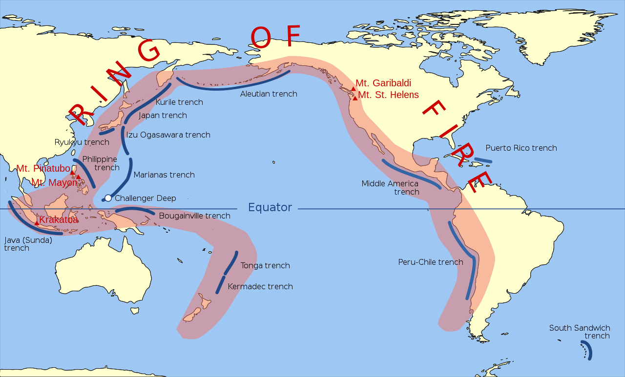
The Ring of Fire (also called the Circum-Pacific Belt) is a roughly 40,000-kilometer horseshoe-shaped zone of intense volcanic and seismic activity that encircles the Pacific Ocean. It stretches from New Zealand, along the eastern edge of Asia, north across the Aleutian Islands, and south along the western coast of the Americas from Alaska to Chile.
Introduction
The Ring of Fire contains approximately 450 active volcanoes — about 75 percent of the world's total — and is the site of roughly 90 percent of the world's earthquakes. It exists because the Pacific Plate and several smaller plates are being subducted beneath the surrounding continental plates, generating the volcanic and seismic activity that defines the ring.

Exact Location & Coordinates
- Shape: Horseshoe/ring around the Pacific Ocean (~40,000 km)
- Active Volcanoes: ~450 (75% of world's total)
- Earthquakes: ~90% of all earthquakes occur along the Ring
- Countries: ~15 countries on the Ring of Fire
The Ring of Fire is not visible as a single feature on a map but becomes clear when earthquake epicenters or volcano locations are plotted. A dense cluster of dots forms a nearly continuous ring around the Pacific. The ring runs from New Zealand through Tonga, Indonesia, the Philippines, Japan, Kamchatka, the Aleutian Islands, and then down the west coast of the Americas from Alaska through the Cascades, Mexico, Central America, and the Andes to Chile.
The ring is not perfectly circular — it has a gap in Antarctica and across the southern Pacific. The highest concentration of activity is along the western Pacific, particularly in Indonesia (127 active volcanoes — more than any other country), the Philippines, Japan, and Kamchatka.
Surrounding Countries & Borders
- East Asia: Japan, Philippines, Indonesia, Papua New Guinea
- Oceania: New Zealand, Tonga, Samoa, Fiji
- North America: USA (Alaska, Pacific Northwest), Canada
- South America: Chile, Peru, Ecuador, Colombia
- Russia: Kamchatka Peninsula
Japan sits at one of the Ring of Fire's most active sections, where the Pacific, Philippine Sea, and Eurasian plates converge. This has made Japan one of the most earthquake-prone countries on Earth, with the 2011 Tohoku earthquake (magnitude 9.1) and tsunami being among the deadliest natural disasters in modern history.
Chile occupies the longest stretch of any single country on the Ring of Fire. The Nazca Plate subducting beneath the South American Plate generates frequent large earthquakes, including the 1960 Valdivia earthquake (magnitude 9.5), the most powerful earthquake ever recorded. Chile has more than 2,000 volcanoes, of which about 90 are active.
Geographic Context
- Subduction Zones: Where oceanic plates dive beneath continental plates
- Volcanic Arcs: Chains of volcanoes parallel to subduction trenches
- Deep Ocean Trenches: Mariana Trench (10,935 m), Tonga Trench (10,823 m)
- Transform Faults: San Andreas Fault (California) is part of the Ring
The Ring of Fire coincides with the boundaries of the Pacific Plate and several smaller plates (Nazca, Cocos, Philippine Sea, Juan de Fuca). At most of these boundaries, dense oceanic plate is being subducted beneath lighter continental plate. As the oceanic plate descends into the mantle, it releases water that lowers the melting point of the overlying mantle, generating magma that rises to create volcanic arcs.
The deepest ocean trenches on Earth — the Mariana Trench, Tonga Trench, Philippine Trench, and Kuril-Kamchatka Trench — are all along the Ring of Fire, marking the points where oceanic plates plunge into the mantle. These trenches represent the deepest points on Earth's surface.
Physical Characteristics
- Length: ~40,000 km
- Major Volcanic Eruptions: Numerous historical eruptions (Krakatoa, Pinatubo, St. Helens)
- Major Earthquakes: 9 of the 10 largest recorded earthquakes occurred on the Ring
- Tsunami Risk: Most tsunamis originate from Ring of Fire earthquakes
Nine of the ten largest earthquakes ever recorded occurred along the Ring of Fire: the 1960 Chile earthquake (M9.5), the 1964 Alaska earthquake (M9.2), the 2004 Indian Ocean earthquake (M9.1, which was on the Ring's western extension), and the 2011 Japan earthquake (M9.1) among them. These massive earthquakes generate tsunamis that can cross entire ocean basins.
Major volcanic eruptions along the Ring of Fire have shaped human history. Krakatoa's 1883 eruption killed over 36,000 people and affected global climate. Mount Pinatubo's 1991 eruption cooled global temperatures by 0.5°C for a year. Mount St. Helens' 1980 eruption in Washington State was the deadliest and most destructive volcanic event in US history.
Why It Matters
- Hazard: ~500 million people live in zones of direct volcanic or seismic risk along the Ring
- Tsunami Warning: Pacific Tsunami Warning Center monitors the entire Ring
- Resources: Subduction creates mineral deposits and geothermal energy
- Prediction: Understanding the Ring is key to earthquake and eruption forecasting
Roughly 500 million people live in areas of direct volcanic or seismic risk along the Ring of Fire. Major cities including Tokyo, Manila, Jakarta, Lima, Santiago, Seattle, and Vancouver are all within the Ring. Earthquake-resistant building codes, tsunami warning systems, and volcanic monitoring networks are critical for protecting these populations.
The Ring of Fire also provides benefits. Subduction-related processes concentrate valuable mineral deposits (copper, gold, silver) in volcanic arc regions. Countries like Chile, Peru, Indonesia, and the Philippines are major mining producers partly because of Ring of Fire geology. Geothermal energy from volcanic heat powers electricity generation in Iceland, New Zealand, the Philippines, Indonesia, and elsewhere.
Key Facts
- The Ring of Fire encircles the Pacific Ocean for ~40,000 km.
- It contains ~450 active volcanoes (75% of the world's total) and ~90% of all earthquakes.
- 9 of the 10 largest recorded earthquakes occurred along the Ring of Fire.
- The Ring exists because oceanic plates are being subducted beneath continental plates around the Pacific.
- ~500 million people live in zones of direct volcanic or seismic risk along the Ring.
Fun Facts
- The Ring of Fire is responsible for the deepest point on Earth (Mariana Trench, 10,935 m) and the most powerful earthquake (Chile, 1960, M9.5).
- Indonesia has 127 active volcanoes — more than any other country on the Ring.
- Mount Pinatubo's 1991 eruption along the Ring cooled global temperatures by 0.5°C for a year.
- The Pacific Tsunami Warning Center was established in 1949 after a devastating tsunami from a Ring of Fire earthquake hit Hawaii.
Final Thoughts
The Ring of Fire encircles the Pacific Ocean for roughly 40,000 kilometers, a zone where the collision and subduction of tectonic plates generates 75 percent of the world's volcanoes and 90 percent of its earthquakes. It is simultaneously the most geologically dangerous and geologically productive region on Earth — the source of devastating earthquakes and tsunamis, but also of mineral wealth and geothermal energy. Understanding the Ring of Fire is essential for protecting the 500 million people who live along its active margins.
Test Your Knowledge!
Think you know where things are on the map? Test your skills!
Play Geography Games →