
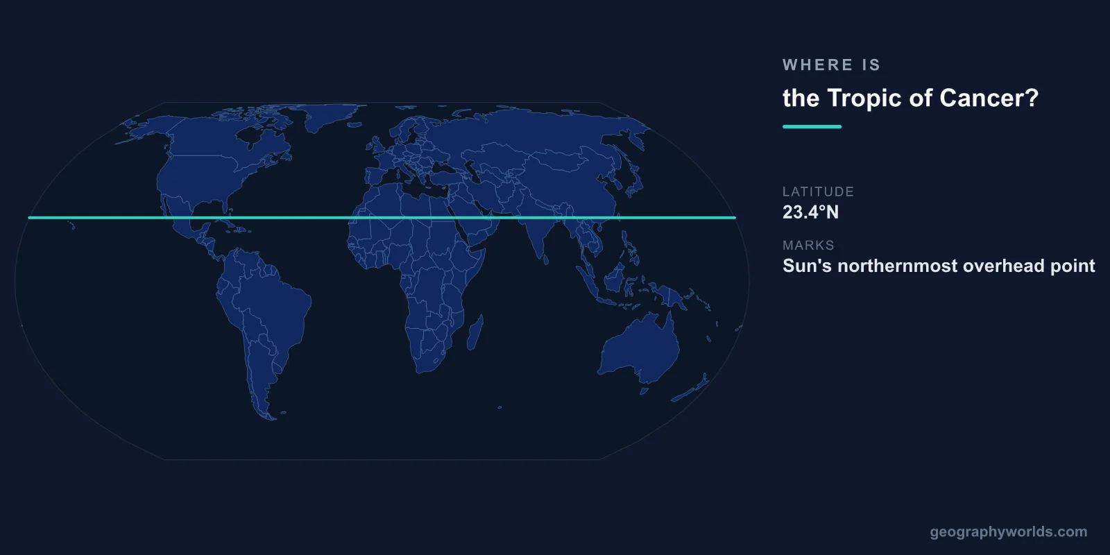
The Tropic of Cancer is located at approximately 23.436°N latitude (roughly 23°26'N), circling the Earth through northern Africa, the Middle East, South Asia, East Asia, the Pacific, Mexico, and the Caribbean. It marks the most northerly latitude at which the Sun can appear directly overhead, which occurs on the June solstice (approximately June 21).
Introduction
The Tropic of Cancer, together with the Tropic of Capricorn (23.436°S), defines the tropics — the zone between these two latitudes where the Sun can be directly overhead at least once per year. The word "cancer" refers to the constellation Cancer, where the Sun appeared during the June solstice when the line was named by ancient Greek astronomers (due to precession, the Sun is now in the constellation Taurus at the solstice).

Exact Location & Coordinates
- Latitude: 23.436°N (23°26'N)
- Circumference: ~36,788 km at this latitude
- Countries Crossed: 16 countries and territories
- Movement: Shifts ~0.47 arcseconds per year (currently moving south)
The Tropic of Cancer crosses 16 countries: Mexico (Baja California Sur, Sinaloa, Durango, Zacatecas, San Luis Potosi, Nuevo Leon, Tamaulipas), Bahamas, Western Sahara, Mauritania, Mali, Algeria, Libya, Niger, Chad, Egypt, Saudi Arabia, UAE, Oman, India, Bangladesh, Myanmar, China, and Taiwan.
The tropic's latitude is not fixed — it shifts slightly each year due to the slow change in Earth's axial tilt. Currently at about 23.436°N, it is slowly moving southward at roughly 14.4 meters per year. Over a 41,000-year cycle, the tilt varies between 22.1° and 24.5°, shifting the tropics accordingly.
Surrounding Countries & Borders
- North America: Mexico, Bahamas
- Africa: Western Sahara, Mauritania, Mali, Algeria, Libya, Niger, Chad, Egypt
- Middle East: Saudi Arabia, UAE, Oman
- Asia: India, Bangladesh, Myanmar, China, Taiwan
In India, the Tropic of Cancer passes through eight states: Gujarat, Rajasthan, Madhya Pradesh, Chhattisgarh, Jharkhand, West Bengal, Tripura, and Mizoram. This line roughly marks the transition from India's tropical south to its subtropical north, affecting climate, agriculture, and vegetation patterns across the subcontinent.
In China, the Tropic of Cancer passes through Yunnan, Guangxi, Guangdong, and Taiwan provinces. The line's passage through southern China marks the northernmost extent of the tropical climate zone that supports rice paddies, tropical fruits, and dense vegetation characteristic of southern China.
Geographic Context
- June Solstice: Sun is directly overhead at the Tropic of Cancer on ~June 21
- Tropical Zone: Area between Cancer (23.5°N) and Capricorn (23.5°S)
- Subtropical Deserts: Many of the world's great deserts lie near or on the Tropic of Cancer
- Hadley Cell: Descending dry air at ~23.5°N creates desert conditions
The Tropic of Cancer's latitude coincides with the descending limb of the Hadley cell — the atmospheric circulation pattern where rising equatorial air sinks back toward the surface around 23-30°N. This sinking dry air creates high-pressure zones that suppress rainfall, which is why many of the world's great deserts lie near the Tropic of Cancer: the Sahara, Arabian Desert, Thar Desert, and Sonoran Desert.
The alignment of desert belts with the Tropic of Cancer is one of the most visible patterns in world geography. Looking at a world map, the band of arid land stretching from the Sahara through Arabia to the Thar Desert in India closely follows the 23.5°N line, demonstrating the powerful link between atmospheric circulation and surface climate.
Physical Characteristics
- Circumference at this Latitude: ~36,788 km (shorter than the equator's 40,075 km)
- Solar Angle: Sun at 90° elevation on June solstice; at 43° on December solstice
- Day Length: ~13.5 hours on June solstice; ~10.5 hours on December solstice
- Axial Tilt: Earth's 23.436° tilt determines the tropic's position
The position of the Tropic of Cancer is a direct consequence of Earth's axial tilt of 23.436°. If the Earth had no tilt, the Sun would always be directly over the equator, and the tropics (and seasons) would not exist. The greater the tilt, the farther from the equator the tropics extend. Mars, with a similar tilt (25.19°), has analogous tropical zones.
On the June solstice, an observer at the Tropic of Cancer experiences the longest day of the year (~13.5 hours of daylight) and sees the Sun reach the zenith (directly overhead) at solar noon. This is the only day of the year when the Sun is at exactly 90° elevation at this latitude. Six months later, on the December solstice, the same location has only about 10.5 hours of daylight.
Why It Matters
- Climate: Defines the northern boundary of the tropics
- Agriculture: Marks the transition from tropical to subtropical crops
- Deserts: Many of the world's major deserts lie near this latitude
- Culture: Has cultural significance in many civilizations (solstice celebrations)
The Tropic of Cancer has practical significance for agriculture and climate. Areas south of the line (within the tropics) can grow tropical crops like rice, sugarcane, and tropical fruits year-round. Areas north of the line are subtropical or temperate and require different agricultural practices. The line roughly marks the boundary between tropical and subtropical biomes.
Historically, the tropics were defined by the Sun's apparent movement, and many ancient civilizations built monuments aligned with solstice positions. The Tropic of Cancer was a key concept in ancient Greek astronomy and geography, used by Eratosthenes to estimate the circumference of the Earth around 240 BCE — one of the great scientific achievements of antiquity.
Key Facts
- The Tropic of Cancer is at ~23.436°N latitude, marking the Sun's northernmost overhead position.
- It crosses 16 countries across North America, Africa, the Middle East, and Asia.
- Many of the world's great deserts (Sahara, Arabian, Thar) lie near this latitude.
- The Sun is directly overhead at the Tropic of Cancer on the June solstice (~June 21).
- The tropic's position slowly shifts due to changes in Earth's axial tilt over a 41,000-year cycle.
Fun Facts
- The Tropic of Cancer is named after a constellation where the Sun no longer appears during the solstice — precession has shifted it to Taurus.
- The tropic moves southward at about 14.4 meters per year due to slow changes in Earth's axial tilt.
- Eratosthenes used the difference in sun angle between the tropic and Alexandria to calculate Earth's circumference around 240 BCE.
- If Earth had no axial tilt, there would be no tropics, no seasons, and a radically different climate.
Final Thoughts
The Tropic of Cancer at approximately 23.436°N marks the northern boundary of the tropics and the most northerly point where the Sun can appear directly overhead. Its coincidence with the world's great desert belt, its role in defining Earth's climate zones, and its significance in the history of astronomy and geography make it one of the most important imaginary lines on the planet. Though invisible, its effects on climate, agriculture, and human settlement are profoundly real.
Test Your Knowledge!
Think you know where things are on the map? Test your skills!
Play Geography Games →