

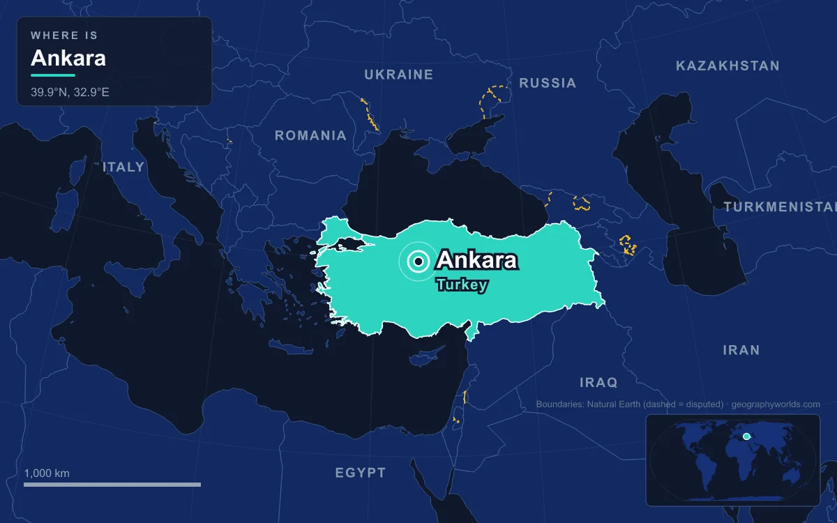
Ankara is the capital of Turkey, a city of about 5.3 million people (urban population at the end of 2025, out of 5.9 million in Ankara Province) that stands at roughly 938 metres on the steppe of Central Anatolia. Its core is a rocky hill rising about 150 metres over the left bank of the Ankara River, a tributary of the Sakarya, and the ruined castle on that hill explains why a small Anatolian market town was able to replace Istanbul as the seat of government in 1923. Everything else in Ankara, from Roman temples to Atatürk's mausoleum, was built outward from that outcrop.
The Lava Outcrop Above the Ankara River
Start at the top of the citadel and the logic of the place is visible at once. The foundations of Ankara Castle were laid by the Galatians on a prominent lava outcrop, and the earliest fortification on the site is attributed to the Phrygians in the 8th century BC. The inner circuit of walls encloses an area of roughly 350 by 150 metres, with closely spaced towers; an outer line with towers about 40 metres apart wraps around it. Both were built largely from reused masonry, and both postdate the Persian capture of the city, most likely in 622 AD, when the old Roman town contracted into a medieval fortress.
The hill commanded a small river that once ran through the centre of the Roman town and formed the northern edge of the old city for more than a thousand years. That stream has since been covered and diverted, and the Çubuk Brook now crosses the city centre before joining the Ankara River in the western suburbs. Around this core the land opens into the broad basin between two major rivers, the Kızılırmak to the east and the Sakarya to the west, which forms the provincial border with Eskişehir. The province touches Bolu and Çankırı to the north, Konya to the south and Kırıkkale to the east.
South of the citadel rises a second height, Çankaya, which stood well outside the Roman city and was still a hillside of orchards and gardens in 1920. Today it is the district with the highest elevation in the city, home to the Grand National Assembly and nearly all of the foreign embassies in Turkey. The two hills, one ancient and one republican, frame the valley in which modern Ankara sprawls.

Ancyra, Where the Roads of Roman Anatolia Crossed
The site has been inhabited since the Bronze Age Hattians, who were absorbed by the Hittites around 2000 to 1700 BC. The town grew substantially under the Phrygians from about 1000 BC, partly through migration from their capital Gordion after an earthquake. Phrygian tradition named King Midas as its founder. Greek settlers from Pontus developed it as a trading centre around 300 BC and gave it the name Ánkyra, meaning anchor, from which the modern name descends.
In 278 BC a Celtic people, the Galatians, occupied central Anatolia, and Ancyra became the headquarters of their Tectosages tribe. The Celtic language lasted a remarkably long time: at the end of the 4th century St. Jerome observed that the speech around Ankara resembled that spoken near Trier. In 25 BC Augustus made the city the capital of the Roman province of Galatia, and the Temple of Augustus and Rome was built between 25 and 20 BC. On its walls is the Monumentum Ancyranum, the most complete surviving copy of the Res Gestae Divi Augusti, the emperor's own account of his achievements, inscribed in Latin inside the porch with a Greek translation outside. Only the side walls and the ornamented door frame still stand.
Geography, again, explains the city's size. Ancyra sat at the junction of the north-south and east-west roads of northern Anatolia, on the imperial highway toward Rome's eastern frontier. In good times an estimated 200,000 people lived there, a figure the city would not reach again until the 20th century. The same roads carried invaders: Goths and Arabs raided in the 3rd century, the Sasanian Persians took the city around 622, and the armies of Caliph al-Mu'tasim razed it in 838. Under Byzantium it served as capital of the Opsician and then the Bucellarian themes, military provinces that depended on exactly this position astride the roads.
Angora Wool, the Seljuks and the Battle of 1402
After the Battle of Manzikert in 1071, Turkish settlers reached the area by 1073, and the city passed between the Danishmends and the Seljuk Sultanate of Rum for most of the 12th century. The Seljuk prince Muhiddin Mesud Şah completed the Alâeddin Mosque, the oldest mosque in Ankara, in 1178; its carved walnut pulpit still records the date. In Europe the city became known as Angora, and in Ottoman Turkish as Engürü.
The dry plateau suited grazing animals, and the long-haired Angora goat, source of mohair, together with the Angora rabbit and the Angora cat, carried the old name around the world. The city exported mohair and Angora wool for centuries, and in the 19th century also shipped goat skins, gum, wax, honey, berries and madder root. Ankara remains known for its pears, its honey and its Muscat grapes.
Orhan, the second Ottoman ruler, captured the city in 1356. In 1402 Timur defeated Sultan Bayezid I at the Battle of Ankara on the plain nearby and took the town, although it was back in Ottoman hands by 1403. Hacı Bayram Mosque, built beside the Temple of Augustus in the early 15th century and later restored by Mimar Sinan, stands right against the walls of the Roman temple, a neat summary of how each era reused the hill. For most of the Ottoman period Ankara was a provincial centre, capital of the Angora Vilayet from 1867 to 1922, and it was linked to Istanbul by railway before the First World War.
Why the 1920 Resistance Chose an Inland Town
After the Ottoman defeat in 1918, Allied forces occupied Constantinople and much of Anatolia. The nationalist movement led by Mustafa Kemal Atatürk needed a headquarters out of reach of the occupying fleets but still connected to the rest of the country, and Ankara fitted both needs: it lay deep in the interior, far from any coast, and it sat on the railway. On 23 April 1920 the Grand National Assembly of Turkey opened there, and the town directed the War of Independence.
After victory and the Treaty of Lausanne of 1923, which superseded the Treaty of Sèvres, Ankara officially replaced Constantinople as the capital on 13 October 1923. The Republic of Turkey was proclaimed on 29 October. At that point the new capital was, in a contemporary phrase, a small town of no importance: it had about 35,000 residents in 1924. From 1930 the city was officially known in Western languages as Ankara, and by the late 1930s the English name Angora had fallen out of use.
Jansen's Plan, Ulus and Kızılay
The government designed the capital as a planned city for 500,000 future inhabitants. In 1927 it invited three European planners to compete for a master plan: Léon Jaussely of France and Joseph Brix and Hermann Jansen of Germany. Jansen won in 1929. His plan left the old city around the citadel in place rather than engulfing it, built the new town alongside it, split the city into functional zones with 18 residential sections, and insisted on green belts and gardens. Criticism and political interference meant it was never fully carried out, and in 1938 Jansen asked for his signature to be removed from it.
The result is a city with two centres. Ulus, the old section below the castle, keeps the Roman, Byzantine and Ottoman buildings and narrow, winding streets. Yenişehir, the new section now centred on Kızılay Square, has the wide boulevards, ministries, embassies, hotels and high-rises. The water supply was engineered from the start: the Çubuk-1 Dam, built between 1930 and 1936 about 12 kilometres north of the centre, was the first concrete dam in Turkey. Atatürk attended its opening on 3 November 1936.

Atatürk died on 10 November 1938. His body was kept at the Ankara Ethnography Museum while a design competition was held, and in 1939 the governing party chose Rasattepe, a hill in the city, as the site. The winning design by Emin Onat and Orhan Arda was begun in 1944, and Anıtkabir was completed in 1953, when his remains were moved there on 10 November. Like the castle, it was placed on a height, a third hill added to the city's skyline.
From the 1950s growth outran the plan. Migrants from the countryside, many of them from the shrinking provinces of Çorum and Yozgat, built informal houses called gecekondu on the slopes around the city. Many have since been replaced by tower-block estates such as Elvankent, Eryaman and Güzelkent. Ankara overtook İzmir to become Turkey's second-largest city after Istanbul.
A Semi-Arid Capital on the Central Anatolian Steppe
The plateau setting shapes daily life. Ankara has a cold semi-arid climate, with snowy winters and hot, dry summers. Monthly mean temperatures range from 0.9°C in January to 24.3°C in July, and annual precipitation averages only about 414 millimetres, falling mostly in spring and autumn. The surrounding land is mostly steppe vegetation, with forest only on the southern edge, yet the city counts about 72 square metres of green space per inhabitant.
The crossroads position that made Ancyra important still defines the modern city, which sits at the centre of Turkey's road and rail networks. Ankara Central Station is a hub for high-speed YHT trains: the line to Eskişehir opened on 13 March 2009, the line to Konya on 23 August 2011, and the Ankara to Istanbul service on 25 July 2014. Esenboğa Airport lies to the north-east, and the city's metro, the Ankaray light rail and the Başkentray suburban line together carry about 400,000 commuters a day.
Government is a major employer, but Ankara is also a centre of Turkey's defence and aerospace industry, with Turkish Aerospace Industries, ASELSAN and ROKETSAN based there, and the OSTIM Industrial Zone is the largest industrial park in the country. Ankara Province also has Turkey's highest share of university graduates, at about 29 percent. For the wider setting of the plateau the city grew from, see our guide to the Anatolian Plateau; for the Hittite world, one of whose cult centres, Ankuwaš, has been tentatively identified with Ankara, visit Hattusa, and for the old capital Ankara replaced, read about Istanbul, Turkey's largest city.
Quick Facts About Ankara
- Country: Turkey
- Continent: Asia (Middle East)
- Country population: approximately 87.9 million
- Capital city status: Ankara is the capital of Turkey, the seat of national government, and the location of foreign embassies, parliament, and the head of state's official residence.
Frequently Asked Questions
What is the capital of Turkey?
The capital of Turkey is Ankara. Ankara is the seat of national government, hosts most foreign embassies and consulates, and is typically where the head of state and parliament are located.
What continent is Ankara in?
Ankara, the capital of Turkey, is located in Asia, in the Middle East region. As Turkey's capital, Ankara serves as the country's primary connection to the broader Asian political, economic, and cultural sphere.
Why is Ankara the capital of Turkey?
Ankara was chosen as the capital of Turkey for reasons that typically combine geography, history, and politics. Capital city selections often reflect a desire for centrality (being accessible from across the country), historical importance (being a longstanding seat of government or culture), or neutrality (being acceptable to multiple regions or ethnic groups within the country). The specific reasons for Ankara's designation are detailed in the city's history above.
What is Ankara known for?
As the capital of Turkey, Ankara is best known for housing the country's central government institutions — parliament, presidential or royal residences, supreme court, and key ministries. It is also typically a major cultural and economic center within Turkey, hosting national museums, embassies, and signature monuments. The introduction and history sections above provide detailed coverage of the city's specific notable institutions and landmarks.
Related Pages
- Turkey Country Guide — full geography, climate, economy, and culture overview
- Flag of Turkey — meaning, history, and design of Turkey's national flag