

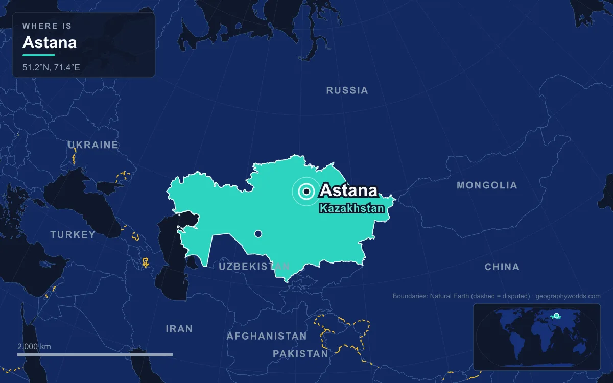
Astana is the capital of Kazakhstan, a planned city of more than 1.5 million people (1,528,703 in January 2025) built on the Ishim River in the flat, semi-arid steppe of the country’s north. It replaced Almaty as capital on 10 December 1997, and it is defined by the setting it was placed in: a river crossing on open grassland, 347 metres above sea level, where January averages −14.5 °C and a skyline of glass towers now rises from what was a provincial Soviet town.
A Crossing on the Ishim, 347 Metres Up
Everything about Astana starts with the Ishim, which Kazakhs call the Esil. The river is 2,450 kilometres long, rising in the uplands of central Kazakhstan and flowing north into Russia, where it meanders through marshland before joining the Irtysh. Its upper course passes straight through the capital. Around the city the land barely rises or falls. Astana sits at 51° 10′ north and 71° 26′ east, in a spacious steppe landscape, in the transition zone between the farmed north of Kazakhstan and the thinly settled centre of the country.
On land this flat, a reliable river is the one feature that decides where people settle. Water and grazing made the site useful long before there was a city. Today the Ishim divides Astana into two halves. North of the river, on the Right Bank, lies the older town. South of it, on the Left Bank, stands the new capital of ministries, embassies and apartment towers.

The river you see in the city centre is managed rather than natural. Since 1998 the Ishim in Astana has been dammed downstream of the centre to keep its level higher than it would otherwise be, and its bed has been deepened so floods pass through faster. Water is even pumped in from the Irtysh, via the Irtysh–Karaganda Canal and a pipeline, to keep the flow up. Without the dam, according to local accounts, residents could at times have walked across it. Now there is a public beach near the city park, pedalo hire, and, since 2008, organised river navigation within the city.
Bozok, Akmoly and the Road to Tselinograd
People used this crossing centuries before the modern city. On the territory of today’s Astana stood Bozok, a fortified settlement of the 12th to 14th centuries on the steppe branch of the Silk Road. Its name is usually linked to the Turkic word boz, which can mean untouched earth, virgin soil or feather grass. The modern city is now expanding over the ground Bozok once occupied.
The present settlement dates from 18 June 1830, when Fyodor Shubin set up a Russian outpost on the Ishim called Akmoly. It gained town status in 1832 as Akmolinsk. In 1838, during the uprising led by Kenesary Khan, the fortress was burned, then rebuilt. The site’s value lay in its position: by the 1860s, picket roads connected it to Kargaly in the east, Aktau Fort in the south and, through Atbasar, to Kokshetau in the west. Growth was slow. For its first three decades the town held little more than 2,000 people, and by 1893 Akmolinsk, by then an uyezd town, counted 6,428 residents, three churches and five schools.
The steppe itself changed the city’s course in the 1950s. From 1954 the northern Kazakh oblasts became the heart of Nikita Khrushchev’s Virgin Lands Campaign, which ploughed up grassland to create a second grain belt for the Soviet Union. Akmolinsk became the administrative seat of the new Tselinny Krai, and on 20 March 1961 it was renamed Tselinograd, “City of the Virgin Lands”. The 1960s brought the first high-rise housing districts, a Virgin Lands Palace, a Palace of Youth, a new airport and sports venues. Tselinograd had 281,000 people by 1989, and only 17.7% of them were Kazakh.
Why the Steppe City Replaced Almaty in 1997
Almaty, in the far south-east beneath the Tian Shan mountains, had served as capital since 1929, first of Soviet Kazakhstan and then of the independent republic. After independence the city on the Ishim, renamed Akmola in 1991, was chosen instead. The Supreme Council adopted the decree on transferring the capital on 6 July 1994. The move took effect on 10 December 1997, the city was renamed Astana, Kazakh for “capital city”, in May 1998, and it was presented to the world as the new capital on 10 June 1998.
The official case rested largely on geography. The government cited room for urban growth, a favourable central position, proximity to the region’s economic centres, demographic capacity, good transport links and a relatively favourable climate. The nearest large cities are Karaganda, about 200 kilometres away, and Omsk in Russia, about 450 kilometres away. Almaty lies almost 1,000 kilometres to the south-east. President Nursultan Nazarbayev also said the presence of the river was part of the reason the site was picked. A capital on the northern steppe moved the seat of government from the south-eastern corner of a country of about 2.7 million square kilometres, the ninth-largest in the world, towards its middle.
The name has not stayed fixed. In March 2019 the city became Nur-Sultan in honour of Nazarbayev, shortly after his resignation as president. In September 2022 President Kassym-Jomart Tokayev signed a constitutional amendment restoring Astana. As of 2022 it held the Guinness World Record for the capital with the most name changes in modern times.
The population followed the ministries. The city more than doubled in its first decade as capital, passed one million in 2017 and more than tripled its 2002 figure by 2025. The ethnic balance swung just as sharply. Kazakhs were 17% of the city at independence and about 83% by 2026, with migrants arriving from across Kazakhstan and from neighbouring Uzbekistan and Kyrgyzstan.
Kisho Kurokawa’s Left Bank Plan
In April 1998 the government invited international architects and planners to compete for the design of the new capital. On 6 October 1998 the first prize went to the Japanese architect Kisho Kurokawa. His proposal kept and redeveloped the existing city north of the river and built a new city to the south and east of the Ishim. He called the idea a “symbiosis” of history and the future.
The result is a city laid out in bands. North of the east–west railway line lie industrial districts and poorer housing. Between the railway and the river is the old centre. South of the Ishim, on the Left Bank, stands the government quarter, including the Akorda presidential residence, the House of Government and the Supreme Court. It also holds a diplomatic quarter and the most expensive apartment complexes. Astana is now split into four districts: Almaty and Saryarka, both created in 1998; Yesil, the Left Bank district, created in 2008; and Baikonur, created in 2018. The city’s chief planner, Vladimir Laptev, has said he wanted a Berlin in Eurasian style rather than a purely administrative capital like Canberra.
Money followed. The Astana – New City special economic zone opened in 2001, and the Astana International Financial Centre in July 2018. State corporations including Samruk-Kazyna, Kazakhstan Temir Zholy, KazMunayGas and Kazatomprom are headquartered here. By the mid-2010s the city produced about 8.5% of Kazakhstan’s gross domestic product.
January at −14.5 °C: Astana and the Steppe Winter
The open steppe that made the site easy to build on also makes it one of the harshest capitals to live in. Astana is the second-coldest national capital in the world after Ulaanbaatar in Mongolia. Before 1997 that position belonged to Ottawa. Under the 1991–2020 normals January averages −14.5 °C and July 20.6 °C, with an annual mean of just 3.9 °C. From mid-December to early March, temperatures of −30 to −35 °C are common, and the record low, set in 1893, is −51.6 °C. Summers are short and warm, and can briefly reach 35 °C.
With no hills to break the air, wind is the other constant. Kazakhs know the city for its strong winds, which are felt most on the wide, open avenues of the Left Bank. The Ishim usually freezes from the second week of November until early April, so the river that gives the city its summer beach spends almost five months of the year under ice. Several of the capital’s signature buildings were designed as shelters from exactly this climate.
Baiterek, Khan Shatyr and Nur Alem on the Skyline
The capital’s best-known buildings borrow directly from steppe imagery. Baiterek, commissioned in 1996 and designed by the Kazakh architect Akmurza Rustembekov, stands on Nurjol Boulevard as a symbol of the move from Almaty. Its name means “tall poplar tree”, and it embodies a folktale in which the magic bird Samruk laid her egg in the fork between two branches of the tree of life. The white steel structure is 105 metres tall and supports a gold-mirrored sphere 22 metres across, with an observation deck 97 metres above the ground. Nazarbayev chose the design over rivals partly on cost: roughly $5 million against about $60 million for a 200-metre arch proposed by Zurab Tsereteli.

At the far end of the boulevard from the Akorda rises Khan Shatyr, the “Grand Marquee”, designed by Norman Foster’s practice, unveiled as a project in December 2006 and opened on 5 July 2010. It is a transparent tent 150 metres high including its spire, covering an elliptical base of 200 by 195 metres. Its ETFE roof is meant to hold the interior between 15 and 30 °C while outside temperatures swing between −35 and 35 °C across the year. Under it are shops, a boating river and an indoor beach resort. Foster’s office also designed the 62-metre Palace of Peace and Reconciliation, a pyramid completed in 2006 to host the Congress of Leaders of World and Traditional Religions.

Expo 2017, themed “Future Energy”, opened on 10 June 2017 as the first world’s fair held in Central Asia and drew more than four million visitors. Its central pavilion, Nur Alem, is described as the largest spherical building in the world. The Astana Grand Mosque, completed in 2022, is the largest mosque in Central Asia. Almost none of this would stand without the decision to put the capital on this stretch of river, and to understand the grassland around it, our guide to what a steppe is is a good start. How Astana’s winters compare with other frozen cities is covered in our list of the coldest cities in the world, and the wider country is laid out in the Kazakhstan country guide.
Quick Facts About Astana
- Country: Kazakhstan
- Continent: Asia (Central Asia)
- Country population: approximately 21.1 million
- Capital city status: Astana is the capital of Kazakhstan, the seat of national government, and the location of foreign embassies, parliament, and the head of state's official residence.
Frequently Asked Questions
What is the capital of Kazakhstan?
The capital of Kazakhstan is Astana. Astana is the seat of national government, hosts most foreign embassies and consulates, and is typically where the head of state and parliament are located.
What continent is Astana in?
Astana, the capital of Kazakhstan, is located in Asia, in the Central Asia region. As Kazakhstan's capital, Astana serves as the country's primary connection to the broader Asian political, economic, and cultural sphere.
Why is Astana the capital of Kazakhstan?
Astana was chosen as the capital of Kazakhstan for reasons that typically combine geography, history, and politics. Capital city selections often reflect a desire for centrality (being accessible from across the country), historical importance (being a longstanding seat of government or culture), or neutrality (being acceptable to multiple regions or ethnic groups within the country). The specific reasons for Astana's designation are detailed in the city's history above.
What is Astana known for?
As the capital of Kazakhstan, Astana is best known for housing the country's central government institutions — parliament, presidential or royal residences, supreme court, and key ministries. It is also typically a major cultural and economic center within Kazakhstan, hosting national museums, embassies, and signature monuments. The introduction and history sections above provide detailed coverage of the city's specific notable institutions and landmarks.
Related Pages
- Kazakhstan Country Guide — full geography, climate, economy, and culture overview
- Flag of Kazakhstan — meaning, history, and design of Kazakhstan's national flag