
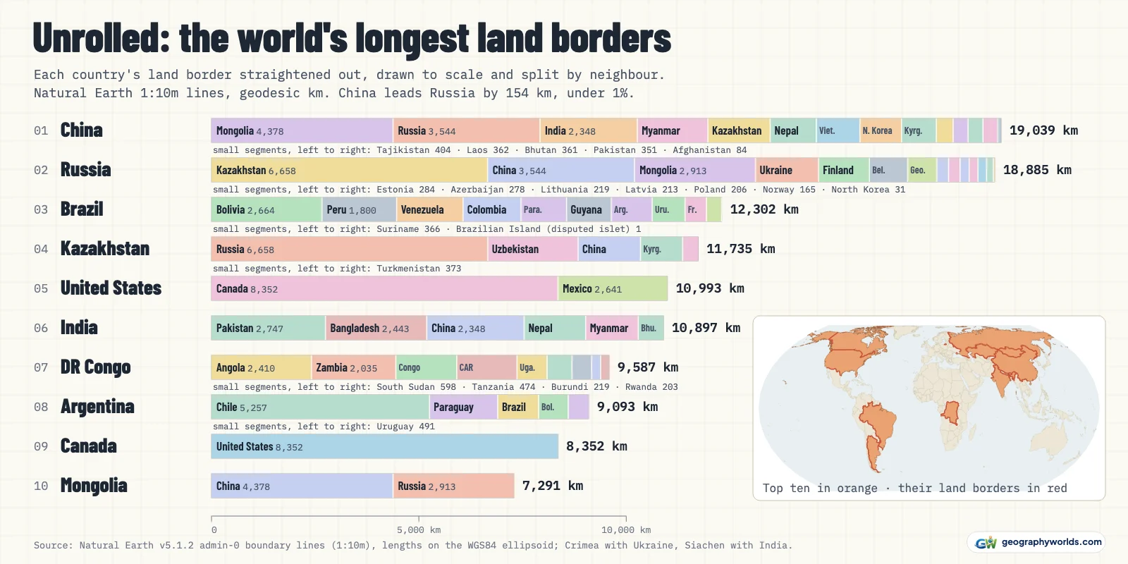
China has the longest land border of any country: 19,039 km on Natural Earth's detailed 1:10m world map. Russia is a whisker behind at 18,885 km, then come Brazil (12,302 km), Kazakhstan (11,735 km), the United States (10,993 km), India (10,897 km), the Democratic Republic of the Congo (9,587 km), Argentina (9,093 km), Canada (8,352 km) and Mongolia (7,291 km). Coastlines are a separate measurement, covered further down. The longest border between two countries is the one between Canada and the United States.
Rather than copy published figures, we measured: all 515 lines in Natural Earth's 1:10m land-boundary file, each measured on the WGS84 ellipsoid and added up for every country and every pair of neighbours, then checked against the Factbook's final edition and the agencies that survey individual borders. Where the sources disagree, the answers below say why.
Which ten countries top the list, and how far apart are they?
The same ten countries top the Factbook's list, in a slightly different order: China, Russia, Brazil, India, Kazakhstan, United States, Argentina, DR Congo, Canada, Mongolia. The biggest mover is India, fourth in the Factbook and sixth here, for reasons explained in the Kashmir answer.
| # | Country | Land border, 1:10m map (km) | Neighbours | Longest single border | CIA Factbook (km) | CIA rank | Ours vs CIA |
|---|---|---|---|---|---|---|---|
| 1 | China | 19,039 | 14 | Mongolia (4,378 km, 23%) | 22,457 | 1 | -15% |
| 2 | Russia | 18,885 | 14 | Kazakhstan (6,658 km, 35%) | 22,407 | 2 | -16% |
| 3 | Brazil | 12,302 | 10 | Bolivia (2,664 km, 22%) | 16,145 | 3 | -24% |
| 4 | Kazakhstan | 11,735 | 5 | Russia (6,658 km, 57%) | 13,364 | 5 | -12% |
| 5 | United States | 10,993 | 2 | Canada (8,352 km, 76%) | 12,002 | 6 | -8% |
| 6 | India | 10,897 | 6 | Pakistan (2,747 km, 25%) | 13,888 | 4 | -22% |
| 7 | DR Congo | 9,587 | 9 | Angola (2,410 km, 25%) | 11,027 | 8 | -13% |
| 8 | Argentina | 9,093 | 5 | Chile (5,257 km, 58%) | 11,968 | 7 | -24% |
| 9 | Canada | 8,352 | 1 | United States (8,352 km, 100%) | 8,892 | 9 | -6% |
| 10 | Mongolia | 7,291 | 2 | China (4,378 km, 60%) | 8,082 | 10 | -10% |
Two places in the ranking are near ties. The United States is only 96 km ahead of India, and Mongolia keeps tenth place by just 49 km over Mali, whose 7,242 km of border is shared with 7 neighbours.
Is China really ahead of Russia?
Yes, but only just. In our main count China leads by 154 km, or 0.8% of its total. The Factbook puts China at 22,457 km and Russia at 22,407 km, a gap of 50 km.
Where the margin comes from depends on two disputed places. The first is Crimea. Natural Earth draws Crimea as Russian and marks the 147 km line across the Perekop isthmus as a disputed Russia–Ukraine border. Our main count follows the internationally recognised border instead, as affirmed by UN General Assembly resolution 68/262 in March 2014, so that line is internal to Ukraine. The second is the Siachen Glacier, which Natural Earth draws as a separate unit. India has administered all of Siachen since 1984, so we give its edges to India, which adds 102 km to the China–India line.
| Treatment of the two disputed areas | China (km) | Russia (km) | Longer border |
|---|---|---|---|
| Crimea with Ukraine, Siachen with India (our main count) | 19,039 | 18,885 | China by 154 km |
| Crimea with Russia, Siachen with India | 19,039 | 19,032 | China by 7 km |
| Crimea with Ukraine, Siachen left out | 18,937 | 18,885 | China by 52 km |
| Both as Natural Earth draws them (Crimea with Russia, Siachen separate) | 18,937 | 19,032 | Russia by 94 km |
Count Crimea as Russian and the gap closes to 7 km: China 19,039 km, Russia 19,032 km. Leave Siachen out of every country instead and China drops to 18,937 km, still ahead. Only when both choices go Russia's way, which is exactly how Natural Earth's file is drawn, does Russia lead, by 94 km. So China is first, but the two are practically level.
Why are these numbers shorter than the ones in atlases?
Every total in our table is shorter than the Factbook's, by 6% for Canada up to 24% for Argentina. A border is a wiggly line, and the length you measure depends on how much of the wiggle your map keeps. This is the coastline paradox, and it applies to borders as much as to shores.
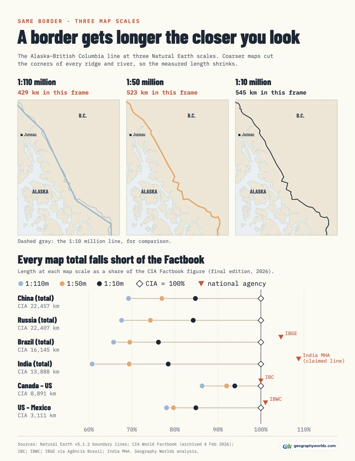
Natural Earth publishes the same boundaries at three scales, which lets us watch it happen. Measured on the coarse 1:110m map, all the lines in Natural Earth's land-boundary file add up to 198,111 km. At 1:50m the total is 214,305 km, and at 1:10m it is 235,077 km. China's border grows from 15,552 km to 17,290 km to 19,039 km as the map sharpens, and Russia's from 15,156 km to 16,657 km to 18,885 km.
Argentina's shortfall is the largest in the top ten. Canada's is the smallest: 5,061 km of its boundary with the United States is on land, where it is, in the International Boundary Commission's words, a series of straight lines between boundary monuments, which even a coarse map can follow. Rivers are harder, and the US–Mexico border shows it. The International Boundary and Water Commission gives it as 1,954 miles, about 3,145 km, of which 1,255 miles follow the centre of the Rio Grande; on the 1:10m map it is 2,641 km.
What is the longest border between two countries?
Canada and the United States share the longest border in the world: 8,352 km on the 1:10m map. The International Boundary Commission, set up under a 1908 treaty to re-establish and map the line, gives the surveyed length as 8,891 km: 6,416 km from the Atlantic to the Pacific and 2,475 km between Alaska and Canada. Of the total, 5,061 km is on land and 3,830 km runs through rivers and lakes, including the Great Lakes. Our map line is 6% shorter overall, with almost exactly the same shortfall on the Alaska section (2,316 km against 2,475 km) as on the southern one (6,036 km against 6,416 km).

The Factbook gives the same 8,891 km. That one border is 76% of the United States' entire land frontier and, on the 1:10m map, all of Canada's. The Factbook also lists 1.3 km between Canada and Denmark (Greenland), a sliver our map does not include. Our guide to the US–Canada border travels along it section by section.
Second is Kazakhstan–Russia at 6,658 km (7,644 km in the Factbook), which is 57% of Kazakhstan's land border and 35% of Russia's. Third is Argentina–Chile at 5,257 km, or 6,691 km in the Factbook, which is 58% of Argentina's total. China–Mongolia (4,378 km) and China–Russia (3,544 km) come next.
How are disputed borders like Kashmir counted?
We use the lines where control actually changes hands, as Natural Earth draws them, except where an internationally recognised border exists. In Kashmir there is no agreed border, so the India–Pakistan total of 2,747 km includes 796 km of lines Natural Earth classes as the Line of Control, plus the Siachen edge. China's lines with India are marked as disputed for 1,647 km of their length, in Ladakh, in the middle Himalaya and in the east.
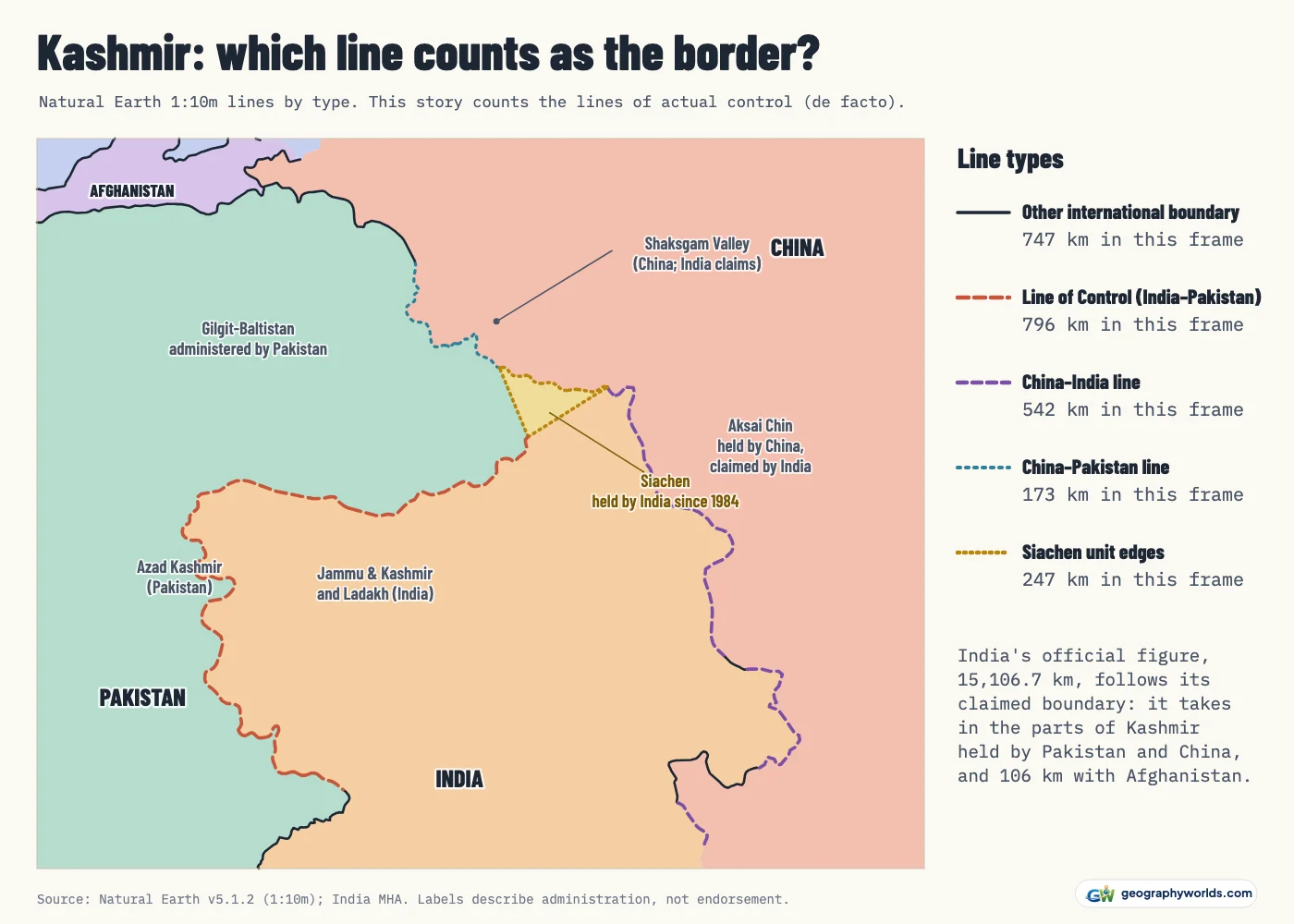
India's government measures something different. The Ministry of Home Affairs' Department of Border Management gives India 15,106.7 km of land border, including 3,488 km with China, 3,323 km with Pakistan and 106 km with Afghanistan. Those figures follow India's claimed boundary, which takes in the parts of Kashmir held by Pakistan and by China; that is why India counts a border with Afghanistan at all. On the lines it actually holds, India has 10,897 km, or 10,731 km if Siachen is left out. The Factbook's 13,888 km sits between the two. The Kashmir border dispute explains how the region came to be divided.
Lines that are not borders between countries are left out: China's boundaries with Hong Kong and Macau, the outlines of the Korean demilitarised zone and the Cyprus buffer zone, and the leased areas at Baikonur (286 km, inside Kazakhstan) and Guantanamo Bay.
Which countries have the most neighbours?
China and Russia have 14 land neighbours each, more than any other country. China's, in order of border length, are Mongolia, Russia, India, Myanmar, Kazakhstan, Nepal, Vietnam, North Korea, Kyrgyzstan, Tajikistan, Laos, Bhutan, Pakistan, Afghanistan. Russia's are Kazakhstan, China, Mongolia, Ukraine, Finland, Belarus, Georgia, Estonia, Azerbaijan, Lithuania, Latvia, Poland, Norway, North Korea; its borders with Lithuania and Poland belong to the Kaliningrad exclave. Brazil and France come next with 10 each (France through French Guiana). Brazil's statistics agency IBGE also counts ten neighbours and puts the land border at 16,900 km, Agência Brasil reported in 2021. Our map measures 27% less.
At the other extreme, two of the top ten have hardly any neighbours. Canada has a single neighbour on our map and Mongolia has 2: 60% of Mongolia's 7,291 km is with China and the remaining 2,913 km is with Russia. Kazakhstan, fourth overall, has the longest border of any landlocked country.
How do coastlines compare with land borders?
They are different measurements, and the coastline paradox hits coasts much harder. Canada shows the contrast best. Its 1:10m outline, minus the land border, gives 136,858 km of coastline, about 16 times its land border. The Factbook's coastline entry gives 202,080 km and credits the 36,563 islands of the Canadian Arctic Archipelago for making it the world's longest.
For the United States the sources spread even wider. The Factbook gives 19,924 km. The 1:10m outline gives 67,756 km. NOAA's shoreline table gives 95,439 miles, about 153,594 km, because it follows every sound, bay and tidal creek and adds the Great Lakes and the territories. None is wrong; they answer different questions. Our ranking of countries with the longest coastlines deals with the shore side of the map.
Where do these numbers come from, and can I use them?
The lines are Natural Earth version 5.1.2 (public domain). Each is measured with Vincenty's formula on the WGS84 ellipsoid (a simple sphere would change the world total by only 0.05%) and credited to the countries on either side. The 1:50m and 1:110m files carry no country names, so each of their lines takes the pair of the nearest 1:10m line. The Factbook figures come from its final edition: the CIA retired the World Factbook on 4 February 2026, so we read the Internet Archive's copy of its land-boundaries and coastline pages from that day.
You can download the data as a CSV, with every country's measured total at all three map scales, its Factbook figure and the length shared with each neighbour. Anyone who wants to plot a comparison of their own can load the file into Parity, which makes charts from spreadsheet data. Sources:
- Natural Earth v5.1.2: admin-0 boundary lines (land), 1:10m, 1:50m and 1:110m, and admin-0 countries, 1:10m: Public domain (Natural Earth terms of use). De facto boundaries; read from the GeoJSON release in the natural-earth-vector repository, tag v5.1.2.
- CIA World Factbook, field listing 'Land boundaries' and 'Coastline' (final edition, archived 4 February 2026): Public domain US government work. The CIA retired the Factbook on 4 February 2026; figures read from the Internet Archive copy of the final pages.
- International Boundary Commission (Canada–United States): The Boundary, and Boundary facts: Official length of the Canada–US boundary (8,891 km) and its land and water parts.
- International Boundary and Water Commission (US–Mexico): About us: Official length of the US–Mexico boundary (1,954 miles).
- Ministry of Home Affairs, India, Department of Border Management: Introduction: India's official land border lengths (15,106.7 km in total).
- Agência Brasil (6 July 2021), reporting IBGE's survey of border municipalities: Brazil's land border: 16,900 km, with ten neighbours (IBGE).
- NOAA Office for Coastal Management: Shoreline Mileage of the United States: US tidal shoreline, 95,439 statute miles, including the Great Lakes and territories.
For the story behind the line where the two leaders meet, our guide to the Russia–China border follows it from the Treaty of Nerchinsk in 1689 to the present day.