
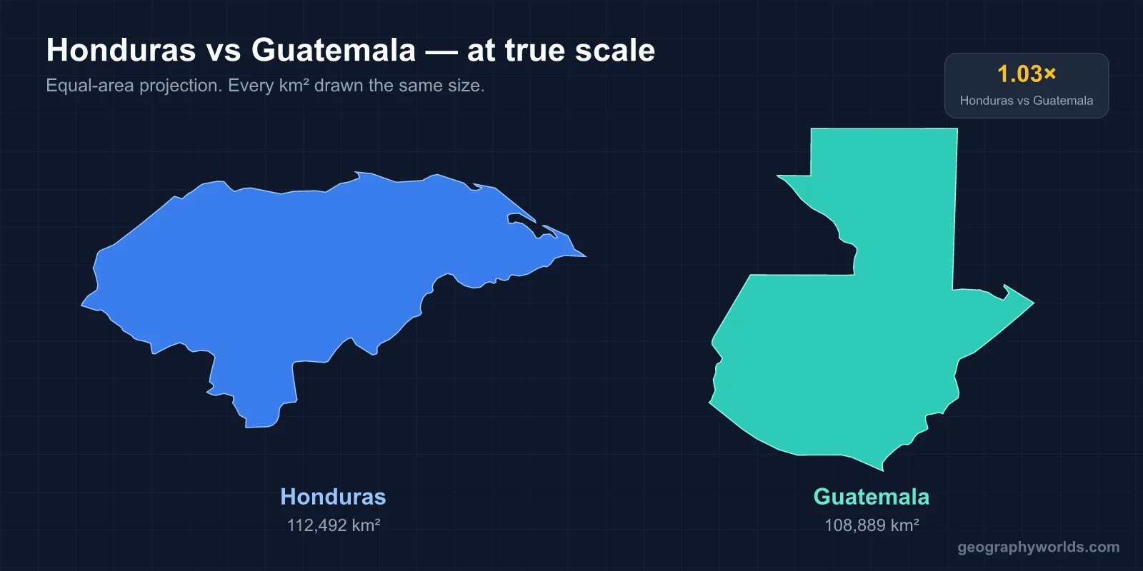
Honduras is slightly bigger, at 112,492 km² against Guatemala’s 108,889 km², but Guatemala has far more people: about 18.6 million in 2025 compared with roughly 10.2 million in Honduras in 2026. Guatemala is also richer per person, with nominal GDP per capita of about $6,700 in 2025 against about $3,600 for Honduras, according to IMF estimates. Guatemala’s capital is Guatemala City and Honduras’s is Tegucigalpa. Spanish is the official language of both, but in Guatemala some 21 or 22 Mayan languages (counts differ) are spoken alongside Xinca and Garifuna, while Honduras is overwhelmingly Spanish-speaking, with Garifuna and Miskito communities on its Caribbean side. Guatemala also has the higher mountains, topped by Volcán Tajumulco at about 4,200 m, the highest peak in Central America.
The two share a border about 256 km long, running from the mouth of the Motagua River on the Gulf of Honduras to the tripoint with El Salvador on the Montecristo massif. Its line was settled by arbitration in 1933. The questions below take the main points of comparison one at a time.
Which Is Bigger, Honduras or Guatemala?
Honduras, by about 3,600 km², a margin of just over 3%. On a map the two look almost the same size, and their shapes are similar too: both reach both oceans. Honduras has a long northern coast on the Caribbean, through the Gulf of Honduras, and a short Pacific outlet on the Gulf of Fonseca, which it shares with El Salvador and Nicaragua. Guatemala has a Pacific coastline in the south and a short Caribbean frontage on the Gulf of Honduras, where the port of Puerto Barrios and the town of Livingston lie, between the Sarstún River border with Belize and the Motagua River border with Honduras.
Honduras also owns an island group that Guatemala lacks. The Bay Islands, 15 to 60 km off the north coast, consist of eight islands and 53 small cays with a combined area of 250 km²; Roatán is the largest, and the department capital is Coxen Hole. They have been administered by Honduras since 1872 and lie on the Mesoamerican Barrier Reef System.
The land inside those borders is laid out differently. In Honduras, a large and little-developed lowland jungle, La Mosquitia, fills the north-east, and the Río Plátano Biosphere Reserve protects its rainforest, while the heavily populated Sula Valley lies in the north-west. The climate runs from tropical in the lowlands to temperate in the mountains, and the Pacific side is drier than the Caribbean. Guatemala’s north is the rainforest lowland of Petén; its rivers include the Polochic and the Río Dulce, which drain into Lake Izabal, the Motagua, and the Usumacinta, which forms the boundary between Petén and the Mexican state of Chiapas.
Which Has More People, 18.6 Million or 10.2 Million?
Guatemala, by a wide margin. Its roughly 18.6 million people make it the most populous country in Central America, and with less land than Honduras that means about 170 people per km², compared with about 90 in Honduras. Both countries have seen large emigration, especially to the United States: a 2012 US State Department estimate put the number of Hondurans living there at between 800,000 and a million, nearly 15% of the Honduran population at the time.
The make-up of the two populations differs just as much. At the 2018 census, 43.6% of Guatemalans identified as Indigenous, one of the highest shares in the Americas after Peru and Bolivia, and 41.7% of the national population were Maya, the largest groups being the K’iche’ (11.0%), Q’eqchi’ (8.3%), Kaqchikel (7.8%) and Mam (5.2%). About 56% were Ladino, of mixed Indigenous and European descent. Honduran society is predominantly Mestizo, with Indigenous, Black and White minorities; the Garifuna, Miskito and Bay Island Creoles are among its non-Ladino groups, and the Ch’orti’ Maya survive in the west near the Guatemalan border.
Which Is Richer Per Head: Guatemalans or Hondurans?
Guatemala, on every headline measure. The IMF’s 2025 estimates give Guatemala a nominal GDP per capita of about $6,682 against $3,640 for Honduras, and at purchasing-power parity about $15,386 against $7,960. Guatemala’s economy is also the larger in total, because of its bigger population.
Neither country is well off by regional standards, and poverty rates are high in both. Honduras’s National Institute of Statistics reported that 73% of the population lived in poverty in 2022 and 53% in extreme poverty. In Guatemala, 56% lived in poverty and 16.2% in extreme poverty as of 2024. Remittances from emigrants have become a pillar of the Guatemalan economy, rising from 11% to 19% of GDP between 2004 and 2024. On the UN Human Development Index for 2023 the two are close: Guatemala scores 0.662 (137th) and Honduras 0.645 (139th). Income is very unequal in both, with a Gini coefficient of 45.2 for Guatemala (2023) and 52.1 for Honduras (2018).
History explains part of the gap. Honduras’s export economy grew around bananas on the north coast; the writer O. Henry coined the term “banana republic” in his 1904 novel Cabbages and Kings, inspired by the six months he spent there. In 1998 Hurricane Mitch destroyed about 70% of Honduran crops and an estimated 70–80% of its transport infrastructure, including nearly all bridges and secondary roads. Guatemala built its export economy on coffee from the 19th century, but endured a civil war from 1960 to 1996; a UN-backed truth commission estimated that Maya people made up 83% of the victims of documented violations.
Which Is Higher: Tajumulco or Cerro Las Minas?
Guatemala, clearly. Its highlands lie along the Motagua Fault, part of the boundary between the Caribbean and North American plates, and the country has 37 volcanoes, four of them active: Pacaya, Santiaguito, Fuego and Tacaná. Volcán Tajumulco, a stratovolcano in the department of San Marcos, is the highest point in Central America; sources give its height as 4,203 m or 4,220 m.
Honduras is mostly mountainous too, with narrow coastal plains, but its peaks are lower. The highest is Cerro Las Minas in the Cordillera de Celaque, in the Lempira department in the west. Local maps give it 2,849 m, while satellite data suggest about 2,870 m, which still leaves it more than 1,300 m below Tajumulco. Celaque National Park was created around it in 1987. Honduras’s cloud forests reach almost 3,000 m.
Guatemala City or Tegucigalpa: Which Capital Is Higher and Larger?
Guatemala City lies higher, at about 1,500 m in the Valle de la Ermita, against about 990 m for Tegucigalpa, which spreads over hills from 975 m to 1,463 m. The answer on size depends on the boundary used. For 2023, projections put Tegucigalpa’s population at about 1.33 million and Guatemala City proper at about 1.22 million, but Guatemala City’s metropolitan area, at about 3.2 million, is the largest in Central America.
Both capitals were latecomers. Guatemala City was founded after the colonial capital, now Antigua Guatemala, was wrecked by the Santa Marta earthquake of 1773. Tegucigalpa became the Honduran capital only on 30 October 1880, when President Marco Aurelio Soto moved the government from Comayagua. Honduras also has a second urban pole in the north: San Pedro Sula, in the Sula Valley, had about 1.45 million people in its metropolitan area in 2023 and is the largest city in Central America that is not a capital.
Tikal or Copán: Where Did the Maya Build More?
Guatemala has the greater number of Maya cities, and the largest concentration of Classic-period sites lies in Petén. Tikal, in the Petén rainforest, was the capital of one of the most powerful Maya kingdoms and reached its peak between about AD 200 and 900. Its national park became a UNESCO World Heritage Site in 1979.
Honduras has one outstanding site of its own. Copán, in a fertile valley of the Copán River at about 600 m in the far west, a short distance from the Guatemalan border, was the capital of a major Classic kingdom from the 5th to the 9th century and was abandoned in the early 10th century. It sat on the south-eastern periphery of Mesoamerica, on the frontier between Maya and non-Maya lands.

Honduras was also a meeting ground of cultures: the Sula Valley was a core area for Mesoamerica and La Mosquitia for the Isthmo-Colombian region. In 2012 LiDAR scanning revealed previously unknown dense settlements in La Mosquitia.
Atitlán or Yojoa: Which Has the Deeper Lake?
Guatemala again. Lake Atitlán in the Sololá department of the western highlands is about 18 km long, 340 m deep at its deepest and 154 m deep on average, which makes it the deepest lake in Central America. Its name comes from Nahuatl and means “between the waters”.

Honduras’s largest lake, Lake Yojoa, is broad but shallow: 79 km² of water with an average depth of 15 m, lying at about 700 m in a depression formed by volcanoes, between Santa Bárbara and Cerro Azul Meambar national parks. It sits on the highway linking Tegucigalpa and San Pedro Sula, and travellers often stop there for fried fish.
Which Left the Central American Federation First?
They did so together, then separately. Both were part of the colonial Kingdom of Guatemala, which stretched from Chiapas to Costa Rica, and both declared independence from Spain on 15 September 1821 and from the First Mexican Empire on 1 July 1823. They then joined the Federal Republic of Central America. Honduras left it on 5 November 1838 and Guatemala on 17 April 1839; Guatemala proclaimed itself a republic on 21 March 1847.
For more on each side of the border, see the guides to Copán, Tikal and Guatemala City.