
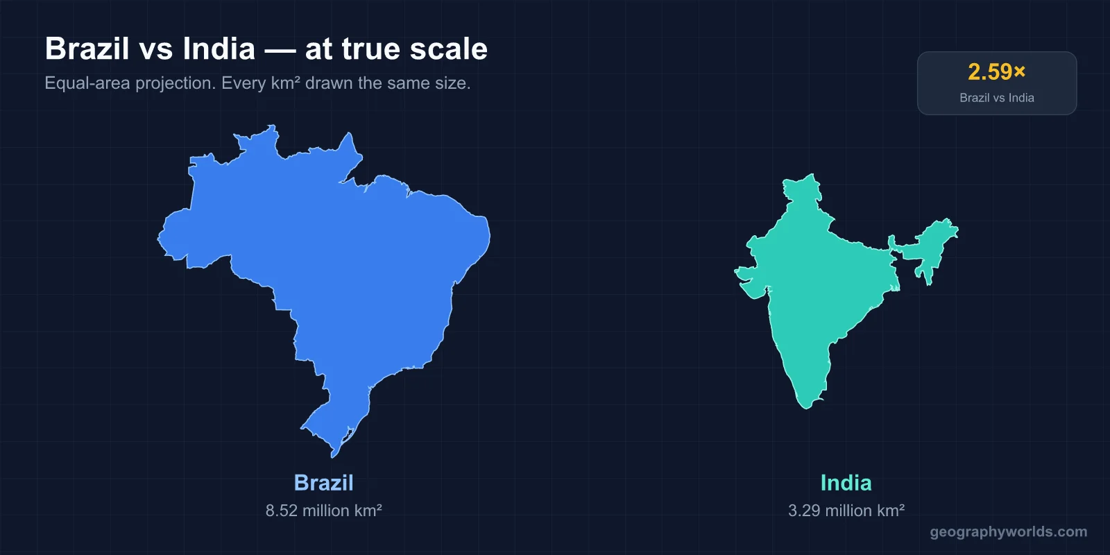
Brazil is the bigger country, India has far more people, and Brazil is the richer of the two per person. Brazil covers about 8.5 million km², roughly 2.6 times India’s 3,287,263 km², but India’s population is estimated at about 1.48 billion in 2026, roughly seven times Brazil’s estimated 214 million (its 2022 census counted 203 million). IMF estimates for 2026 put Brazil’s GDP per person at about US$12,313 and India’s at about US$2,813. India’s capital is New Delhi and its official languages at national level are Hindi and English, with 22 languages recognised in its constitution; Brazil’s capital is Brasília and its official language is Portuguese. For a traveller the contrast is just as sharp: one country is a crowded subcontinent walled off by the Himalaya and ruled by the monsoon, the other a half-continent of rainforest, wetland and Atlantic beaches where the seasons run the other way round.
From Kangchenjunga to the Pantanal: The Landscapes You Cross
India’s scenery is organised by one mountain wall. The Himalaya runs along the north, and the highest peak on territory India administers is Kangchenjunga, the world’s third-highest mountain at 8,586 m, on the border between Sikkim and Nepal. On a clear morning it fills the northern skyline of the hill town of Darjeeling. Below the mountains lies the Indo-Gangetic Plain, the densely farmed lowland drained by the Ganges, which rises in Uttarakhand and runs 2,525 km through India and Bangladesh to the Bay of Bengal. West of the ancient Aravalli hills, which begin at the Delhi Ridge, spreads the Thar Desert of Rajasthan. The south is the old Deccan Plateau, edged on the west by the Western Ghats, which catch the monsoon and leave much of the interior in rain shadow. Its climate map runs from ice cap in the western Himalaya and cold desert in eastern Ladakh to hot desert in Rajasthan and tropical rainforest in the Sundarbans.

Brazil has no mountains on the Himalayan scale. Its highest point, Pico da Neblina in northwestern Amazonas state, just inside the border with Venezuela near the edge of the Guiana Highlands, reaches about 2,995 m, about a third of Kangchenjunga’s height. What Brazil has instead is water and forest on a scale India cannot match. About 60% of the Amazon rainforest lies inside Brazil, and the Amazon River carries more water than any other river on earth. In the southwest, the Pantanal, mostly in Mato Grosso do Sul, is the world’s largest tropical wetland, covering some 140,000 to 160,000 km² that flood and drain each year. Between these lie the Cerrado of the central plateau, and along the coast the remnants of the Atlantic Forest, which together with the Amazon make Brazil the most biodiverse country on the planet.
On the southern border the landscape turns to basalt cliffs. The Iguaçu River, a tributary of the Paraná, drops over the Iguazu Falls, shared with Argentina, in a staircase of two steps 35 m and 40 m high cut into layers of basalt.

Monsoon in Mumbai, Dry Winters in Brasília: When Each Country Rains
Timing a trip to India means timing the monsoon. The South Asian monsoon, driven by the heating of the Himalaya and the Tibetan Plateau, brings 75 to 80% of India’s annual rain, most of it between June and September. Mumbai shows the pattern at its most extreme. Its airport station at Santacruz records almost nothing from January to April, 526 mm in June, 920 mm in July alone, and 2,502 mm over a typical year, with rain on about 23 days in July. From November to May the city is dry and hot. Delhi, far inland, gets much less rain, about 210 mm in July and 233 mm in August at Safdarjung, but its heat is fiercer: average daily highs are about 40 °C in May and 39 °C in June, against about 20 °C in January. For sightseeing on the northern plains, the dry months between the end of the monsoon and the spring heat are the most comfortable.
Brazil lies almost entirely south of the equator, so its summer falls in December to March and its winter in June to August. Rio de Janeiro is warm all year, with a mean of about 28 °C in February and 22.6 °C in July, and its wettest months are December to March, at around 130 to 137 mm each. Brasília, on the central plateau, has a sharp dry season: 3.3 mm of rain in June and just 1.5 mm in July, against 241 mm in December. In the Amazon the dry spell is shorter and milder; Manaus still averages about 306 mm in January and falls to about 56 mm in August. The upshot for visitors is that Brazil’s driest weather arrives in the very months that Mumbai is at the height of the monsoon.
Varanasi’s Ghats, Agra’s Taj and Rio’s Corcovado: The Cities on the Itinerary
India’s great cities are old, crowded and layered. Mumbai, officially Bombay until 1995, was the most populous city proper in India at the 2011 census, with almost 12.5 million people, and its metropolitan region holds over 20 million; it is India’s financial capital and sits on a deep natural harbour on the Konkan coast. In the north, Agra is home to the Taj Mahal, the white marble tomb on the Yamuna that the Mughal emperor Shah Jahan commissioned in 1631 for his wife Mumtaz Mahal, and whose mausoleum was completed in 1648. Downriver, Varanasi’s stone ghats step down into the Ganges, where bathers and boats crowd the riverbank. India has 45 UNESCO World Heritage Sites, and before the pandemic it received 10.93 million foreign tourists in 2019.

Brazil’s cities are younger and built around the coast, with one striking exception. Greater São Paulo has more than 20 million people; the city is the largest urban area outside Asia and the biggest Portuguese-speaking city in the world, and home to the world’s largest Japanese diaspora, centred on districts such as Liberdade. Rio de Janeiro is the classic postcard: beaches at Copacabana and Ipanema, the cable car up Sugarloaf Mountain, and Christ the Redeemer, the 30 m Art Deco statue built between 1922 and 1931 on top of Corcovado. The exception is Brasília, a planned capital built on the central plateau and inaugurated in 1960 under President Juscelino Kubitschek. Brazil received 9.28 million international visitors in 2025, second in Latin America after Mexico.
Getting around feels different as well. All of India runs on a single time zone, Indian Standard Time at UTC+05:30, from Gujarat to Arunachal Pradesh. Brazil, which is wider from east to west, uses four, from UTC−02:00 on Fernando de Noronha to UTC−05:00 in Acre, though about 93% of Brazilians live on Brasília time.

Lentils and Feijoada, Hindi and Portuguese: What You Eat and Hear
Food in India changes every few hundred kilometres, but some foundations are common. Staples include rice, whole-wheat flour (atta), pearl millet (bajra) and many kinds of lentils, among them red lentils, pigeon peas, black gram and mung beans. Religion shapes the menu: Hindus, 79.8% of the population at the 2011 census, often do not eat beef, Muslims, 14.2%, avoid pork, and Jains keep to a strict lacto-vegetarian diet. The result is that vegetarian food is not a special request in India but a normal part of every menu.
Brazil’s kitchen reflects its mix of Indigenous and immigrant peoples, and keeps strong regional differences. Feijoada, a bean stew, is considered the national dish and in Rio and São Paulo is a favourite Wednesday or Saturday lunch, while churrasco barbecue is often served rodízio style, with servers carrying skewers round the room and slicing meat onto each plate, a custom strongest in the southern states. Bahia’s acarajé and vatapá, rooted in African cooking, moqueca fish stews simmered in palm oil and coconut milk, and polenta from Italian cuisine show how far regional food can differ. About 56.8% of Brazilians were Catholic at the 2022 census, the largest Catholic population in any country, and 26.9% Protestant, and the calendar’s biggest event, Carnival, peaks in Rio with the samba-school parades on the Sambódromo, a 700 m permanent parade avenue with grandstands for 90,000.
Language is the last big difference a visitor notices. Brazil’s constitution names Portuguese as its official language, and although some municipalities give regional languages co-official status, a visitor will hear Portuguese from the Amazon to the Argentine border. India is the opposite. Hindi in the Devanagari script is the official language of the union and English an additional official language, kept after strong opposition in the south to Hindi alone; the constitution’s Eighth Schedule recognises 22 languages, and hundreds more are spoken as mother tongues. A traveller moving from Delhi to Chennai will pass from Hindi, an Indo-Aryan language, into Tamil, a member of the Dravidian family, whose languages are spoken by about a fifth of Indians, and may find English the easiest bridge.
To plan around the weather in each country, see our guides to the best time to visit India and the best time to visit Brazil, and to understand why Brazil moved its government inland, read our piece on Brasília, the capital of Brazil.