

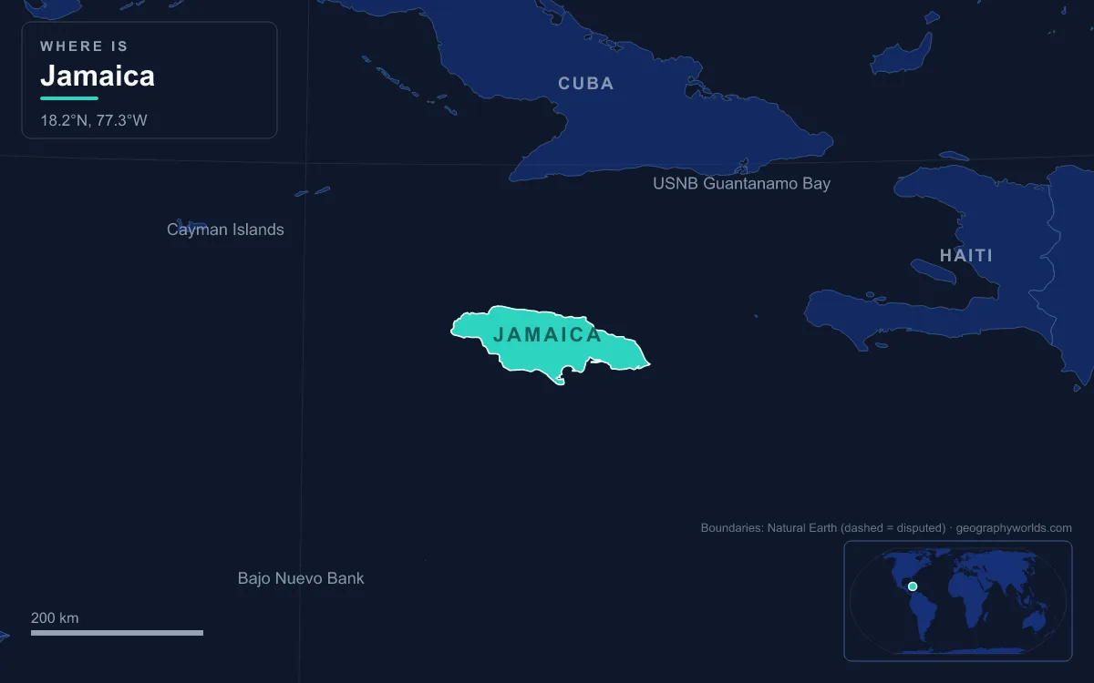
Jamaica is in North America. The island lies in the northern Caribbean Sea, in the Greater Antilles, about 145 km south of Cuba and 191 km west of Hispaniola, and every standard continental scheme counts the Caribbean islands as part of North America. The nearest South American coast, Colombia's Guajira Peninsula, is roughly 780 km away across open sea. The United Nations places Jamaica in its "Caribbean" subregion of the Americas. Jamaica also plays in CONCACAF, the North American, Central American and Caribbean football confederation, and helped found the Caribbean Community, CARICOM, in 1973.
Where North America Ends: the Darién Gap and the West Indies Rule
A continent is a convention as much as a landmass, so the question comes down to where geographers draw the line between the two Americas. On the mainland the answer is settled: North America's only land connection to South America runs through the Darién Gap on the border between Panama and Colombia. Everything north and west of that line, including all of Central America and Mexico, is North American. Some geologists prefer a boundary further north at the Isthmus of Tehuantepec in Mexico, but even under that stricter reading Jamaica sits far to the north-east of the dividing zone.
The islands are handled by a second convention. The West Indies, the chain of islands that curves from the Bahamas through the Greater and Lesser Antilles towards Venezuela, are considered part of North America. A handful of islands sit on South America's continental shelf, such as Trinidad, Aruba and Curaçao, and those are the cases that generate real debate. Jamaica is not one of them. It stands in the middle of the Caribbean basin, separated from the South American shelf by deep water, and every major atlas, encyclopedia and statistical agency groups it with the north.
Culture and climate drive much of the confusion. Jamaica is tropical, speaks English, and identifies first as Caribbean, while many people picture North America as Canada and the United States alone. Yet Cuba, Mexico and Guatemala are also tropical and also North American. Latitude makes the point: Jamaica lies between 17° and 19° north, roughly level with southern Mexico, while the northernmost point of mainland South America, Punta Gallinas in Colombia, lies at about 12.5° north.
Jamaica's Size and Shape: 10,991 km² and Blue Mountain Peak
Jamaica covers 10,991 km² (4,244 sq mi), which makes it the third-largest island in the Caribbean after Cuba and Hispaniola, and the largest island of the English-speaking Caribbean. At its greatest extent the island is 235 km long, and its width varies between 34 and 84 km. The easternmost point of the mainland is Morant Point in the parish of Saint Thomas; the western tip is at Negril, where limestone cliffs drop straight into the sea.
The interior is mountainous. The Blue Mountains in the east contain Blue Mountain Peak, 2,256 m (7,402 ft), the highest point in Jamaica and the tallest peak in the Caribbean outside Hispaniola. The range climbs to that height from the coastal plain in only about 16 km, one of the steepest general gradients anywhere. North of it rise the limestone John Crow Mountains, and the Blue and John Crow Mountains National Park, created in 1993, became a UNESCO World Heritage Site in 2015. Further west, a limestone plateau covers about two-thirds of the island, culminating in the sinkholes and conical hills of the Cockpit Country.

Jamaica's territory does not stop at the main island. The Pedro Bank, a large shallow bank of sand and coral about 80 km to the south and south-west, was annexed by Britain in 1863 and added to Jamaica in 1882. To the south-east, the Morant Cays lie about 51 km from Morant Point. These outlying cays help give Jamaica an exclusive economic zone of about 258,137 km², more than 23 times the land area, and all of it lies in the Caribbean Sea north of the South American shelf.
The Caribbean Plate and the Gonâve Microplate Under Kingston
Geology adds a twist that sometimes gets cited as evidence for a "South American" Jamaica. The island does not sit on the North American tectonic plate. It lies within the zone of faulting that separates the Caribbean plate from the Gonâve microplate, a strip about 1,100 km long that runs from the Mid-Cayman Rise east to Hispaniola. East of Jamaica the main boundary is the Enriquillo–Plantain Garden fault zone, which reaches the island near the Plantain Garden River in Saint Thomas; to the west the main structure is the Walton fault zone. Both are left-lateral strike-slip faults, and the Enriquillo–Plantain Garden system alone takes up about 20 mm of motion a year.
That motion has shaped Jamaican history. An earthquake in 1692, estimated at magnitude 7.5, almost destroyed Port Royal at the mouth of Kingston Harbour. The 1907 Kingston earthquake, magnitude 6.2, damaged every building in the capital and killed about 1,000 people. The Cayman Trough just north-west of the island reaches 7,686 m, the deepest point in the Caribbean Sea.
None of this makes Jamaica South American. The Caribbean plate is a separate plate from the South American plate, and continents are not defined plate by plate in any case: large parts of California sit on the Pacific plate without anyone calling Los Angeles part of Oceania. Researchers expect the Gonâve microplate eventually to be accreted to the North American plate, so the long-term tectonic trend around Jamaica points north, not south.
Cuba, Hispaniola and the Cayman Islands: Jamaica's Nearest Neighbours
Jamaica has no land borders. Its nearest neighbours all lie to the north, east and west, and all are North American. Cuba is about 145 km to the north. Hispaniola, the island shared by Haiti and the Dominican Republic, lies about 191 km to the east across the Jamaica Channel, a strait about 190 km wide and up to 1,200 m deep. The Cayman Islands, a British Overseas Territory, are about 215 km to the north-west. Together with Puerto Rico, these islands make up the Greater Antilles, the larger islands of the Caribbean.
Kingston to Havana is roughly 820 km, and Kingston to Miami roughly 930 km, both great-circle figures calculated from city coordinates. The narrow gap to Cuba is what made Jamaica part of the same Spanish colonial system as Cuba and Hispaniola after Christopher Columbus reached the island in 1494, and later part of the British West Indies after England took it in 1655. Spain recognised English possession in the Treaty of Madrid of 1670.

How Far Is Jamaica From Colombia and Venezuela?
Wikipedia gives no official sea distance between Jamaica and South America, so we calculated it from coordinates. From Morant Point to Punta Gallinas, the northern tip of Colombia's Guajira Peninsula and of the South American mainland, the great-circle distance is roughly 780 km. Venezuela's Paraguaná Peninsula is roughly 920 km from the same point. Kingston to Cartagena in Colombia is about 850 km, and Kingston to Caracas about 1,350 km. Jamaica is more than five times as far from South America as it is from Cuba.
The one place where Jamaica and a South American country meet is at sea. Colombia and Jamaica share a maritime boundary defined by the Sanín-Robertson Treaty, signed in Kingston on 12 November 1993 by foreign ministers Noemí Sanín and Paul Douglas Robertson. Colombia reaches that far north because of its Caribbean island territories, not its mainland. The treaty also created a Joint Regime Area, a roughly triangular zone south-west of Jamaica where the two states jointly manage fishing and seabed resources; it contains Alice Shoal, about 260 km south-west of the main island. The treaty treats Serranilla Bank and Bajo Nuevo Bank, which lie inside the zone, as excluded from the joint area and under Colombian sovereignty. Sovereignty over the two banks remains disputed: the United States also claims them, and in 2012 the International Court of Justice ruled for Colombia against a claim by Nicaragua.
The historic ties run deeper than the boundary line. Simón Bolívar took refuge in Jamaica during the Colombian War of Independence and wrote his Jamaica Letter there in 1815, and the two countries established diplomatic relations in 1968. Shared history, though, has never moved Jamaica's continental classification.
The UN's Caribbean Subregion and Jamaica's Seat in CARICOM
The United Nations Statistics Division geoscheme, the system behind most international datasets, puts Jamaica in the "Caribbean" subregion of "Latin America and the Caribbean", inside the wider "Americas" region. The UN notes that it treats North America as made up of three subregions: Northern America, Central America (including Mexico) and the Caribbean. That makes Jamaica North American under the UN's own definition, even though its statistical tables often report the Caribbean with Latin America rather than with Canada and the United States.
Regional politics follows the islands, not the continents. Jamaica joined the West Indies Federation when it formed on 3 January 1958, but in a referendum on 19 September 1961, 54% of Jamaican voters chose to leave, which led to the federation's dissolution on 31 May 1962. Jamaica became independent on 6 August 1962. In 1973 it was one of the four founding members of the Caribbean Community, with Barbados, Guyana and Trinidad and Tobago, under the Treaty of Chaguaramas, which took effect on 1 August 1973. CARICOM's 15 member states include two on the South American mainland, Guyana and Suriname, so membership signals a Caribbean identity rather than a continental one.
CONCACAF, Copa América and Jamaica's Place on the Sporting Map
Sport offers the clearest everyday answer. The Jamaica Football Federation, founded in 1910, has been affiliated with FIFA since 1962 and with CONCACAF, the Confederation of North, Central America and Caribbean Association Football, since 1963. Jamaica qualified for the FIFA World Cup once, in 1998, through CONCACAF, and beat Japan 2–1 for its first World Cup win. The Reggae Boyz were runners-up in the CONCACAF Gold Cup in 2015 and 2017.
Jamaica has also played in South America's Copa América three times, in 2015, 2016 and 2024, but always as an invited guest from CONCACAF, never as a member of CONMEBOL. Those appearances are probably part of why the question is asked at all.
Taken together, the evidence points one way: Jamaica is a North American island country in the Caribbean, part of the Greater Antilles, grouped with the Caribbean by the UN, and tied by sea, sport and politics to its northern neighbours. For a closer look at the island's coordinates, parishes and coastline, see our guide to where Jamaica is, compare it with a genuine borderline case in whether Trinidad and Tobago is in North or South America, or read how its nearest large neighbour is classified in our explainer on Cuba.