

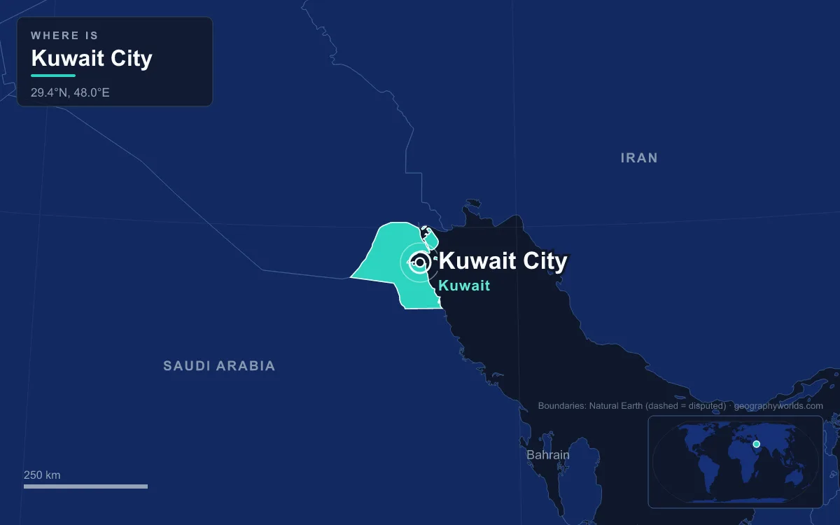
Kuwait City is the capital and largest city of Kuwait. It lies on the south shore of Kuwait Bay, a natural deep-water harbour at the north-western head of the Persian Gulf. In 2018 the metropolitan area had roughly three million people, more than 70 percent of the country, and a 2025 estimate puts it at about 3.4 million. Strictly speaking, the city has no administrative status of its own: the urban area now reaches into all six governorates, and the historic core sits in the Capital Governorate. What sets it apart is how fast it changed. In 1901 it was a pearling and trading port of about 15,000 people, and within one lifetime oil money had rebuilt it into a modern capital. Seven buildings on or near the old waterfront tell that story best.
Seif Palace, Built on the Shore in 1904
Kuwait began as a small fishing settlement. In the 1750s the Bani Utbah, migrants from central Arabia, set up a sheikhdom there, and the Al Sabah family has ruled it ever since. The town grew by taking trade away from Basra. During the Persian siege of Basra in 1775–1779, merchants and shipbuilders moved to Kuwait, and the routes linking India, Muscat and Persia with Baghdad and Aleppo came with them. Kuwaiti dhows went on to carry much of the trade between India, East Africa and the Red Sea.
By the rule of Sheikh Mubarak Al Sabah (1896–1915), the port was busy enough to be called the “Marseille of the Gulf”. In 1899 Mubarak signed the Anglo-Kuwaiti Agreement, which made the sheikhdom a British protectorate: Britain pledged to protect Kuwait, and in return foreign powers’ access to the sheikhdom was restricted. As delegations and merchants arrived, the ruler needed a proper seat of government, and in 1904 it was decided to build a palace facing the sea, the seif. Later rulers enlarged Seif Palace, first in 1917 and again in 1961, and by 1962 it housed the Amiri Diwan, the emir’s court. Its clock tower, faced with blue tiles and topped by a gold-plated roof, is the building most people remember. A missile hit the tower during the 1990–91 Gulf War and destroyed the room holding the clock dials. The British firm Smith of Derby replaced the clock.

Souq Al-Mubarakiya, the Market Before Oil
A short walk inland from the palace, between Abdullah Al-Mubarak, Abdullah Al-Salem and Palestine streets, lies the trading centre of the old town. Souq Al-Mubarakiya has been there for at least 200 years, and before oil this was where the port’s money changed hands. The pearling economy that fed it was already failing when the travel writer Freya Stark visited in 1937. She wrote that poverty had settled over the town, hit both by the decline of pearling and by a Saudi trade blockade. Several merchant families had left in the early 1930s.
Today the lanes sell Persian carpets, oud and musk perfumes, gold, dates, spices and fish. Two small free museums sit inside the souq: the Sheikh Mubarak Kiosk and Kuwait’s first pharmacy. Near the Sea Mosque, open-air cafés spray water mist over the tables in summer. That matters here. Kuwait City has a hot desert climate, with average highs above 45 °C for three months of the year and heatwave days over 50 °C. The souq was damaged during the Iraqi occupation in 1990 and later restored. On 31 March 2022 a large fire destroyed part of it, and in March 2024 Kuwait Finance House signed a contract, worth about KD 8 million, to rebuild some 17 buildings.
The Kuwait Towers and the 1970s Water Network
Oil changed the city. Commercial reserves were found in 1938, and by 1952 Kuwait was the largest oil exporter in the Gulf. A public-works programme started in 1950, the state approved a new master plan in 1952, and in 1957 the city wall, built around 1921, was pulled down so the city could spread across the desert. The biggest practical problem was water in a country with no rivers. In 1965 the government hired the Swedish engineering firm VBB to design a supply network. By 1976 its chief architect, Sune Lindström, had built 31 concrete “mushroom” water towers in five groups across the city, each holding 3,000 cubic metres of desalinated water.
For the sixth and most visible site, a promontory on the Arabian Gulf Street coast, Sheikh Jaber Al-Ahmad asked for something grander. He chose a design by the Danish architect Malene Bjørn from three shortlisted options. The Kuwait Towers were inaugurated in March 1979. The main tower is 187 metres tall and carries two spheres. The lower one holds a 4,500-cubic-metre water tank beneath a restaurant, and the upper one, 123 metres above sea level, turns a full circle every 30 minutes. The second tower, 147 metres high, stores water, and the thin third tower holds the equipment that lights the other two. Together with Lindström’s towers, they won an Aga Khan Award for Architecture in 1980. They were closed for repairs from 2012 until 8 March 2016.

Jørn Utzon’s National Assembly Building, 1982
Kuwait became independent in June 1961, when the British protectorate ended, and Sheikh Abdullah Al-Salim Al-Sabah took the title of emir. It held its first parliamentary elections in 1963, the first Gulf state to have both a constitution and an elected parliament. At first the assembly met in temporary premises. In late 1969 the government invited Jørn Utzon, architect of the Sydney Opera House, to enter a competition for a permanent building on the waterfront.
Utzon designed the complex as a small walled city. Departments open off a central hall laid out like a covered bazaar street, which leads to a covered square facing the sea. Budget cuts, redesigns and delays followed. The emir approved construction in 1975, the conference hall was dropped from the plans, and the mosque was moved inside the complex. The building was finished in 1982 under Utzon’s son Jan. Its sagging roofs look like fabric moving in the wind. The building’s history has followed the country’s politics. Parliament was suspended in 1976 and again in 1986, and in 2006 women voted in a general election for the first time.
The Grand Mosque Across From Seif Palace
Opposite Seif Palace stands the largest mosque in Kuwait. Work on the Grand Mosque started in 1979, and it was completed on Eid al-Fitr of 1407 AH, which sources date to 1986 or 1987. The site covers 45,000 square metres, of which the building takes up 20,000. The main prayer hall is 72 metres on each side and holds up to 10,000 men, with a separate hall for 950 women. The dome is 26 metres across and 43 metres high and is decorated with the 99 names of God. Daylight comes in through 144 windows, and the minaret at the north-west corner is modelled on Andalusian examples.
The mosque went up during the tense 1980s. The Souk Al-Manakh stock market crash had hit the economy, and the city suffered the 1983 bombings and an attempt on the life of Emir Jaber in 1985. The Kuwait National Museum, founded in 1957 and housed from 1983 in a courtyard complex by the French architect Michel Ecochard, is also in the city centre.
Liberation Tower, Finished After 1991
When Iraqi forces invaded on 2 August 1990, a 372-metre telecommunications tower was about half built in the city centre. Work stopped for the seven months of occupation. More than 1,000 Kuwaiti civilians were killed in that time, and retreating troops set fire to the oil wells, leaving more than 500 oil lakes in the desert. The structure itself was not damaged, and building resumed after the Iraqi army was driven out on 26–27 February 1991. When it was completed in 1993, the planned name, Kuwait Telecommunications Tower, was dropped and it opened as the Liberation Tower. It is not open to tourists, but the complex at its base houses a government service centre where residents deal with several ministries.
Al Hamra Tower, the 414-Metre Curve of 2011
The newest landmark shows where the money now goes: office towers for a financial centre whose currency, the Kuwaiti dinar, is the highest-valued currency unit in the world. Petroleum still makes up about 43 percent of GDP and 70 percent of export earnings. Al Hamra Tower was built between 2005 and 2011 to a design by Skidmore, Owings & Merrill. At 414 metres it is Kuwait’s tallest building and the tallest curved concrete skyscraper in the world. Its twisting south face is clad in brushed limestone, and the other three sides in glass. Inside is a column-free lobby 24 metres tall, and in 2011 Time magazine listed the tower among the best inventions of the year.
Taken together, the seven buildings trace the city’s course. There is the sea-facing palace of the pearling years and the market that survived the invasion. The towers, parliament and mosque came from 1970s oil wealth, and the telecom tower was renamed for liberation. Behind the waterfront, the metropolitan area now reaches into all six governorates, served by Kuwait International Airport and the ports of Shuwaikh and Ahmadi. To see how this shoreline fits the wider sea, read our guide to the Persian Gulf, then look at the countries that border Kuwait. The Kuwait country guide covers the rest of the emirate beyond its capital.
Quick Facts About Kuwait City
- Country: Kuwait
- Continent: Asia (Middle East)
- Country population: approximately 5.1 million
- Capital city status: Kuwait City is the capital of Kuwait, the seat of national government, and the location of foreign embassies, parliament, and the head of state's official residence.
Frequently Asked Questions
What is the capital of Kuwait?
The capital of Kuwait is Kuwait City. Kuwait City is the seat of national government, hosts most foreign embassies and consulates, and is typically where the head of state and parliament are located.
What continent is Kuwait City in?
Kuwait City, the capital of Kuwait, is located in Asia, in the Middle East region. As Kuwait's capital, Kuwait City serves as the country's primary connection to the broader Asian political, economic, and cultural sphere.
Why is Kuwait City the capital of Kuwait?
Kuwait City was chosen as the capital of Kuwait for reasons that typically combine geography, history, and politics. Capital city selections often reflect a desire for centrality (being accessible from across the country), historical importance (being a longstanding seat of government or culture), or neutrality (being acceptable to multiple regions or ethnic groups within the country). The specific reasons for Kuwait City's designation are detailed in the city's history above.
What is Kuwait City known for?
As the capital of Kuwait, Kuwait City is best known for housing the country's central government institutions — parliament, presidential or royal residences, supreme court, and key ministries. It is also typically a major cultural and economic center within Kuwait, hosting national museums, embassies, and signature monuments. The introduction and history sections above provide detailed coverage of the city's specific notable institutions and landmarks.
Related Pages
- Kuwait Country Guide — full geography, climate, economy, and culture overview
- Flag of Kuwait — meaning, history, and design of Kuwait's national flag