

The capital of Zambia is Lusaka, the country’s largest city, which stands on the high central plateau of south-central Zambia at about 1,280 metres above sea level. The 2022 census counted 2,204,059 people in the city. Lusaka began in 1905 as a water stop on a colonial railway, was chosen in 1931 as the planned capital of Northern Rhodesia, took over from Livingstone in 1935 and became the capital of independent Zambia in 1964. It is still where the country’s main highways meet and where its government, banks and stock exchange are based.
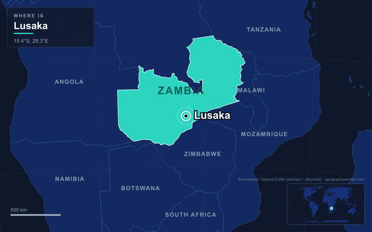
Lusaka is too young to have old quarters in the European sense, but its districts line up remarkably neatly with the stages of its history. Walking out from the railway track to the suburbs is a walk forward in time.
Cairo Road and the Railway, Where the 1905 Water Stop Grew
Start where the city started, beside the tracks. In 1905 the Mashonaland Railway Company pushed the line north 452 km from Kalomo to the mining town of Broken Hill, now Kabwe, as part of the British South Africa Company’s drive toward the Copperbelt. A halt for steam engines to take on water was set up here and named after Lusaaka, chief of a nearby Lenje village. Afrikaner farmers settled around the siding, and by 1913 a few stores and a hotel had opened. The farmers persuaded the company to recognise Lusaka as a town run by an elected Village Management Board, and its territory was simply a strip along the railway about 5 km long and 1.5 km wide.
That strip is today’s central business district. Cairo Road, one block west of the tracks, runs for about 1.8 km between the Kabwe Roundabout in the north and the Kafue Roundabout in the south as a dual carriageway with trees down the middle. Its name records an imperial ambition: it was meant to be a link in Cecil Rhodes’s dream of a Cape to Cairo road through British territory. Four of the five tallest buildings in Zambia stand on it, led by the 23-storey Findeco House at about 90 metres. West of Cairo Road lie the Central Market and New City Market, and heavy lorries are banned from the road itself and sent along Lumumba Road instead. Even so, the lack of ring roads keeps Cairo Road congested for much of the day.
Up to Ridgeway and Cathedral Hill: Adshead’s Planned Capital
Walk east across the railway toward the government quarter. This part of Lusaka exists because of a telegram. In March 1929 the Colonial Office in London advised Northern Rhodesia to move its capital from Livingstone, citing “communications” and “health”. Governor James Maxwell and his colleague David Alexander toured candidate sites and favoured Lusaka because it sat on the railway and at the crossing of the Great North Road and the Great East Road. The Colonial Office sent the town planner Stanley Adshead, a professor at University College London, along with a water engineer. Adshead even looked at the Copperbelt, but the mining companies and the government distrusted each other and both preferred a little distance. The engineer found enough groundwater, and the legislative council approved Lusaka in July 1931.
Building went slowly. The Great Depression drained the budget, and Governor Ronald Storrs spent much of his energy on a grand Government House whose projected £43,000 cost was more than a tenth of the whole Lusaka project; London ordered it scaled back in late 1933. In April 1934 Prince George, fourth son of King George V, laid the foundation stone of the administrative buildings. Lusaka formally became the capital in May 1935, timed to coincide with George V’s silver jubilee, and a special train moved the entire government up from Livingstone in a single weekend. Livingstone, which had feared losing business, was consoled with the role of tourism capital beside the Victoria Falls.
Adshead laid out a spacious, low-density town with room to grow inward, and he wrote racial segregation into the plan, putting African housing and services on the southern edge. Today the Cathedral Hill and Ridgeway neighbourhoods hold State House, the ministries and the Anglican Cathedral of the Holy Cross, completed in 1962 in the Cathedral Hill neighbourhood and still the seat of the Diocese of Lusaka.

Independence Avenue and Woodlands: The Capital of 1964
Continue east along Independence Avenue and the street names change from colonial to national. Lusaka’s status was nearly lost in the 1950s. In 1953 Britain merged Northern Rhodesia, Southern Rhodesia and Nyasaland into the Federation of Rhodesia and Nyasaland and made Salisbury, now Harare, the federal capital. Lusaka stayed the territorial capital, but many departments and businesses moved south, and falling copper prices in the later 1950s brought heavy unemployment. After a civil disobedience campaign in 1962 led by Kenneth Kaunda’s United National Independence Party, Britain agreed a constitution that gave Africans control of the legislature. The federation ended in 1963, and on 24 October 1964 Northern Rhodesia became the Republic of Zambia with Lusaka as its capital.
Independence brought a burst of building: new government offices, a university and an airport. It also gave the city a regional role. With Mozambique, Angola, Southern Rhodesia and South Africa still under white minority rule, exiled activists from those territories settled in Lusaka, and one historian later called it the centre of anti-colonial resistance for southern Africa. The Oliver Tambo Heritage House, named for the African National Congress leader, is one of the city’s museums. In April 1969 the city hosted the Fifth Summit Conference of East and Central African States, whose Lusaka Manifesto called for majority rule across southern Africa and was later adopted by the Organisation of African Unity and the United Nations. For the tenth anniversary of independence in 1974, Kaunda had the sculptor James Butler make the Freedom Statue, a 12-foot figure breaking his chains that also appears on Zambian kwacha banknotes.
Beyond the government area, Independence Avenue leads into Woodlands, the principal residential area for the city’s rich elite and wealthy expatriates, with Ibex Hill and Rhodes Park nearby in the east of the city.
Out Along the Great East Road: Campus, Malls and the Airport
Turn north-east onto the Great East Road and you pass the institutions of the independent state. The University of Zambia, the country’s oldest and largest, was established in 1965 and opened on 12 July 1966; its main Great East Road campus lies about 7 km from the city centre. The same road now carries the city’s retail boom, with the Arcades, East Park and Manda Hill shopping centres among the largest in Zambia.
At the far end, about 27 km from the centre in neighbouring Chongwe District, is Kenneth Kaunda International Airport. It opened in 1967 as Lusaka International Airport and took the first president’s name in 2011. A US$360 million expansion funded by a loan from China’s Exim Bank produced a new terminal, officially opened on 5 August 2021, with capacity for about six million passengers a year. The airport has no rail link, and Lusaka has no commuter trains at all.
Chilenje and Matero: The Townships Planned and Unplanned
Head back south and west of the centre and the other Lusaka appears, the city where most residents actually live. Colonial Lusaka treated Africans as temporary workers. In 1938 a report by the finance expert Alan Pim noted that of about 10,000 Africans in the city only 1,500 had formal housing, and families were generally barred from joining workers. The African Housing Ordinance of 1948 finally allowed permanent African suburbs, including homes for married couples, and the new African Housing Board built New Chilenje and Matero.
Chilenje holds one of the city’s most modest national monuments. Kenneth Kaunda lived in House 394, a small two-bedroom home, from January 1960 to December 1962 and ran the independence campaign from it. It was restored to its 1962 state and opened as a museum by Kaunda himself on 23 October 1968, with the house next door displaying the history of Lusaka.

Formal housing never kept pace with migration. Kalingalinga, east of the centre, was one of Lusaka’s earliest squatter settlements, and after the copper industry declined from the 1970s, people moved from the Copperbelt to the capital, pushing growth to around 4 per cent a year in the 1990s. By 2015 about 70 per cent of residents lived in unplanned settlements, mainly to the west, south and north. The mix of newcomers also produced the city’s street language, Town Nyanja, which is built on Nyanja and borrows from English, Bemba and Nsenga.
Beneath the Streets: Lusaka’s Dolomite and Its Groundwater
The last stop is underfoot, and it explains why the capital is here at all. The city sits on schist in the north and limestone with dolomitic marble in the south, down to about 120 metres. These rocks hold more groundwater than the crystalline basement found across most of Zambia, which is what the 1930s water engineer was looking for. The limestone has also formed underground karst that swallows surface water, so Lusaka has no major river. It lies on a drainage divide: the north-east drains to the Chongwe River and the west and south to the Kafue, both tributaries of the Zambezi. The non-clay soils filter little before water reaches the aquifers.
Altitude sets the climate. Lusaka has a subtropical monsoon climate with a warm rainy season from November to March, a dry winter from April to August when July averages 14.9 °C, and a hot season in September and October; October, the hottest month, sees average daily highs of about 32 °C.
The city is now working to catch up with itself. A development plan prepared with the Japan International Cooperation Agency, an urban and regional planning act passed in 2015 and a road programme begun in 2018 all target the gap between Adshead’s spacious plan and the city of 2.2 million that grew around it. Lusaka is coterminous with Lusaka District and is capital of Lusaka Province, the smallest of Zambia’s ten provinces but the most populous. For how that province fits into the rest of the country, see our Zambia country guide.
Quick Facts About Lusaka
- Country: Zambia
- Continent: Africa (Southern Africa)
- Country population: approximately 22.5 million
- Capital city status: Lusaka is the capital of Zambia, the seat of national government, and the location of foreign embassies, parliament, and the head of state's official residence.
Frequently Asked Questions
What is the capital of Zambia?
The capital of Zambia is Lusaka. Lusaka is the seat of national government, hosts most foreign embassies and consulates, and is typically where the head of state and parliament are located.
What continent is Lusaka in?
Lusaka, the capital of Zambia, is located in Africa, in the Southern Africa region. As Zambia's capital, Lusaka serves as the country's primary connection to the broader African political, economic, and cultural sphere.
Why is Lusaka the capital of Zambia?
Lusaka was chosen as the capital of Zambia for reasons that typically combine geography, history, and politics. Capital city selections often reflect a desire for centrality (being accessible from across the country), historical importance (being a longstanding seat of government or culture), or neutrality (being acceptable to multiple regions or ethnic groups within the country). The specific reasons for Lusaka's designation are detailed in the city's history above.
What is Lusaka known for?
As the capital of Zambia, Lusaka is best known for housing the country's central government institutions — parliament, presidential or royal residences, supreme court, and key ministries. It is also typically a major cultural and economic center within Zambia, hosting national museums, embassies, and signature monuments. The introduction and history sections above provide detailed coverage of the city's specific notable institutions and landmarks.
Related Pages
- Zambia Country Guide — full geography, climate, economy, and culture overview
- Flag of Zambia — meaning, history, and design of Zambia's national flag