
China borders 14 countries by land: Russia, Mongolia, North Korea, Vietnam, Laos, Myanmar, Bhutan, Nepal, India, Pakistan, Afghanistan, Tajikistan, Kyrgyzstan and Kazakhstan. Wikipedia’s table of land borders puts the total at about 22,147 km, the longest land frontier of any country, and only Russia matches China’s count of 14 neighbours. The longest single border is with Mongolia (about 4,677 km), and the shortest is with Afghanistan at the tip of the Wakhan Corridor, 76 km in the table and 92 km in the article on that border. These lines were not all drawn at once. Each one reflects a particular treaty or war, from the Qing–Russian settlements of the 17th century to the Central Asian deals finished in 2011, and two of them, with India and Bhutan, still have no agreed boundary.
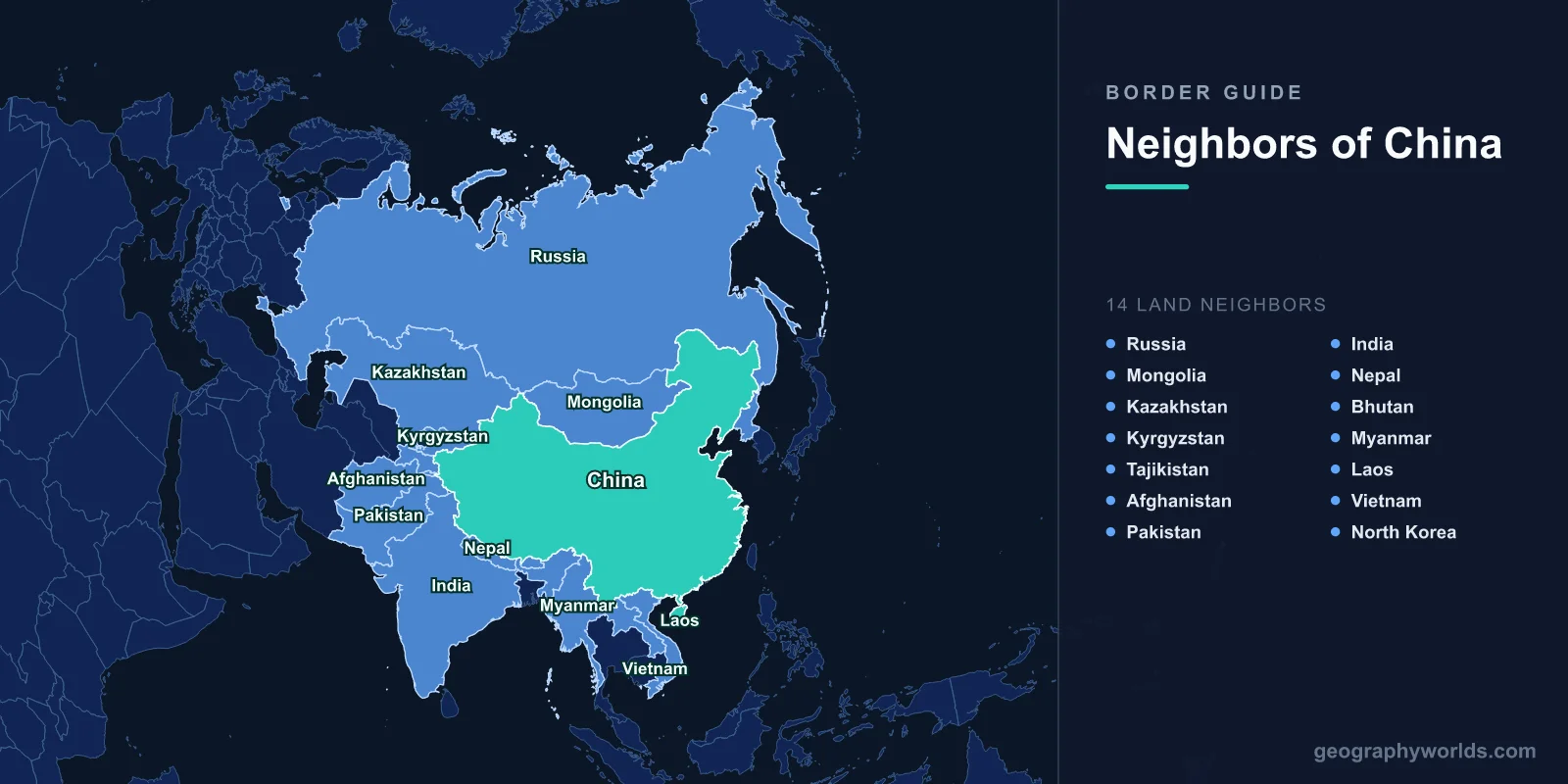
This guide takes the borders in the order they were settled, which explains far more about why they run where they do than a list by length.
Nerchinsk 1689 to Tarbagatai 1864: the Qing–Russian treaties
China’s oldest modern borders came from the collision between the Qing dynasty and a Russian empire pushing east across Siberia. The Treaty of Nerchinsk of 1689 drew the first line, along the Argun and Shilka rivers and then over the Stanovoy Mountains to the Sea of Okhotsk, leaving the land north of the Amur up to the Stanovoy range to the Qing. The Treaty of Kyakhta of 1727 fixed a line from the Irtysh to the Argun, which today is mostly the Mongolia–Russia border, because Mongolia was then ruled by the Qing.
The balance shifted in the mid-19th century, while the Qing were fighting the Taiping Rebellion. The Treaty of Aigun of 1858 moved the border south to the Amur River, reversing Nerchinsk, and the Convention of Peking of 1860 gave Russia the land east of the Ussuri, now Primorsky Krai and southern Khabarovsk Krai. That cut China off from the Sea of Japan and gave Russia a short border with Korea. In China both are denounced as unequal treaties. In Central Asia, the Treaty of Tarbagatai of 1864 drew the western line, most of which is now China’s border with Kazakhstan, Kyrgyzstan and Tajikistan, and the Treaty of Saint Petersburg of 1881 returned the eastern Ili basin, which Russia had occupied since 1871.
The result is the river border seen today. From the tripoint with Mongolia the Russian border follows the Argun, the Amur and the Ussuri, crosses Lake Khanka and ends on the Tumen River a few kilometres from the Pacific. A separate section of about 55 km runs through the snow-covered Altai Mountains in the far west.
Tientsin 1885 to Simla 1914: lines drawn by France and Britain
China’s southern borders were drawn mostly with European colonial powers. After the Sino-French War, the Treaty of Tientsin of 1885 provided for a joint commission to mark the border between China and Tonkin, and the lines it agreed in 1887 and 1895 are still the basis of the China–Vietnam border. The China–Laos line was delimited on 20 June 1895, after France added Laos to French Indochina. With Britain, which ruled Burma from India, China signed a treaty in 1894 covering the southern half of the Burma border.
In the Pamirs, Britain and Russia agreed in 1895 to make Afghanistan’s Wakhan Corridor a buffer between their empires, and that is why Afghanistan reaches China at all, along a line of 76 to 92 km high in the mountains. China was not a party to that agreement. Further east, Britain proposed the Macartney–MacDonald Line for the Karakoram in 1899, but China never replied to it.
The most consequential line of the period was drawn without China’s agreement. At the Simla Conference, British and Tibetan representatives exchanged maps and notes on 24–25 March 1914 that set the McMahon Line, which runs 890 km from the corner of Bhutan to the Isu Razi Pass on the Burmese border, mostly along the crest of the Himalayas. The Republic of China initialled the overall Simla Convention but then repudiated it. The McMahon Line guide traces how that 1914 map still shapes the eastern Himalaya.
The treaty wave of 1960–1964: Myanmar to Afghanistan
The People’s Republic, founded in 1949, settled most of its land borders in a burst of treaties between 1960 and 1964. Burma came first, with a treaty on 28 January 1960 and a full boundary treaty on 1 October 1960, under which each side gave up small areas. Nepal signed on 21 March 1960 and agreed a final boundary treaty on 5 October 1961, recognising the “traditional customary line” through the Himalayas, a line that runs over the summit of Mount Everest. Pillars were placed and a protocol was signed in January 1963.
Mongolia came next. Mongolia had declared independence in 1921, and China recognised it after a plebiscite in 1946. The two countries signed a treaty on 26 December 1962, demarcated the 4,600-km line across the Gobi in 1963–64, and signed a final treaty with detailed maps on 30 June 1964. The guide to Mongolia’s neighbours covers that border from the north. With North Korea, two secret treaties in 1962 and 1964 set the line along the Yalu and Tumen rivers and divided Mount Paektu and its crater lake, Heaven Lake, between the two states.

Pakistan and China signed their agreement on 2 March 1963, with Chen Yi and Zulfikar Ali Bhutto as signatories. It broadly followed the 1899 line as modified by Lord Curzon in 1905, with the Khunjerab Pass as the main crossing. India does not recognise it, since India claims all of the former princely state of Jammu and Kashmir, including the Shaksgam Valley that the agreement places in China. Afghanistan and China agreed and demarcated their Wakhan boundary the same year, in 1963.
1962 and 1969: wars with India and the Soviet Union
Not every border was settled at a negotiating table. India and China fought a short war in October and November 1962 in two theatres about 1,000 km apart: Aksai Chin in the west and the North-East Frontier Agency, now Arunachal Pradesh, in the east. India relied on the Johnson Line in the west and the McMahon Line in the east, and China recognised neither. China declared a unilateral ceasefire on 20 November 1962 and pulled back in the east, but kept Aksai Chin. The line separating the two sides became known as the Line of Actual Control.

Seven years later the Sino-Soviet split turned violent on the Ussuri. In March 1969 Chinese and Soviet troops clashed on Zhenbao (Damansky) Island, the most serious of a series of clashes that lasted about seven months and brought the two countries close to full-scale war. The border stayed heavily militarised until it slowly reopened after 1982.
After 1991: Russia, Central Asia and Vietnam finish the job
The 1991 Sino-Soviet Border Agreement, signed on 16 May 1991, restarted talks just months before the Soviet Union broke up, leaving Russia, Kazakhstan, Kyrgyzstan and Tajikistan to finish them. Kazakhstan signed its treaty in Almaty on 26 April 1994, with more agreements in 1997 and 1998. The demarcated line is 1,782.75 km long, and a strip east of Lake Zhalanashkol that had been fought over in 1969 went to China. Kyrgyzstan delimited its border in 1996, but opposition at home delayed the final settlement until 2009. In 2011 Tajikistan ratified a 1999 deal and a 2002 supplementary agreement that gave China 200 km² and 1,122 km² of the Pamirs, while China dropped claims to more than 28,000 km².
With Russia, the last disputes were settled by the 2004 Complementary Agreement on the eastern section. Russia handed over Tarabarov (Yinlong) Island, about half of Bolshoy Ussuriysky Island and part of Abagaitu Islet. Both parliaments ratified it in 2005, and the transfer took place on 14 October 2008.
In the south, China and Vietnam had fought a brief war in early 1979, and skirmishes went on through the 1980s. After relations were normalised in November 1991, both sides accepted the colonial-era lines of 1887 and 1895 and signed a land boundary treaty on 30 December 1999. Demarcation was finished in 2008. The China–Laos border was re-surveyed and demarcated in April 1992.
India and Bhutan: China’s two borders without a treaty
Two of China’s 14 land borders still have no agreed line. With India, the two countries agreed in 1993 to respect the Line of Actual Control without marking it on the ground, and each still claims land the other holds: India claims Aksai Chin, and China claims Arunachal Pradesh, which it calls Zangnan. The problem flared again in 2020. On 15–16 June, hand-to-hand fighting in the Galwan Valley in Ladakh killed 20 Indian soldiers, and in February 2021 China acknowledged four deaths on its side. Our explainer on the China–India Line of Actual Control follows the line sector by sector.
Bhutan has never had formal diplomatic relations with China, and their border, 470 or 477 km long depending on the source, has not been finally agreed. China claims areas totalling about 1,504 km² along it. A 1998 agreement committed both sides to keeping the peace there, but Chinese road-building has caused repeated tension. The best known case was the 2017 standoff at Doklam, where the borders of Bhutan, India and China meet; Bhutan protested a Chinese road on 29 June that year.
In short, China’s land borders were drawn in four broad periods: Qing treaties with Russia, colonial lines with France and Britain, a wave of agreements in the early 1960s, and a final round of settlements after 1991, with the Himalayan borders still open. For how China’s total compares with other large countries, see our ranking of countries with the longest land borders.