
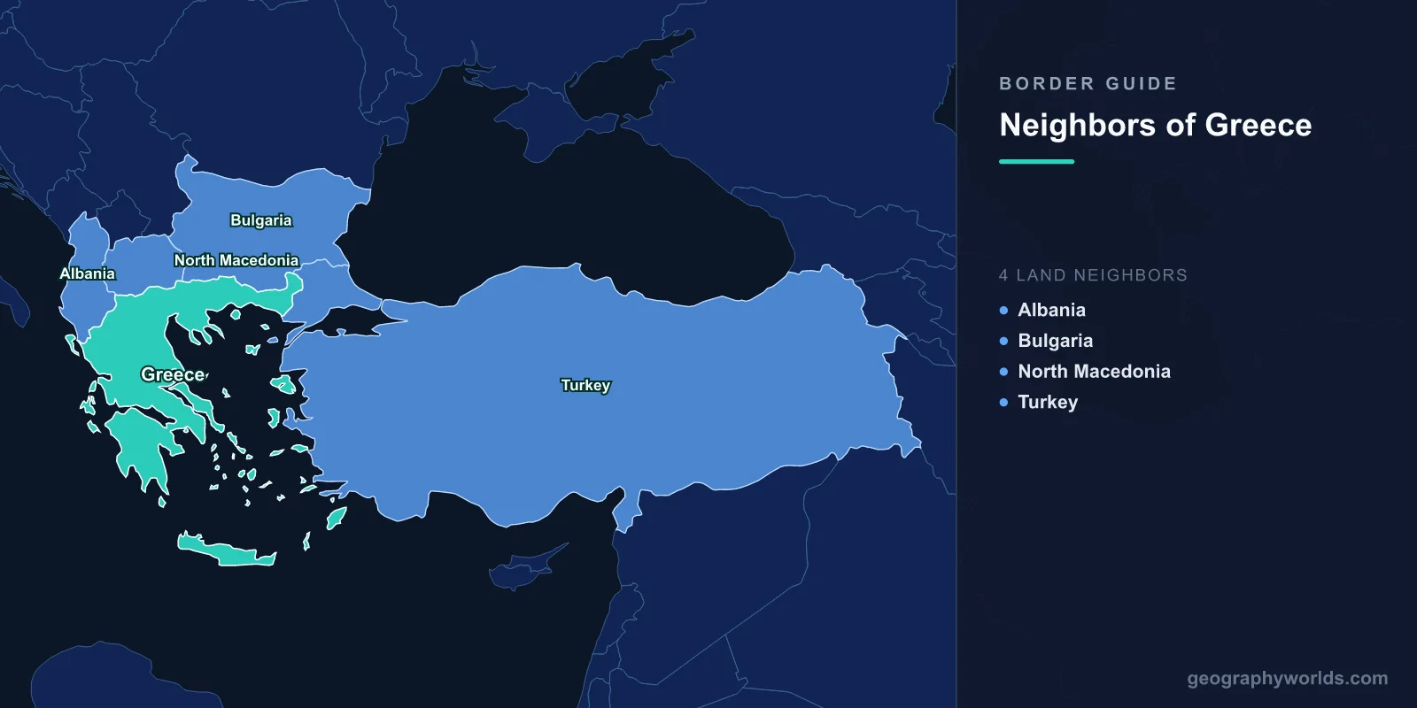
Greece shares land borders with four neighboring countries: Albania, North Macedonia, Bulgaria, and Turkey, along a combined land frontier of roughly 1,110 km. All four borders run across the northern and northeastern edge of the Greek mainland, while the rest of the country faces open water. That mix of mountain frontiers and a vast coastline gives Greece one of the most distinctive geographic profiles in Europe, with a small number of land neighbors but a large circle of maritime ones.
The Four Land Neighbors at a Glance
Greece occupies the southern tip of the Balkan Peninsula, so every one of its land borders sits along the north. Moving roughly from west to east, the four bordering nations are:
- Albania — to the northwest, separated in part by the rugged Pindus mountain range and the historic region of Epirus.
- North Macedonia — to the north, across a frontier that runs near the Prespa Lakes and the Greek region of Macedonia.
- Bulgaria — to the north and northeast, divided largely by the forested Rhodope Mountains.
- Turkey — to the northeast, where the Evros (Maritsa) River forms most of the boundary in the region of Thrace.
Together these borders frame the only land routes into and out of Greece. Everywhere else, the country meets the Ionian, Aegean, and Mediterranean seas. You can explore the country in much greater depth in our Greece country guide.
Albania: The Northwestern Mountain Frontier
The border with Albania stretches about 212 km through some of the most mountainous terrain in the southern Balkans. This is the part of Greece known as Epirus, a land of deep valleys, alpine villages, and a significant Greek-speaking minority living on the Albanian side around the towns of the south. The main road crossing at Kakavia connects the Greek city of Ioannina with southern Albania and the port of Saranda, a route popular with both freight and summer tourists.
Historically the Albanian frontier was one of the most heavily militarized in Europe during the Cold War, when communist Albania sealed itself off from its neighbors. Today it is an open, EU-adjacent border, though Albania is still a candidate for European Union membership rather than a full member, so crossings here involve passport and customs checks that do not apply between Greece and its EU neighbors.
North Macedonia: The Border That Changed Its Name
To the east, the border with North Macedonia runs for roughly 234 km. For nearly three decades the two countries disputed the very name "Macedonia," which Greece associates with its own northern province and the legacy of Alexander the Great. The 2018 Prespa Agreement finally resolved the issue when the former Yugoslav republic officially renamed itself the Republic of North Macedonia, reopening political and economic cooperation across a border anchored by the shared Prespa Lakes.
The main crossing at Evzoni–Bogorodica lies on the highway corridor linking Thessaloniki to Skopje, one of the busiest north–south arteries in the Balkans. North Macedonia, like Albania, is an EU candidate country, so this remains an external border of the European Union with full frontier controls.
Bulgaria: The Longest Land Border
Greece and Bulgaria share a frontier of around 472 km, the longest of the four land borders. Much of it follows the crest of the Rhodope Mountains, a forested and sparsely populated range that historically made the boundary difficult to cross. Today both nations are members of the European Union, and Bulgaria joined the Schengen Area's land-border framework in 2025, easing movement still further. The Promachonas–Kulata crossing on the route between Thessaloniki and Sofia is the busiest gateway, carrying heavy trade and tourist traffic between the two regions. A second important link, the Makaza pass, opened in 2013 to shorten the drive between Greek Thrace and southern Bulgaria.
Turkey: The Northeastern Border and the Aegean
The border with Turkey is about 192 km long and is the most geopolitically sensitive of the four. Most of it is defined by the winding course of the Evros River in the region of Thrace, with the rest meeting the Aegean Sea. The main road crossing at Kipoi–İpsala links Greek Thrace with Turkey's European provinces.
Beyond the land boundary, Greece and Turkey are separated by a maze of Aegean islands, many lying just a few kilometers off the Turkish coast. This proximity has fueled long-standing disputes over territorial waters, airspace, and continental-shelf rights, making Greek–Turkish relations a defining feature of the eastern Mediterranean. The Evros frontier has also become a focal point for migration into the European Union, prompting fencing and heavy patrols along parts of the river.
Maritime Neighbors Across the Sea
Because Greece is surrounded by water on three sides and has more than 6,000 islands (around 227 of them inhabited), it shares maritime boundaries with several countries it does not touch by land. Its principal sea neighbors include:
- Italy — across the Ionian Sea to the west, with busy ferry routes linking ports such as Patras and Igoumenitsa to Bari and Ancona.
- Cyprus — a culturally and linguistically Greek nation lying to the southeast in the eastern Mediterranean.
- Egypt and Libya — across the Mediterranean to the south, with whom Greece negotiates exclusive economic zone (EEZ) boundaries over potential offshore gas reserves.
These maritime relationships matter enormously for shipping, fishing, energy exploration, and tourism, even though no land bridge connects them to Greek soil. Greece's 2020 EEZ agreement with Italy and its ongoing maritime negotiations with Egypt show how important sea borders are to a nation whose coastline runs for more than 13,000 km.
Why Greece's Borders Matter
Greece's position at the meeting point of Europe, Asia, and the Mediterranean has shaped its history for thousands of years. The northern mountain borders historically protected the Greek heartland while channeling invasions and trade through a handful of passes. Today those same frontiers mark the southeastern edge of the European Union and, in places, the Schengen Area, making Greece a crucial gateway for trade, travel, and migration between the EU and the wider Balkans, Turkey, and the Middle East.
Key Facts
- Number of land neighbors: 4 (Albania, North Macedonia, Bulgaria, Turkey)
- Total land border length: approximately 1,110 km
- Longest border: Bulgaria, about 472 km
- Shortest border: Turkey, about 192 km
- EU member neighbors: Bulgaria (Albania, North Macedonia, and Turkey are non-members)
- Maritime neighbors: Italy, Cyprus, Egypt, Libya, and others
- Coastline: over 13,000 km, among the longest in Europe
Frequently Asked Questions
How many countries border Greece?
Greece borders four countries by land: Albania, North Macedonia, Bulgaria, and Turkey. It also has maritime neighbors including Italy, Cyprus, Egypt, and Libya across the surrounding seas.
Which country has the longest border with Greece?
Bulgaria shares the longest land border with Greece, at roughly 472 km, much of it running through the Rhodope Mountains in the north.
Does Greece border Turkey by land or by sea?
Both. Greece and Turkey share a land border of about 192 km in Thrace, mostly along the Evros River, and they are also separated by sea throughout the Aegean, where Greek islands lie close to the Turkish mainland.
Which of Greece's neighbors are in the European Union?
Among Greece's four land neighbors, only Bulgaria is a full EU member. Albania and North Macedonia are EU candidate countries, while Turkey is not a member, so those three remain external borders of the Union.