

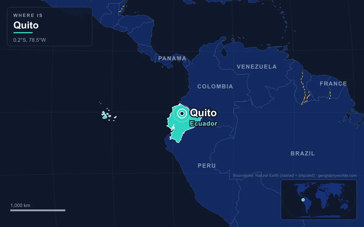
Quito is the capital of Ecuador, built in a long Andean valley on the eastern slopes of the Pichincha volcano at about 2,850 metres above sea level, which makes it one of the two highest national capitals in the world. The city had 1,763,275 inhabitants in 2022 and its metropolitan district about 2.89 million, second in Ecuador only to Guayaquil. What sets it apart is its historic centre: in 1978 Quito and Kraków became the first places inscribed as UNESCO World Cultural Heritage Sites, and the equator crosses the northern edge of its metropolitan area. The clearest way to understand the city is through the buildings and places that carry its history, from the square where it has been governed for four centuries to the monument that marks latitude zero.
Plaza Grande and the Palacio de Carondelet
The Spanish city was founded on its present site on 6 December 1534 by 204 settlers under Sebastián de Benalcázar, on the ruins of an Inca town that, according to tradition, the general Rumiñahui had ordered burned before the Spanish could take it. Its main square, the Plaza Grande, officially the Plaza de la Independencia, has been the seat of power ever since. The Metropolitan Cathedral, the Archbishop’s Palace, the Municipal Palace and the Hotel Plaza Grande surround it, together with the Palacio de Carondelet, the seat of Ecuador’s government.
The building grew out of the royal houses of the Real Audiencia of Quito, the Spanish court established in the city in 1563. After the audiencia’s secretary Diego Suárez de Figueroa died in 1611, the Crown took over his small palace on the square, bought neighbouring houses after the earthquake of 1627, and rebuilt them in stone and brick. The present form dates from the works begun in 1801 under Baron Francisco Luis Héctor de Carondelet, president of the audiencia from 1799. After the Battle of Pichincha in 1822 the palace became headquarters of the southern department of Gran Colombia, and Simón Bolívar, admiring it, named it after the baron. The city had already made its first attempt at self-rule: on 10 August 1809 Quito’s notables proclaimed a governing junta under Juan Pío Montúfar, a movement crushed on 2 August 1810 when colonial troops from Lima killed its leaders and about 200 other residents.

Almost every Ecuadorian president since has governed from it, and a presidential suite was added on its third floor in the 1990s; under Rafael Correa the complex was opened to the public as a museum, which was closed again under Lenín Moreno. The cathedral across the square holds the remains of Antonio José de Sucre, the general who won at Pichincha, and it was here, during the Good Friday Mass of 30 March 1877, that Archbishop José Ignacio Checa y Barba was killed with strychnine dissolved in the communion wine.
San Francisco, Built on the Palace of Huayna Cápac
A few blocks away, the Basilica and Convent of San Francisco stands on ground with deeper history. Before the conquest the site held the palace of the Inca emperor Huayna Cápac, destroyed and buried under rubble when Rumiñahui fired the city. Franciscan friars from Ghent, Jodoco Ricke and Pedro Gosseal, acquired the plots soon after the Spanish founding; a provisional church and residence went up from 1535, the present church was begun in 1550, the main cloister was built between 1573 and 1581, and almost a dozen further cloisters were added by the mid-1650s.

The result is the largest architectural complex within the historic centres of South America, which earned it the nickname “the Escorial of the New World”. It covers about three and a half hectares, with thirteen cloisters, three churches and roughly 40,000 square metres of built space. More than 3,500 works of colonial art hang inside, and the Quito School, the colonial tradition of painting and sculpture named after the city, is considered to have been born in this convent. The broad square in front once supplied the city with water from its central fountain and served as a market where indigenous traders bartered their goods.
La Compañía de Jesús: 160 Years of Carved Stone and Gold
The Jesuits arrived late, on 19 July 1586, when the best plots had already gone to the Franciscans, Dominicans, Mercedarians and Augustinians. They were given a block just south of the cathedral that was cut by the Zanguña ravine running down from Pichincha, and the priest Marcos Guerra bridged it with brick arches to create level ground. On it they raised a college, a residence and, in 1622, the University of San Gregorio, whose 20,000-volume library impressed the scientists of the French Geodesic Mission in 1736. That building is now the Centro Cultural Metropolitano.
The church itself took about 160 years. The Italian Jesuit Nicolás Durán Mastrilli began executing plans sent from Rome in 1605, and the façade was completed only in 1765, carved entirely from volcanic stone by indigenous craftsmen. Inside, walls, altars and vaults are covered in gold leaf. Pope John Paul II celebrated Mass in the church on 30 January 1985, and Pope Francis prayed there on 7 July 2015.
The Basílica del Voto Nacional, Officially Unfinished
The newest of the great churches is also Ecuador’s most important neo-Gothic building. The Basílica del Voto Nacional grew from a proposal by Father Julio Matovelle in 1883 for a monument to Ecuador’s consecration to the Sacred Heart. Its first stone was laid on 10 July 1892 to a design by the architect Emilio Tarlier, inspired by Bourges Cathedral. Money came partly from believers, who provided stones in exchange for having their names engraved on them.
John Paul II blessed the basilica on 30 January 1985 and it was consecrated on 12 July 1988, yet it remains technically unfinished, and a local saying holds that the world will end when it is completed. The building reaches 83 metres in height, and visitors can climb to a viewing platform for a view back over the colonial centre. The crypt houses Ecuador’s National Pantheon, where several former presidents are buried.
El Panecillo and the Winged Virgin of Quito
South of the old town rises El Panecillo, “the little bread roll”, a volcanic hill about 200 metres high whose summit stands at 3,016 metres. Its indigenous name was Yavirac, and the 18th-century Jesuit historian Juan de Velasco recorded that a temple to the sun stood on top until the Spanish destroyed it.

Since the mid-1970s the summit has carried a Virgin more than 40 metres tall, commissioned by the Oblate order from the Spanish artist Agustín de la Herrán Matorras and assembled from about 7,000 pieces of aluminium. It copies the “Virgin of Quito” carved by Bernardo de Legarda in the 1730s: a winged Madonna standing on a globe and treading on a serpent, an unusual image because of the wings. The monument is visible from most of the city.
The TelefériQo to Cruz Loma on Pichincha
The mountain the city clings to is an active stratovolcano. Pichincha has two main summits, Ruku Pichincha at 4,698 metres and Wawa Pichincha at 4,784 metres, whose active caldera lies on the western side away from the city. Eruptions in 1660 dropped about 30 centimetres of ash on Quito, and in October 1999 the volcano covered the city in several centimetres more. On its slopes, on 24 May 1822, Antonio José de Sucre defeated the royalist army at the Battle of Pichincha, securing the independence of Quito and its surrounding territory.
Since July 2005 a cable car, the TelefériQo, has lifted visitors from the city to Cruz Loma, at about 4,100 metres, on the eastern flank of the volcano. From there hikers set out for the summit of Ruku Pichincha, and the whole city is visible below, stretched out from north to south along the valley floor.
Ciudad Mitad del Mundo and the Line at Latitude Zero
The country is named for the equator, and the equator passes through Quito’s own metropolitan district, in the parish of San Antonio about 26 kilometres north of the centre. There, at the Ciudad Mitad del Mundo, a 30-metre monument of iron and concrete faced with andesite stone replaced a smaller one built in the 1930s, which was moved about seven kilometres to Calacalí.
The monument honours the French Geodesic Mission led by Louis Godin, Pierre Bouguer and Charles Marie de La Condamine, which arrived in 1736 to measure the length of a degree of latitude near the equator and compare it with one measured in Sweden. Their results confirmed that the Earth is flattened at the poles rather than elongated. Their placing of the equator, however, was slightly off: modern GPS puts latitude zero about 240 metres north of the monument, and the private Intiñan museum nearby, built to mark the line, does not quite do so either. Beside the monument sits the former headquarters of the UNASUR regional bloc, unused since Ecuador left the organisation in 2019.
From a colonial square to a line drawn by 18th-century surveyors, Quito’s landmarks follow its geography closely: churches in the narrow valley floor, lookouts on the volcanic hills, and a monument where the Andes meet the equator. For the altitudes that put Quito near the top of the list, see our ranking of the highest capital cities in the world; for the mountains and coast around it, read about Ecuador’s geography; and to see which other countries share Ecuador’s line of latitude, find out where the equator runs.
Quick Facts About Quito
- Country: Ecuador
- Continent: South America
- Country population: approximately 18.4 million
- Capital city status: Quito is the capital of Ecuador, the seat of national government, and the location of foreign embassies, parliament, and the head of state's official residence.
Frequently Asked Questions
What is the capital of Ecuador?
The capital of Ecuador is Quito. Quito is the seat of national government, hosts most foreign embassies and consulates, and is typically where the head of state and parliament are located.
What continent is Quito in?
Quito, the capital of Ecuador, is located in South America. As Ecuador's capital, Quito serves as the country's primary connection to the broader South American political, economic, and cultural sphere.
Why is Quito the capital of Ecuador?
Quito was chosen as the capital of Ecuador for reasons that typically combine geography, history, and politics. Capital city selections often reflect a desire for centrality (being accessible from across the country), historical importance (being a longstanding seat of government or culture), or neutrality (being acceptable to multiple regions or ethnic groups within the country). The specific reasons for Quito's designation are detailed in the city's history above.
What is Quito known for?
As the capital of Ecuador, Quito is best known for housing the country's central government institutions — parliament, presidential or royal residences, supreme court, and key ministries. It is also typically a major cultural and economic center within Ecuador, hosting national museums, embassies, and signature monuments. The introduction and history sections above provide detailed coverage of the city's specific notable institutions and landmarks.
Related Pages
- Ecuador Country Guide — full geography, climate, economy, and culture overview
- Flag of Ecuador — meaning, history, and design of Ecuador's national flag