
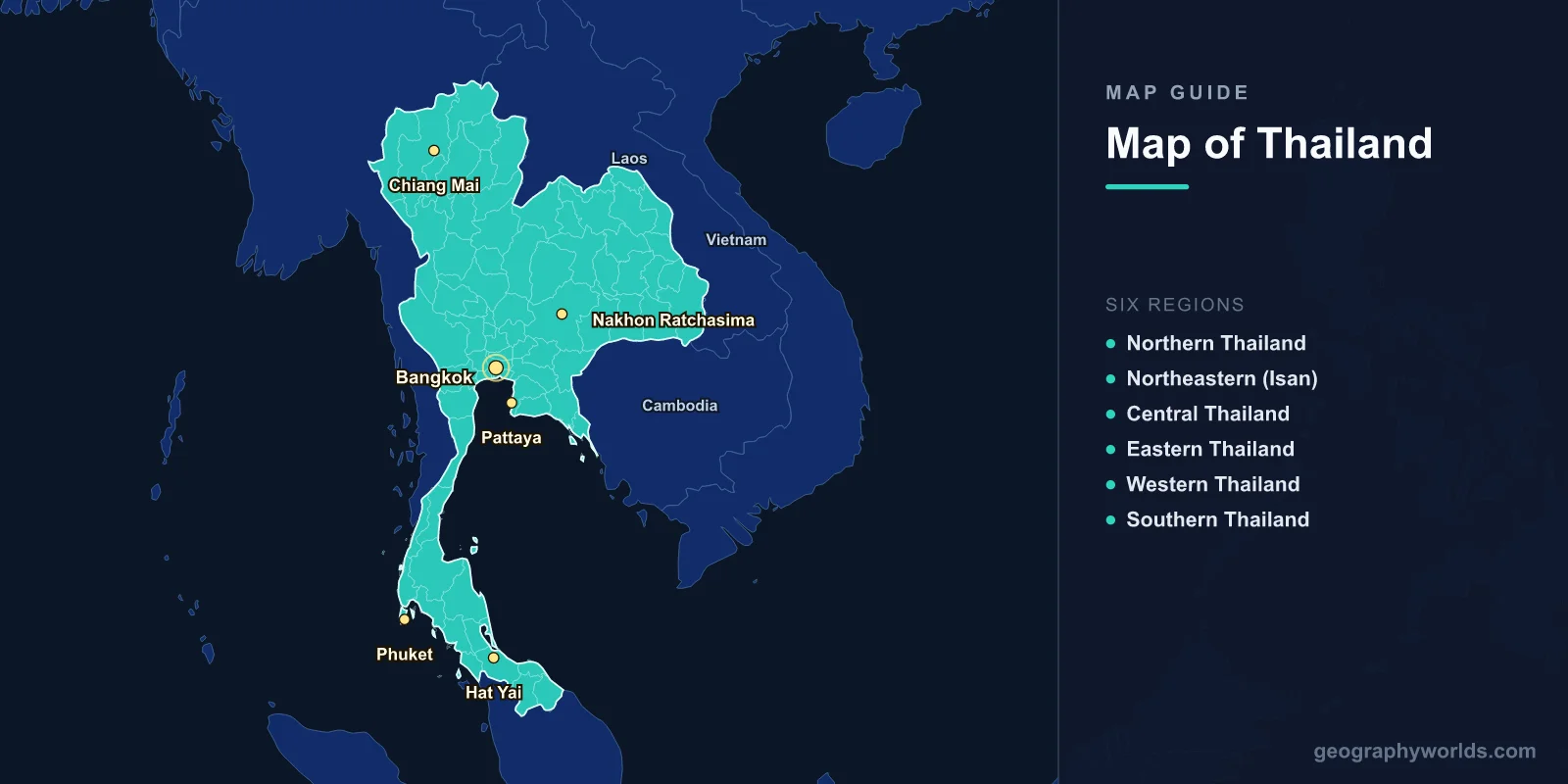
Thailand is located in Southeast Asia, covering 513,120 km2 (198,117 sq mi) with a population of approximately 71.8 million. The capital is Bangkok (13.7563°N, 100.5018°E). A map of Thailand shows 76 provinces grouped into six geographic regions, with the country shaped roughly like an axe head with a long handle extending southward along the Malay Peninsula.
Introduction
Thailand is bordered by Myanmar to the west and northwest, Laos to the northeast and east, Cambodia to the southeast, and Malaysia to the south. Its coastlines stretch along the Andaman Sea (western) and the Gulf of Thailand (eastern), totaling about 3,219 km. The country’s geography ranges from mountainous northern highlands to the flat Chao Phraya River delta and the tropical islands of the south.

Geographic Overview
- Area: 513,120 km2 (198,117 sq mi)
- Population: 71.8 million (2024)
- Capital: Bangkok
- Coordinates: 15.8700°N, 100.9925°E
- Highest Point: Doi Inthanon, 2,565 m
- Coastline: 3,219 km
Thailand’s terrain varies dramatically from north to south. The north features mountain ranges reaching 2,565 m at Doi Inthanon. The northeast (Isan) is a large, flat plateau called the Khorat Plateau, bordered by the Mekong River. Central Thailand is dominated by the fertile Chao Phraya River floodplain. Southern Thailand narrows to a peninsula shared with Myanmar, flanked by the Andaman Sea and Gulf of Thailand.
Major Regions
- Northern Thailand: Chiang Mai; mountains; hill tribes; teak forests
- Northeastern (Isan): Khorat Plateau; Mekong River border; Khon Kaen
- Central Thailand: Bangkok; Chao Phraya delta; rice basket of the nation
- Eastern Thailand: Pattaya; industrial zone; Rayong; Gulf coast
- Western Thailand: Kanchanaburi; mountains; River Kwai; Myanmar border
- Southern Thailand: Phuket, Ko Samui; Andaman coast; rubber plantations; islands
Thailand’s six regions reflect distinct topographies and cultures. The north is mountainous and culturally influenced by neighboring Myanmar and Laos. Isan, the largest and most populous region, is culturally linked to Laos, with many residents speaking Isan (a Lao dialect). The south has a significant Malay Muslim population, particularly in the provinces bordering Malaysia.
Major Cities
- Bangkok: 10.7 million (metro); capital; Chao Phraya River; economic center
- Chiang Mai: 1.2 million (metro); northern cultural capital; surrounded by mountains
- Pattaya: 1.2 million (metro); Gulf coast resort city; eastern seaboard
- Nakhon Ratchasima (Korat): 450,000; gateway to Isan; northeastern hub
- Phuket: 400,000; Andaman Sea island; Thailand’s largest island
- Hat Yai: 800,000 (metro); southern commercial center; near Malaysian border
Bangkok is one of Asia’s most primate cities, dominating Thailand’s economy, politics, and culture. It sits just 1.5 m above sea level on the Chao Phraya delta, making it one of the world’s most flood-vulnerable capitals. Chiang Mai, at 300 m elevation in a mountain valley, serves as the cultural capital of northern Thailand and a base for trekking in the surrounding highlands.
Bodies of Water & Natural Features
- Chao Phraya: 372 km; Thailand’s principal river; drains the central plain
- Mekong: Forms ~850 km of the border with Laos
- Gulf of Thailand: 320,000 km2; shallow tropical gulf; islands and coral reefs
- Andaman Sea: Western coast; limestone karsts; Similan Islands
- Doi Inthanon: 2,565 m; highest point; cloud forest; Chiang Mai Province
- Khao Sok National Park: Oldest evergreen rainforest in the world; Surat Thani Province
The Chao Phraya River system drains about one-third of Thailand’s land area and supports the country’s most productive rice-growing region. The Mekong River forms most of Thailand’s border with Laos and is vital for fisheries and irrigation. Thailand’s Andaman Sea coastline features dramatic limestone karst formations, including Phang Nga Bay’s famous sea stacks. The Gulf of Thailand contains popular island destinations including Ko Samui, Ko Pha Ngan, and Ko Tao.
Bordering Countries
- Myanmar: 2,416 km; longest border; western and northwestern
- Laos: 1,845 km; Mekong River border; northeast
- Cambodia: 817 km; southeastern border; near Angkor region
- Malaysia: 647 km; southern border; Malay Peninsula
Thailand is the only Southeast Asian country never colonized by a European power, partly due to its strategic position as a buffer between British Burma and French Indochina. Its borders with Laos follow the Mekong River for hundreds of kilometers. The Strait of Malacca, one of the world’s busiest shipping lanes, passes just south of Thailand’s coast.
Key Facts
- Thailand is roughly the size of France at 513,120 km2.
- The Chao Phraya delta produces about 60% of Thailand’s rice crop.
- Thailand has over 1,400 islands, most along the Andaman and Gulf coasts.
- The Mekong River forms 850 km of Thailand’s border with Laos.
- Bangkok is built on soft clay and sinking at a rate of 1–2 cm per year.
Fun Facts
- Thailand’s name means "Land of the Free"—it is the only Southeast Asian country never colonized by a European power.
- Doi Inthanon, the highest peak, was named after the last king of Chiang Mai.
- Phang Nga Bay’s "James Bond Island" became famous from the 1974 film The Man with the Golden Gun.
- Thailand is the world’s largest exporter of rice and rubber.
Final Thoughts
Thailand’s map reveals a geographically diverse country spanning from misty mountain ranges in the north to tropical islands in the south. Its position at the heart of mainland Southeast Asia, with four land borders and two coastlines, makes it a geographic crossroads. Understanding Thailand’s 76 provinces, major rivers, and coastal features is essential for anyone exploring Southeast Asian geography.
Test Your Geography Knowledge!
Think you know your maps? Try our interactive geography games!
Play Geography Games →