
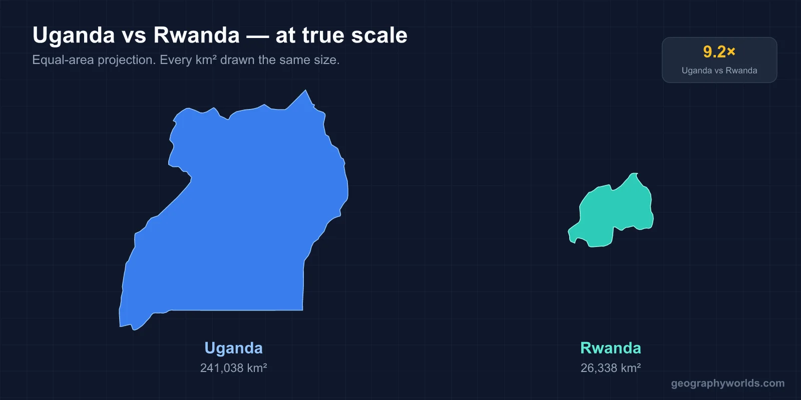
Uganda is about nine times the size of Rwanda and has roughly three times as many people. It covers 241,038 km² to Rwanda’s 26,338 km², and its 2024 census counted 45.9 million people against Rwanda’s estimated 14.4 million in 2026. In income the two are close. The IMF puts Uganda slightly ahead in nominal GDP per person, about $1,340 (2025) against $1,200 (2026), while Rwanda leads at purchasing-power parity, about $4,500 (2026) against $3,900 (2025). Uganda’s capital is Kampala, and its official languages are English and Swahili, with Luganda widely spoken. Rwanda’s capital is Kigali; its national language is Kinyarwanda, with English, French and Swahili also official. For a visitor, the real difference is scale. Uganda is a country of big lakes, a great river and long drives. Rwanda is a compact, crowded upland you can cross in a day.
Crossing Between Katuna and Gatuna
Many overland travellers meet the two countries at the same place: the border post of Katuna on the Ugandan side and Gatuna on the Rwandan side. Gatuna, about 80 km by road north of Kigali, is Rwanda’s busiest crossing and is open 24 hours a day. Because Rwanda is landlocked and most of its sea trade reaches it through Uganda, the lorries queueing there carry much of what Rwanda imports and exports.
Coming south from Kampala, the change is visible almost at once. Uganda sits at an average of about 900 m above sea level, on a plateau of swamps, farmland and lakes. Rwanda is high everywhere: its lowest point, on the Rusizi River in the far south-west, is 950 m. The country is sometimes called the “land of a thousand hills” (pays des mille collines). The roads bend constantly around valleys and ridges rather than running straight across open country.
Lake Victoria, the Nile and Murchison Falls
Uganda’s landscapes are built around water, which covers more than 15 per cent of the country. Much of the south lies on Lake Victoria, the world’s second-largest freshwater lake, shared with Kenya and Tanzania, and Kampala and Entebbe both stand near its shore. About 81 km east of Kampala, the city of Jinja sits where the White Nile leaves the lake. John Hanning Speke was the first European to see the source. The Owen Falls Dam, built in 1954, flooded the Ripon Falls that he described.
From there the Victoria Nile runs through Lake Kyoga, which is surrounded by marshes, and on to Lake Albert on the Congolese border. Just before Lake Albert it forces through a gap in the rock only 7 m wide and drops 43 m at Murchison Falls. Samuel and Florence Baker were the first Europeans to report the falls and named them after Roderick Murchison of the Royal Geographical Society. Ernest Hemingway crash-landed a plane just downriver in 1954. The falls give their name to the surrounding Murchison Falls National Park.

Uganda also has high mountains at both ends. On the western border, the Rwenzori range culminates in Mount Stanley at 5,109 m, the highest peak in both Uganda and the Democratic Republic of the Congo. On the Kenyan border in the east, the old volcano of Mount Elgon reaches 4,321 m at Wagagai. Uganda has ten national parks in total, including Kidepo Valley in the far north-east, Queen Elizabeth and Kibale in the west, as well as Semuliki.
Rwanda’s Thousand Hills, Lake Kivu and the Virungas
Rwanda packs its variety into a much smaller space. The watershed between the Nile and the Congo runs north to south through the country, and about 80 per cent of its land drains towards the Nile. The Nyabarongo, whose source in Nyungwe Forest is one candidate for the most distant source of the Nile, eventually reaches Lake Victoria through the Kagera. The rest drains into the Congo basin through Lake Kivu and the Rusizi River.
Lake Kivu is Rwanda’s largest lake and its western shoreline. It covers roughly 2,700 km² along the border with the Democratic Republic of the Congo. The lake has an unusual hazard: it is one of only three lakes in the world known to undergo limnic eruptions, releases of dissolved carbon dioxide, and its deep water also holds methane.

In the north-west rise the Virunga volcanoes, with Mount Karisimbi at 4,507 m, Rwanda’s highest point. In the south-west Nyungwe Forest shelters 13 species of primates, including chimpanzees. In the east, the savanna of Akagera National Park is a different country again. Lions were wiped out there after 1994 and were reintroduced from South Africa in 2015; black rhinos followed from South Africa in 2017, with more from European zoos in 2019. Our guide to Rwanda’s geography covers these regions in more detail.
Mountain Gorillas in Bwindi and Volcanoes National Park
Both countries sell the same headline experience, a trek to see mountain gorillas, and they share the population across the Virunga and Bwindi forests. Uganda’s Bwindi Impenetrable National Park, a World Heritage Site of 321 km² on the Congolese border, can only be explored on foot. It shelters about 400 gorillas, roughly half of all mountain gorillas, along with 350 bird species and around 120 mammals. Uganda’s smaller Mgahinga Gorilla National Park, on the Virunga slopes, adds gorillas and golden monkeys.
Across the border, Rwanda’s Volcanoes National Park covers 160 km² of five Virunga volcanoes: Karisimbi, Bisoke, Muhabura, Gahinga and Sabyinyo. It began in 1925 as the first national park created in Africa, and the American primatologist Dian Fossey arrived in 1967 and set up the Karisoke Research Centre there. The park holds an estimated third of the world’s mountain gorillas. Tourism is now Rwanda’s leading source of foreign exchange.
Two Rainy Seasons in Kampala and Kigali
Both countries lie close to the equator and have two wet seasons, but altitude sets the temperature. In most of Uganda the rains fall from March to May and September to November. January–February and June–August are dry, and heavy rain can make rural roads hard going. The far north has a single rainy season, from March to November. Average temperatures run from 25 to 29 °C, with December to February the hottest months. Kampala has no truly dry month; April is its wettest, with around 169 mm.
Kigali, at 1,567 m, is cooler, with daily temperatures between about 15 and 27 °C all year. Its rains come from February to June and from September to December. The long dry season from June to September, when it often does not rain at all, is the driest time of year. April is the wettest month, with about 154 mm, and the mountainous west and north are generally cooler than the lower-lying east.
Kampala’s Hills and Kigali’s Umuganda Saturdays
Kampala began on Old Kampala hill, where Fort Lugard stood, and grew from its original seven hills over many more. The city proper had 1,797,722 people in the 2024 census, while estimates for its metropolitan area range from about 4 million to 6.7 million (2019). It sits in the heart of Buganda, the kingdom that gave Uganda its name, and five traditional kingdoms still have cultural roles. For more on the city, see our guide to Kampala.
Kigali was founded in 1907 as a German administrative outpost and became the capital only at independence in 1962. It had 1,745,555 people in August 2022, about seven times as many as Gisenyi, the next-largest city. Visitors notice the order. Plastic bags have been banned since 2008, and on the last Saturday of each month the whole country stops from 8 to 11 am for umuganda, compulsory community work for adults aged 18 to 65, when most services close and public transport is limited. The city is profiled in our guide to Kigali. The city’s modern history is shaped by the 1994 genocide against the Tutsi, which the Rwandan Patriotic Front ended with its military victory in July of that year. Its leader, Paul Kagame, has been president since 2000. Uganda’s president, Yoweri Museveni, has held power since 1986.
Matooke, Rolex, Isombe and Brochettes
Food is where the neighbours overlap most. In central Uganda the starch of a meal is usually matooke, steamed and mashed green banana, or posho, a firm maize-meal porridge, served with a stew of groundnuts, beans or meat; in the north, east and west it is more often kalo, made from millet. The snack every visitor meets is the rolex, an omelette with vegetables rolled in a chapati. It started with a chapati seller in the Busoga region and spread through Wandegeya, beside Makerere University, where students wanted a cheap, quick meal.
In Rwanda bananas also fill more than a third of the farmland. Ugali, called ubugari locally, is a common staple, and isombe, mashed cassava leaves, is served with fish, rice or potatoes. Evenings out mean brochettes, usually goat on skewers, served with grilled bananas, washed down with ikigage sorghum beer or urwagwa banana beer. Language shifts with the menu. In Uganda, English is the official language and Luganda the most widely heard language around Kampala. In Rwanda, Kinyarwanda is the language of native Rwandans and French was long the second language, but under the RPF government the country has sought closer ties with the East African Community and the English-speaking world, and it is one of the few Commonwealth members with no historical link to the British Empire.