

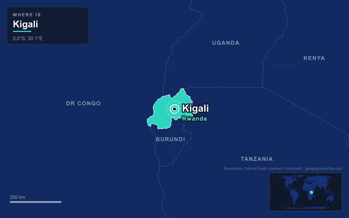
Ridges, valleys and marsh: that is the ground Kigali, the capital and largest city of Rwanda, is built on. The city sits near the country’s geographical centre at an average elevation of about 1,567 metres, spread over a tangle of hills whose valley floors drop to around 1,300 metres. The 2022 census counted 1,745,555 residents, roughly seven times the population of the second-largest city, Gisenyi. Kigali is also one of the country’s five top-level administrative units, a province in its own right. Almost everything about the capital, from where it began in 1907 to where its buses depart and where it can still grow, follows from that folded terrain.

Nyarugenge Hill and Richard Kandt’s Choice in 1907
The city takes its name from a mountain. In Kinyarwanda the prefix ki- joined to -gali, meaning wide or broad, was first applied to Mount Kigali, a broad summit of 1,853 metres on the western side of today’s city. Rwandan oral tradition, collected by the scholar Alexis Kagame, ties the name to King Cyilima I Rugwe, who is said to have looked out over the land he had conquered and declared it vast. The kingdom itself, according to the same traditions, was founded in the 14th century on the shores of Lake Muhazi, about 40 kilometres east, and its later kings ruled from Nyanza in the south. Kigali was not their capital.
The town began with a hilltop decision. Rwanda and Burundi had been assigned to Germany as part of German East Africa, and in 1907, when Berlin separated their administrations, the explorer Richard Kandt was appointed Rwanda’s first resident. He placed his headquarters on Nyarugenge Hill, citing its central position in the country, its wide views and the security of high ground. His house, the first European-style house in Kigali, still stands close to the central business district as the Kandt House Museum of Natural History. From 1908 Kandt let foreign traders in, and Greek and Indian merchants opened Kigali’s first shops, dealing in cloth and beads. There were still only around 30 firms in the town by 1914.

Nyarugenge remains the core. The central business district, still called mu mujyi (“in town”), crowns the hill with the 20-storey Kigali City Tower, the national bank, the finance ministry and hotels such as the Hôtel des Mille Collines. Oddly for a city centre, it sits near the western edge of the built-up area. The steep flanks of Mount Kigali blocked growth to the west, so the city spread east across gentler ridges instead. On the south-western shoulder of the same hill is Nyamirambo, laid out by the Belgian administration in the 1920s for civil servants and Swahili traders. Its Green Mosque, dating from the 1930s, is the oldest in Kigali, and the district is still known as the Muslim Quarter. That early community left a lasting mark: in the 2012 census 5.7 per cent of Kigali residents were Muslim, against 2.0 per cent nationally.
The Nyabugogo Valley Between Mount Kigali and Mount Jali
Below Nyarugenge to the north lies the city’s lowest ground. The Nyabugogo River, the largest to run through Kigali, flows south out of Lake Muhazi, then turns west through the gap between Mount Kigali and Mount Jali, whose summit reaches 2,071 metres. It drains almost the whole city before joining the Nyabarongo, part of the upper headwaters of the Nile. The Nyabarongo itself traces the western and southern edge of the city’s administrative area, well outside the built-up zone.
Because every road out of the hills has to come down to the valley floor, Nyabugogo became the transport hub. The city’s main bus and shared-taxi station is here, with departures to towns across Rwanda and to neighbouring countries. That matters in a city where only six per cent of households owned a car in 2011; most people travel by bus or by motorcycle taxi, with more than 10,000 moto drivers registered with cooperatives in 2012. The valley floors are also wetlands, which store water and absorb floods but are under pressure from farming and building. One restored marsh, Umusambi Village, now shelters vulnerable grey crowned cranes.

Eastward Ridges From Kiyovu to Kanombe
East of the centre the city climbs over one ridge after another. Kiyovu, on the eastern slopes of Nyarugenge, has held large houses since colonial times, and the president’s residence is there. Its lower part filled with informal housing after independence until the government expropriated it in 2008, compensating residents or moving them to a purpose-built estate at Batsinda. Beyond it come Kacyiru, with most ministries and the office of the president; Kimihurura; Nyarutarama, home to Rwanda’s only golf course; and Gisozi, site of the Kigali Genocide Memorial, where the remains of more than 250,000 people are buried. Remera holds the 45,000-seat Amahoro Stadium and the neighbouring indoor arena, and Kanombe, about 10 kilometres from the centre, has Kigali International Airport. On the KN5 highway, about 6 kilometres west of the airport, stands the domed Kigali Convention Centre, which hosted an extraordinary African Union summit in 2018 and the Commonwealth Heads of Government Meeting in June 2022.
The administrative map follows the same geography. Since 2006 the city has had three districts: Nyarugenge in the south-west, Kicukiro in the south-east and Gasabo, which takes up the entire northern half. Reforms in January 2020 moved much of their power to a single city council. Only about 70 per cent of the area inside the boundary is built up; the rest includes steep hillside, small farms and valley marshes.
A Climate Set by 1,567 Metres of Altitude
Kigali lies just under two degrees south of the Equator, yet its height keeps it mild. Daily temperatures run between about 15 °C and 27 °C with little change through the year, and the climate is classed as tropical savanna. Rain comes in two seasons, from February to June and from September to December, separated by a long dry season from June to September and a shorter one around January. April is the wettest month, averaging about 154 millimetres. A report by the Strategic Foresight Group found that climate change has cut the number of rainy days while making torrential downpours more frequent, and it counts Rwanda among the fast-warming countries, with average temperatures up by 0.7 to 0.9 °C over the 50 years to 2013.
From 6,000 People in 1962 to 1.7 Million in 2022
For most of the colonial period the hills stayed quiet. Belgian troops took Kigali on 6 May 1916, and under the League of Nations mandate of Ruanda-Urundi the real capital was Usumbura, now Bujumbura, across the border in Burundi. When Rwanda became independent in 1962, Kigali had only about 6,000 inhabitants. Nyanza, the royal seat, and Butare, the intellectual and religious centre then known as Astrida, were both considered as capitals, but Kigali won because it was central. Even in the early 1970s it had about 25,000 people and five paved roads. It was still a small administrative town on 5 July 1973, when defence minister Juvénal Habyarimana overthrew President Grégoire Kayibanda: officers who had gathered in the capital for an Independence Day military tattoo moved on the government buildings, and Kayibanda was placed under house arrest. The coup was bloodless, and by 11 July the troops had left the streets.
Growth came once rules restricting migration to the city eased: 115,000 by 1978 and 235,000 by 1991. Then came catastrophe. On the evening of 6 April 1994 President Juvénal Habyarimana’s plane was shot down near Kigali’s airport, and in the genocide that followed between 500,000 and 800,000 Tutsi and moderate Hutu were killed. The Rwandan Patriotic Front fought its way into the city and took it on 4 July 1994, now marked as Liberation Day. The capital lost much of its population to killing and flight, but returning refugees, high birth rates and rural migrants refilled it quickly. It passed 600,000 by 2002 and reached 1.13 million in 2012, partly because the boundary was enlarged. The newcomers made it a young city: at the 2012 census 73 per cent of residents were under 30, and men slightly outnumbered women, as working-age migrants arrived from the countryside while their families often stayed on the farm. The capital also dominates the formal economy. A 2015 World Bank study found that 92 per cent of the turnover reported by registered companies came from firms in the city of Kigali.
That growth has pushed building ever higher up the slopes and deeper into the valleys. A masterplan adopted in 2013 aims to make Kigali a decentralised modern city by 2040, but clearing informal housing to achieve it has drawn criticism from Human Rights Watch and others. On the last Saturday of each month, adults aged 18 to 65 join umuganda, three hours of compulsory community work from 8 to 11 am, much of it cleaning streets, part of the reason Kigali is often called one of Africa’s cleanest cities.
The land that shaped Kigali shapes the whole country, as our guide to Rwanda’s geography explains, from volcanoes in the north-west to lakes in the east. For the four countries on its borders, see the countries that border Rwanda, and for a fuller portrait of the nation beyond its capital, turn to our Rwanda country guide.
Quick Facts About Kigali
- Country: Rwanda
- Continent: Africa (East Africa)
- Country population: approximately 14.9 million
- Capital city status: Kigali is the capital of Rwanda, the seat of national government, and the location of foreign embassies, parliament, and the head of state's official residence.
Frequently Asked Questions
What is the capital of Rwanda?
The capital of Rwanda is Kigali. Kigali is the seat of national government, hosts most foreign embassies and consulates, and is typically where the head of state and parliament are located.
What continent is Kigali in?
Kigali, the capital of Rwanda, is located in Africa, in the East Africa region. As Rwanda's capital, Kigali serves as the country's primary connection to the broader African political, economic, and cultural sphere.
Why is Kigali the capital of Rwanda?
Kigali was chosen as the capital of Rwanda for reasons that typically combine geography, history, and politics. Capital city selections often reflect a desire for centrality (being accessible from across the country), historical importance (being a longstanding seat of government or culture), or neutrality (being acceptable to multiple regions or ethnic groups within the country). The specific reasons for Kigali's designation are detailed in the city's history above.
What is Kigali known for?
As the capital of Rwanda, Kigali is best known for housing the country's central government institutions — parliament, presidential or royal residences, supreme court, and key ministries. It is also typically a major cultural and economic center within Rwanda, hosting national museums, embassies, and signature monuments. The introduction and history sections above provide detailed coverage of the city's specific notable institutions and landmarks.
Related Pages
- Rwanda Country Guide — full geography, climate, economy, and culture overview
- Flag of Rwanda — meaning, history, and design of Rwanda's national flag