
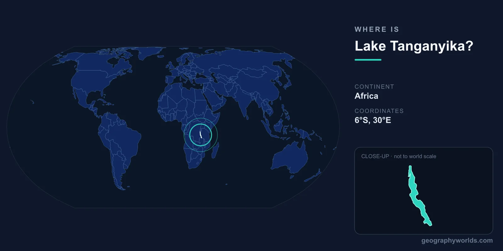
Lake Tanganyika is located in the western branch of the East African Rift, centered at approximately 6°S latitude and 30°E longitude. It stretches 673 kilometers from Burundi in the north to Zambia in the south, making it the world's longest freshwater lake. It is shared by four countries: Tanzania, DR Congo, Burundi, and Zambia.
Introduction
At 1,470 meters deep, Tanganyika is Africa's deepest lake and the world's second-deepest after Lake Baikal. It holds approximately 18,900 cubic kilometers of water — about 16 percent of the world's available surface freshwater — and is estimated to be roughly 9-12 million years old.

Exact Location & Coordinates
- Center Coordinates: 6°S, 30°E
- Region: East Africa, western Rift Valley
- Extent: 673 km long, up to 72 km wide
- Elevation: 773 m above sea level
On a world map, Lake Tanganyika is the long, narrow lake in central-eastern Africa, running roughly north to south along the Congo-Tanzania border. It is the second of the great African Rift Valley lakes (after Lake Albert in the north), sitting in a deep graben formed by the rifting apart of the African continent.
To find Lake Tanganyika on a map, locate Tanzania and then look at its western border with the Democratic Republic of the Congo — the lake forms much of this border. Its distinctive elongated shape, similar to Lake Baikal, makes it identifiable even on small-scale world maps.
Surrounding Countries & Borders
- Tanzania: Eastern shore (~41% of lake)
- DR Congo: Western shore (~45% of lake)
- Burundi: Northern shore
- Zambia: Southern tip
The Democratic Republic of the Congo has the largest share of Lake Tanganyika along the western shore. Tanzania controls the eastern shore, including the port town of Kigoma, which was the endpoint of Henry Morton Stanley's famous meeting with David Livingstone in 1871. Burundi's capital Bujumbura (now Gitega is the political capital) lies on the lake's northern shore.
Zambia has only a small portion of the lake's southern tip but it includes the city of Mpulungu, an important fishing port. The lake's shores are generally steep and mountainous, with the rift valley walls rising dramatically on both sides, particularly on the Congo side.
Geographic Context
- Part Of: East African Rift System (western branch)
- Outlet: Lukuga River (flows west to Congo River system)
- Inflow: Ruzizi River from Lake Kivu, plus many smaller rivers
Lake Tanganyika occupies a deep graben in the western (Albertine) branch of the East African Rift. The rift valley walls rise steeply from the lake, sometimes reaching 2,000 meters above the water surface. This dramatic topography creates a landscape of plunging escarpments and narrow coastal plains.
The lake's only outlet is the Lukuga River, which flows westward to eventually join the Congo River system. The Ruzizi River brings water from Lake Kivu to the north. Like Lake Baikal, Tanganyika's great depth and age have allowed remarkable speciation to occur within its waters.
Physical Characteristics
- Maximum Depth: 1,470 m (Africa's deepest lake)
- Length: 673 km (world's longest freshwater lake)
- Volume: 18,900 km³ (~16% of world's surface freshwater)
- Age: ~9-12 million years
Lake Tanganyika's extreme depth means that below about 200 meters, the water is ancient, undisturbed, and devoid of oxygen. This deep anoxic water has been undisturbed for thousands of years. Only the top layer supports aquatic life, but this surface layer is remarkably productive and biodiverse.
The lake's water is warm at the surface (25-28°C) but cold at depth. Its great thermal mass moderates the climate around its shores, creating relatively humid conditions compared to the surrounding area. The lake rarely cools enough for complete mixing, making it permanently stratified (meromictic).
Why It Matters
- Biodiversity: Extraordinary endemism — 98% of cichlids found nowhere else
- Fisheries: Critical food source for ~10 million people
- Science: Model system for studying evolution and speciation
Lake Tanganyika is one of the world's most important sites for studying evolution. It contains over 350 species of cichlid fish, with approximately 98 percent found nowhere else on Earth. These cichlids have diversified through adaptive radiation, evolving to fill a wide range of ecological niches — much like Darwin's finches but on a far grander scale.
The lake supports fisheries that provide critical protein for roughly 10 million people in the four surrounding countries. The dagaa (Stolothrissa tanganicae), a small sardine-like fish, is the most commercially important species. Climate change is warming the lake and reducing its mixing, which threatens to decrease fish productivity in coming decades.
Key Facts
- Lake Tanganyika is centered at approximately 6°S, 30°E in East Africa's Rift Valley.
- At 673 km long, it is the world's longest freshwater lake.
- At 1,470 m deep, it is Africa's deepest and the world's second-deepest lake.
- Four countries border it: Tanzania, DR Congo, Burundi, and Zambia.
- ~98% of its 350+ cichlid fish species are found nowhere else on Earth.
Fun Facts
- Lake Tanganyika is estimated to be 9-12 million years old — one of the oldest lakes on Earth.
- Henry Morton Stanley met David Livingstone near Tanganyika's shore in 1871, uttering "Dr. Livingstone, I presume."
- The lake's deep water has been undisturbed for thousands of years, creating a natural time capsule.
- Tanganyika's cichlid diversity rivals the famous cichlids of Lake Malawi as a model for evolution research.
Final Thoughts
Lake Tanganyika stretches through East Africa's western Rift Valley at approximately 6°S, 30°E, a 673-kilometer body of water shared by four nations. As the world's longest and Africa's deepest freshwater lake, it holds extraordinary evolutionary significance with its hundreds of endemic species. Its combination of extreme depth, ancient age, and unmatched biodiversity makes it one of the most remarkable natural features on the world map.
Test Your Knowledge!
Think you know where things are on the map? Test your skills!
Play Geography Games →