
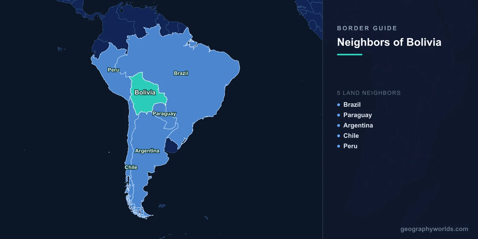
Bolivia shares land borders with five countries: Brazil to the north and east, Paraguay to the southeast, Argentina to the south, Chile to the southwest, and Peru to the northwest. Bolivia is one of only two landlocked countries in South America, the other being Paraguay.
Introduction
Bolivia's borders traverse some of South America's most extreme geography. From the Amazon lowlands in the north to the soaring Altiplano and Andes in the west, and the dry Chaco scrubland in the south, Bolivia's borders cross three distinct ecological zones. The country lost its Pacific coastline to Chile in the War of the Pacific (1879-1884), and the quest for sea access remains a central theme in Bolivian national identity and foreign policy.

Overview of Bolivia's Borders
- Total Land Borders: 7,252 km
- Number of Neighbors: 5 countries
- Longest Border: Brazil (3,403 km)
- Shortest Border: Chile (942 km)
- Landlocked: Yes, since 1884
Bolivia's borders reflect its position at the geographic heart of South America. The country sits between the Andes and the Amazon, with borders that range from tropical lowlands below 200 meters elevation to Andean peaks above 6,000 meters. Brazil dominates the northern and eastern boundary, while the shorter western borders with Chile and Peru cross the high Altiplano.
Bolivia has lost significant territory through wars and treaties since independence in 1825. The most consequential was the loss of the Atacama coast to Chile, but Bolivia also ceded the Acre region to Brazil in 1903 and lost territory to Paraguay in the Chaco War of 1932-1935. These territorial losses have profoundly shaped Bolivian identity and its relationships with neighbors.
Northern and Eastern Neighbor: Brazil
- Border Length: 3,403 km
- Key Features: Amazon Basin, Pantanal wetlands, Guapore River
- Border Cities: Cobija-Brasileia, Corumba-Puerto Quijarro
- Historical Context: Acre territory ceded to Brazil in 1903
The Brazilian border is Bolivia's longest at 3,403 km, stretching from the Amazon rainforest in the north through tropical lowlands to the Pantanal wetlands in the east. Major rivers including the Guapore (Itenez), Mamore, and Madeira form significant portions of this boundary. The border passes through some of the most biodiverse terrain on Earth, including portions of the Pantanal, the world's largest tropical wetland.
The border was largely established by the Treaty of Petropolis in 1903, after Brazil effectively purchased the Acre territory following a conflict over rubber-rich lands. Today, cross-border trade is growing, with the main crossing points at Cobija-Brasileia in the north and Corumba-Puerto Quijarro in the east. Brazil is Bolivia's most important neighbor economically, particularly as a buyer of Bolivian natural gas through a major pipeline.
Southern Neighbors: Paraguay and Argentina
- Paraguay Border: 753 km
- Argentina Border: 942 km
- Key Features: Gran Chaco, Pilcomayo River, Andean foothills
- Historical Context: Chaco War with Paraguay (1932-1935)
The Paraguayan border runs 753 km through the Gran Chaco, a vast semi-arid wilderness of dry forests and scrubland. This border was established after the devastating Chaco War (1932-1935), the bloodiest South American conflict of the 20th century, in which roughly 100,000 soldiers died. Paraguay gained most of the disputed Chaco territory, though Bolivia retained the foothills where oil deposits were later found.
Argentina's 942 km border runs from the Chaco lowlands in the east to the Andean highlands in the west. The Pilcomayo River forms part of this boundary, flowing through the Chaco before joining the Paraguay River. The main crossing point is at Villazon-La Quiaca in the western highlands, an important route for trade and migration between the two countries. Many Bolivian workers migrate seasonally to Argentina for agricultural work.
Western Neighbors: Chile and Peru
- Chile Border: 942 km
- Peru Border: 1,075 km
- Key Features: Altiplano, Lake Titicaca, Salar de Uyuni, volcanoes
- Elevation: Much of both borders above 3,500 m
The Chilean border runs 942 km across the high Altiplano, a vast plateau averaging over 3,700 meters in elevation. This border crosses a landscape of salt flats, volcanic peaks, high-altitude lagoons, and geysers. The Salar de Uyuni, the world's largest salt flat at over 10,000 square kilometers, lies near the Chilean border and contains the world's largest lithium reserves, a resource of growing strategic importance.
The Peruvian border at 1,075 km crosses the Altiplano and the shores of Lake Titicaca, the world's highest navigable lake at 3,812 meters. The lake is sacred in Andean culture and was central to the Inca creation myth. The border cities of Desaguadero (on both sides) and Copacabana-Yunguyo are busy crossing points. Bolivia and Peru share deep cultural ties through their Aymara and Quechua populations, who predate the modern border by thousands of years.
Cross-Border Relations and the Sea Access Issue
- Sea Access Lost: 1884 (War of the Pacific)
- Transit Rights: Through Chilean ports of Arica and Antofagasta
- ICJ Ruling: 2018 - Chile not obligated to negotiate
- Andean Community: Member with Peru, Colombia, Ecuador
Bolivia's loss of its Pacific coastline in the War of the Pacific defines its foreign policy to this day. The Bolivian constitution enshrines the right to sovereign sea access, and "Day of the Sea" is observed annually on March 23. Bolivia took Chile to the International Court of Justice seeking an obligation to negotiate sea access, but the court ruled in 2018 that Chile was not legally required to do so. Chile grants Bolivia free transit rights through the port of Arica under the 1904 treaty.
Beyond the sea access issue, Bolivia maintains active diplomatic and economic relationships with all its neighbors. It is a member of the Andean Community and an associate member of Mercosur. Brazil is its most important economic partner, purchasing the majority of Bolivia's natural gas exports. Bolivia's central South American position and rich natural resources, including lithium, natural gas, and minerals, give it strategic importance despite its landlocked status.
Key Facts
- Bolivia borders 5 countries: Brazil, Paraguay, Argentina, Chile, and Peru.
- Bolivia's longest border is with Brazil at 3,403 km.
- Bolivia has been landlocked since losing its Pacific coast to Chile in 1884.
- Lake Titicaca on the Peru border is the world's highest navigable lake at 3,812 m.
- The Salar de Uyuni near the Chilean border is the world's largest salt flat and largest lithium reserve.
Fun Facts
- Bolivia observes "Day of the Sea" every March 23 to mourn the loss of its Pacific coastline.
- The Chaco War with Paraguay (1932-1935) was fought partly over rumors of oil in the Chaco region.
- Bolivia's Salar de Uyuni is so flat and reflective that it is used to calibrate satellite altimeters.
- Bolivia ceded the Acre territory to Brazil in 1903 after a conflict over rubber, receiving payment rather than territory in return.
Final Thoughts
Bolivia's five borders define a nation at the crossroads of South America, from the Amazon lowlands shared with Brazil to the towering Altiplano along Chile and Peru. As a landlocked country that has lost territory to three of its five neighbors, Bolivia's borders tell a story of geographic grandeur and historical loss, yet the country's central position and vast natural resources ensure it remains vital to the continent's future.
Test Your Knowledge!
Think you know which countries share borders? Try our geography games!
Play Geography Games →