
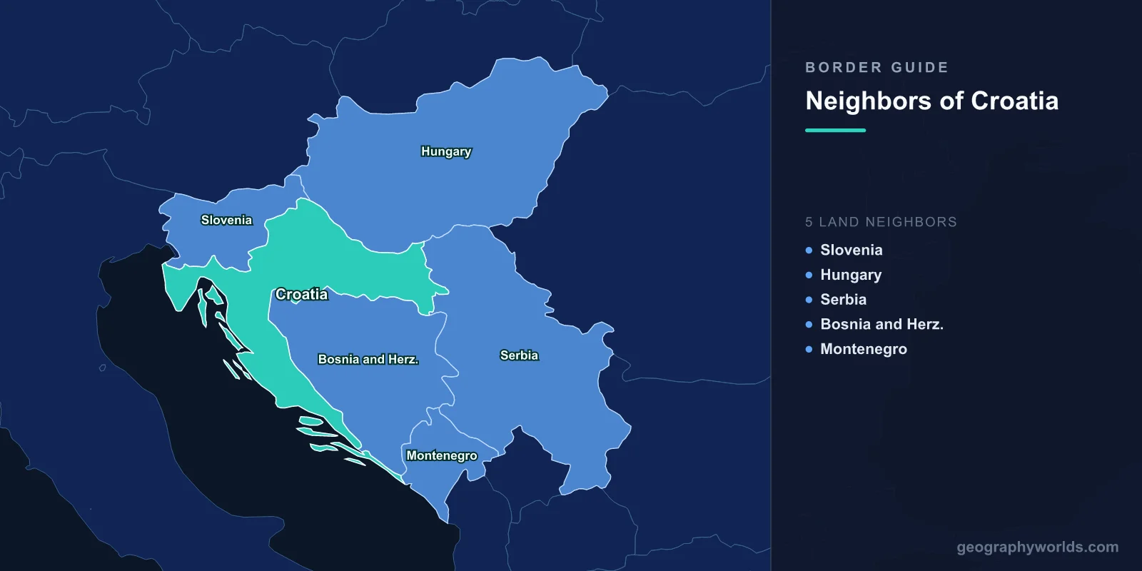
Croatia has five land neighbours: Slovenia, Hungary, Serbia, Bosnia and Herzegovina and Montenegro. Between them they account for 2,292 km of frontier wrapped around a country whose outline looks like something that snapped and was glued back at an angle — a thin coastal ribbon running roughly 500 km down the Adriatic, hinged near Zagreb to a fat inland lobe of farmland pointing east toward Belgrade.
The number is not what makes those borders interesting. What makes them interesting is that one of the five cuts straight through Croatia and out the other side.
Twenty Kilometres of Bosnian Coast, and Why They Are There
Somewhere between the villages of Klek and Neum, the Adriatic shoreline stops being Croatian for about twenty kilometres and belongs to Bosnia and Herzegovina instead. Everything south of that gap — the salt pans at Ston, the whole Pelješac peninsula, Dubrovnik, Cavtat, the Konavle valley down to the Montenegrin line — is physically detached from the rest of the country. Roughly 120,000 Croatian citizens live behind a foreign border from their own capital.
This is not a modern accident. It dates to 1699 and the Treaty of Karlowitz, which ended the Great Turkish War. The Republic of Ragusa, the independent merchant city we now call Dubrovnik, had spent centuries playing the Ottomans off against Venice. When the map was redrawn, Ragusa deliberately handed the Neum strip to the Ottoman Empire so that it would share a land border with a distant sultan rather than with the Venetian Republic creeping down the coast. The arrangement was reconfirmed at Passarowitz in 1718. A small state bought itself a buffer, and three hundred years later that piece of insurance is the reason a bus from Split to Dubrovnik used to face passport control twice in ninety minutes.
The Bridge Built to Avoid a Border
Croatia’s answer took twenty-five years of arguing and roughly €420 million. The Pelješac Bridge opened on 26 July 2022: a cable-stayed span 2,404 m long on six pylons, with the deck lifted 55 m above the water so that ships can still reach Neum’s own bay. It leaps from Komarna on the mainland to the neck of the Pelješac peninsula, where new roads and a bypass around Ston carry traffic on to the Dubrovnik highway.
European Union cohesion funds covered about 85 per cent of the cost, and the main contractor was China Road and Bridge Corporation — the first major EU-financed infrastructure project awarded to a Chinese state-owned builder, which caused a certain amount of comment in Brussels. The urgency was real. When Croatia joined the EU in 2013, the two Neum checkpoints became an external EU frontier, and the summer queues went from irritating to genuinely damaging for the Dubrovnik tourist economy. Since 2022 you can drive from Zagreb to Dubrovnik without leaving Croatian soil for the first time since the country existed.
One Thousand Kilometres of Bosnia
The Bosnian border is not just the awkward one, it is by far the longest: 1,011 km, roughly 44 per cent of Croatia’s entire land frontier, and a remarkable amount of boundary for a country of only 56,594 km². It follows the Una in the north-west, swings along the Sava through the Slavonian plain, then climbs into the bare limestone of the Dinaric karst behind the coast, where the line often runs along ridge crests with nothing on either side but scrub and sinkholes.
Nobody renegotiated it after the 1990s. When Yugoslavia dissolved, the Badinter Arbitration Committee advised in 1991 and 1992 that the internal boundaries between the republics should become international ones, applying the principle of uti possidetis juris. That decision froze administrative lines drawn for Yugoslav convenience into state borders, which is why the frontier ignores rivers, valleys and settlement patterns in roughly equal measure.
Traffic crosses at Stara Gradiška and Slavonski Brod on the Sava, at Maljevac in the north-west, at Vinjani Donji above Imotski, and at Nova Sela–Bijača on the motorway near Metković. Since 1 January 2023, when Croatia entered the Schengen area and adopted the euro on the same morning, all of these have been full external Schengen crossings with biometric checks. In the other direction, Bosnia depends on Croatia for the sea: the port of Ploče, at the mouth of the Neretva, handles most Bosnian maritime trade under a transit agreement, so the country with twenty kilometres of coastline gets its shipping done in someone else’s harbour.
A Bay Two Governments Still Cannot Divide
Croatia’s 600 km border with Slovenia looks tame by comparison, tracing the Sutla, the Mura and the Dragonja through hills and vineyards. The trouble is at the very end of it, in the water.
Slovenia has only about 47 km of coastline, and the Gulf of Piran — nineteen square kilometres of shallow water at the head of the Adriatic — is most of what it has. Without a share of it, Slovenian ships leaving Koper must pass through Croatian or Italian territorial waters to reach the high seas. Croatia argued for a median line down the middle of the bay. Slovenia argued that it had administered almost all of it before 1991 and needed a corridor out.
The two sides signed an arbitration agreement in Stockholm on 4 November 2009, which unblocked Croatia’s stalled EU accession talks. Then in July 2015 the media published intercepted phone calls between the Slovenian-appointed arbitrator, Jernej Sekolec, and Slovenia’s agent to the tribunal, Simona Drenik, discussing tactics. Croatia walked out. The tribunal reconstituted itself and ruled anyway on 29 June 2017, giving Slovenia roughly three quarters of the bay plus a “junction area” corridor to international waters. Croatia has never implemented the award, and in January 2020 the Court of Justice of the EU decided it had no jurisdiction to force the issue. Both countries are now inside Schengen, so nobody stops at Bregana any more — but the sea boundary still exists in two versions depending on whose map you are holding.
Where the Danube Refuses to Stay Put
The 314 km border with Serbia runs mostly down the Danube, and rivers make poor boundaries once engineers start straightening them. Croatia insists the line is the cadastral one: the river’s course as surveyed in the nineteenth century, before the meanders were cut off. Serbia insists it is the current thalweg, the middle of the navigable channel. The gap between the two readings covers something like 10,000 hectares of floodplain.
The oddity is that Serbia does not want everything the rival theory would give it. Croatia’s cadastral argument would hand Serbia several pockets on the west bank, but Belgrade declines them, because accepting the parcels would mean accepting the principle. That leaves a handful of west-bank scraps that neither state actively claims — most conspicuously Gornja Siga, about seven square kilometres of scrub and forest where a Czech libertarian activist, Vít Jedlička, planted a flag in April 2015 and declared the Free Republic of Liberland. Croatian police have detained would-be settlers there ever since, which is a fairly practical rebuttal of the claim that the land is ungoverned. The serious traffic passes further south at Bajakovo and Batrovci, the Zagreb–Belgrade motorway crossing and now an EU external border; the wider picture is set out in our guide to the countries that border Serbia.
Nineteen Kilometres, and a Peninsula the UN Had to Watch
The shortest of the five is the Montenegrin border, just 19 km of it, dropping from the Konavle hills to the sea. Almost all the difficulty concentrated on one three-kilometre spit of land: Prevlaka, which sits at the mouth of the Bay of Kotor and therefore controls the approach to the old Yugoslav naval anchorage at Tivat.
The Yugoslav People’s Army held it through the war. From February 1996 to December 2002 a small United Nations observer force, UNMOP, monitored a demilitarised zone there — one of the smallest peacekeeping mandates the organisation has ever run. It ended with a provisional agreement in December 2002 under which Prevlaka is Croatian, stays demilitarised, and Montenegro keeps guaranteed access to its own bay. A permanent maritime delimitation has still not been signed. The land crossing at Karašovići and Debeli Brijeg, meanwhile, produces some of the longest August queues anywhere on the Adriatic.
Hungary, and the Five Lines Compared
That leaves the quietest border of the set. The 348 km Croatia shares with Hungary follows the Drava and the Mura across flat, wet, heavily farmed country, and the main crossing at Goričan and Letenye carries the motorway between Zagreb and Budapest. Since Schengen accession there is nothing to stop for; a stretch of frontier that was strung with razor wire during the 2015 migration route now barely registers as you drive over it. Hungary’s other six neighbours are set out in our piece on the countries bordering Hungary.
| Neighbour | Length | What marks the line | Status since January 2023 |
|---|---|---|---|
| Bosnia and Herzegovina | 1,011 km | Una and Sava rivers, then Dinaric karst ridges | Schengen external border |
| Slovenia | 600 km | Sutla, Mura and Dragonja rivers | Schengen internal, no checks |
| Hungary | 348 km | Drava and Mura rivers | Schengen internal, no checks |
| Serbia | 314 km | The Danube, in two competing versions | Schengen external border |
| Montenegro | 19 km | Konavle hills down to Prevlaka | Schengen external border |
| Total | 2,292 km | — | — |
Read that list from top to bottom and you get a compressed history of three centuries in the region: an Ottoman buffer that hardened into a thousand-kilometre seam, two Habsburg river lines that have gone soft, a Danube that will not sit still, and nineteen kilometres that needed a UN mission to settle.
A country that had to build a 2.4 km bridge to reach a quarter of its own coastline is a country worth learning by its outline rather than its name — and Croatia’s bent, hollowed silhouette is one of the most frequently misidentified in our country shapes game.