
Saudi Arabia has seven land neighbours: Yemen, Iraq, Jordan, Oman, the United Arab Emirates, Kuwait and Qatar. Taking the length of each frontier as Wikipedia's border articles give it, the seven lines add up to about 4,272 km, with Yemen the longest at 1,307 km and Qatar the shortest at 87 km. Across the water the kingdom also faces Bahrain, joined to it by the 25 km King Fahd Causeway, Iran on the far side of the Persian Gulf, and Egypt, Sudan and Eritrea across the Red Sea. Nearly every one of these lines was argued over in the twentieth century, and several were settled only after oil was found near them, which is why the story of Saudi Arabia's neighbours reads country by country rather than as one tidy map.
Yemen: 1,307 km from the Red Sea to the Empty Quarter
The Yemeni frontier starts on the Red Sea coast just north of the Yemeni town of Midi, climbs across the Tihamah coastal plain and into the Sarawat Mountains, then runs as a set of straight lines through the sands of the Rub' al Khali to the tripoint with Oman. Along the way it dips south so that the oasis town of Al Wadiah falls inside Saudi Arabia.
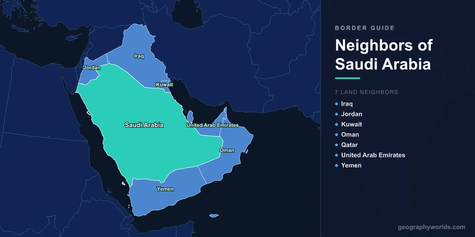
Almost every part of that line was once fought over. Saudi Arabia and the Kingdom of Yemen went to war in 1934, and the Treaty of Taif, signed on 12 May 1934, left the provinces of Asir, Jizan and Najran under Saudi rule while letting border tribes cross without visas. In the east, Saudi forces fought South Yemen in the brief Al-Wadiah War between 27 November and 6 December 1969 and kept the town. Talks resumed after Yemeni unification in 1990, a memorandum of understanding followed on 26 February 1995, and the Treaty of Jeddah of 2000 finally fixed the whole frontier.
The line has become heavily militarised since. Saudi Arabia began building a barrier in 2003, citing terrorism, and clashes with the Houthi movement preceded the Saudi-led military intervention in Yemen in 2015. Human Rights Watch reported that Saudi border guards killed hundreds of Ethiopian migrants and asylum seekers on this frontier between May 2022 and June 2023. For how the same line looks from the south, see the countries that border Yemen.
Iraq: the 811 km Uqair line and its fortified berm
From the Jordanian tripoint, the Iraqi border runs south-east in six straight lines across open desert until it reaches the Kuwaiti tripoint on the Wadi al-Batin. It was drawn in December 1922, when the British High Commissioner in Iraq, Sir Percy Cox, met Ibn Saud and signed the Uqair Protocol, which set Saudi Arabia's borders with both Iraq and Kuwait. The Bahra Agreement of November 1925 confirmed the line, and the protocol also created a Saudi–Iraqi neutral zone just west of Kuwait. That zone was split in 1975 and a final treaty was signed in 1981, though its text became public only in 1991, when Saudi Arabia lodged the agreements with the United Nations after the Gulf War.
The 1990–91 war left lasting damage: Iraq fired Scud missiles into Saudi territory, and the Arar crossing stayed shut for 30 years until it reopened on 18 November 2020. Arar is the main crossing, and traffic through it peaks during the Hajj, when Iraqi pilgrims drive south to Mecca. Since September 2014, when the Islamic State held much of western Iraq, the frontier has been lined with a multi-layered fence and ditch: five layers of fencing, 78 watchtowers, night-vision and radar cameras, all behind an older sand berm about 7 metres high and an 8 km strip of no-man's-land that is swept smooth so that footprints show.
Jordan: Haql, the Gulf of Aqaba and "Winston's Hiccup"
The 731 km Jordanian border begins on the Gulf of Aqaba and runs north-east in nine straight lines to the Iraqi tripoint. Its first version came from the Hadda Agreement of 2 November 1925, negotiated by the British envoy Sir Gilbert Clayton with Ibn Saud, then Sultan of Nejd. That deal handed the Wadi Sirhan and the settlement of Kaf to Nejd while giving Transjordan a short outlet on the Gulf of Aqaba. A treaty of 9 August 1965 redrew the line, producing today's nine segments and giving Jordan about 18 km more coastline on the gulf.
The sharp notch in the northern section is often called "Winston's Hiccup", after a story that Winston Churchill drew it after a long lunch. Historians have rejected the tale: the boundary was not discussed at the 1921 Cairo Conference, and Churchill had no part in the Hadda talks. On the Saudi side the coastal town of Haql sits close to the southern end of the border, and the Jordanian settlement of Mudawwara lies near the line further inland.

Oman: three straight lines across the Rub' al Khali
The 658 km border with Oman runs entirely through the Rub' al Khali, the Empty Quarter, which covers some 650,000 km² across parts of Saudi Arabia, Oman, the UAE and Yemen. It is made of just three straight segments of 91, 233 and 334 km, and the Umm al Samim quicksand area lies on the first bend in the north. King Fahd and Sultan Qaboos signed the treaty at Hafr al-Batin on 21 March 1990; it was ratified in May 1991 and marked on the ground with help from the German aerial-survey firm Hansa Luftbild by 1995. The first official crossing, at Ramlat Khaliya in the far north, opened only in 2006. More on the desert itself is in our guide to the Rub' al Khali.

United Arab Emirates: the 1974 Treaty of Jeddah and Buraimi
The 457 km frontier with the UAE is four straight lines of 26, 166, 265 and 12 km, starting on the Gulf coast west of the Ras Khumays peninsula and crossing salt flats such as the Sabkhat Matti on the way to the Omani tripoint. Its history runs through the Buraimi Oasis. On 31 August 1952 a Saudi party of about 80 men occupied the village of Hamasa there; an arbitration tribunal in Geneva collapsed in 1955, and on 25 October that year the Trucial Oman Levies retook the oasis.
King Faisal and Sheikh Zayed bin Sultan Al Nahyan signed the Treaty of Jeddah on 21 August 1974, and Saudi Arabia recognised the UAE the same day. The text was not lodged with the UN until 1995, the UAE has never ratified it, and it says the written terms differ from what was agreed orally. After the Buraimi episode Britain declared it would treat a slightly modified version of the 1935 "Riyadh line" as the frontier, and the same line later became the basis of the Oman settlement. The main road crossing between the two countries is at Al Ghuwaifat.
Kuwait: from neutral zone to divided zone
At 221 km, the Kuwaiti border runs east from the Wadi al-Batin in a 90 km straight line, bends south through irregular sections, then reaches the Gulf in a final 70 km straight. The Uqair Protocol of 2 December 1922 left a 5,770 km² neutral zone in the south-east where both sides held equal rights, a compromise for the Bedouin who moved freely across it. Oil was found there in March 1953, and the two governments agreed on 7 July 1965 to partition the zone; the division took final effect in 1969–70, though oil from the old zone is still shared. The main crossings today are at Salmi and Nuwaiseeb. Before any line existed, Ibn Saud had tried to annex Kuwait in the Kuwait–Najd War of 1919 and then blockaded it. In 1991, after Iraq had occupied Kuwait, Iraqi forces crossed this border to attack the Saudi coastal town of Khafji.
Qatar: an 87 km border that was shut for three and a half years
The shortest of the seven runs in a broad arc from the Gulf of Salwa to the inlet of Khor Al Adaid, and it is Qatar's only land border. The 1974 Saudi–UAE treaty gave Saudi Arabia a corridor to Khor Al Adaid, which is why Qatar and the UAE do not touch. A 1965 agreement was disputed for decades; in September 1992 a clash at the Al-Khufus post killed two Qatari soldiers, and the line was settled only by an agreement in 1999 and a final treaty in 2001. When relations broke down in 2017 the border at Salwa was closed, and in June 2018 Saudi Arabia announced a 61 km Salwa Canal that would have turned Qatar into an island. The crossing reopened on 4 January 2021, and a demarcation completed in November 2021 confirmed Khor Al Adaid's southern shore as Qatari.
Bahrain, Egypt and Iran: the neighbours across the water
Bahrain is the closest maritime neighbour. The King Fahd Causeway, opened on 26 November 1986, runs 25 km from Khobar to Al Jasra on five bridges and seven embankments, and its customs and immigration post sits on an artificial island in the middle. Because both countries' frontiers meet on that island, some lists count a land border of only about 196 m there.

In the north-west, the islands of Tiran and Sanafir at the mouth of the Gulf of Aqaba had been under Egyptian administration since 1950; Egypt agreed in April 2016 to transfer them back to Saudi Arabia. Across the Red Sea lie Egypt, Sudan and Eritrea, and across the Persian Gulf lies Iran. Seen together, the seven land frontiers and these sea neighbours wrap around a country of roughly 2.15 million km², and our page on how big Saudi Arabia is puts that area beside other countries.