
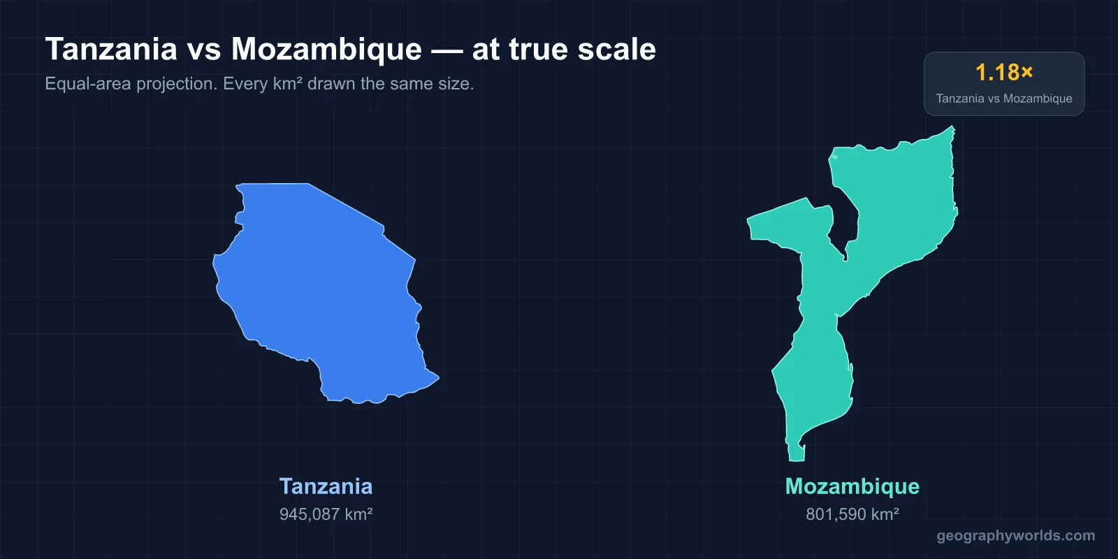
Tanzania is bigger, more populous and richer than Mozambique. It covers about 947,300 km² to Mozambique’s 801,590 km². It had about 67.5 million people in 2024 against about 34.9 million, almost twice as many. Its nominal GDP per capita is about US$1,280, compared with about US$663 in Mozambique (IMF, 2025). Tanzania’s capital is Dodoma, though Dar es Salaam is its largest city. Mozambique’s capital and largest city is Maputo, in the far south. Tanzania uses Swahili as its national language, with English in higher education, the higher courts and diplomacy. Portuguese is the official language of Mozambique. The two countries share a border of about 756 km, most of it along the Ruvuma River. Mozambique is ahead on one clear measure, its coastline, which is much longer than Tanzania’s. The eight questions below take each comparison in turn.
Which is bigger, Tanzania or Mozambique?
Tanzania is larger by about 146,000 km², roughly the size of Nepal. Its official area of 947,303 km² includes about 6.4 percent water, because Tanzania holds large shares of three of Africa’s Great Lakes. It shares Lake Victoria, Africa’s largest lake, and Lake Tanganyika, its deepest, and it also borders Lake Malawi, known in Tanzania as Lake Nyasa. It also includes the islands of Zanzibar and Pemba. Only about 2.2 percent of Mozambique is water. Its lakes are Lake Niassa (Lake Malawi), Lake Chiuta, Lake Shirwa and the Cahora Bassa reservoir on the Zambezi.
The countries also differ in shape. Tanzania is compact, roughly square. Mozambique is long and narrow, stretching from about 10° to 27° south along the Indian Ocean. It borders six countries: Tanzania, Malawi, Zambia, Zimbabwe, South Africa and Eswatini. The Zambezi divides it into a hillier, plateau-covered north and broader lowlands to the south.
Their rivers drain in different directions too. Much of northern Tanzania drains into Lake Victoria and from there into the Nile, and the west drains into Lake Tanganyika. Rivers such as the Rufiji and the Ruvu flow east to the Indian Ocean. Mozambique is drained by five principal rivers, and the Zambezi is by far the largest. It enters the country from Zambia and Zimbabwe, passes the Cahora Bassa dam in Tete Province and reaches the sea on the central coast. So while much of Tanzania’s rain ends up in the Nile basin, Mozambique carries water from the interior of southern Africa to the Indian Ocean.
Which has more people?
Tanzania, by about two to one. Its 2022 census counted 61,741,120 people, and the 2024 estimate is about 67.5 million. Mozambique had about 34.9 million in 2024. Population density is about 65 people per km² in Tanzania and about 44 per km² in Mozambique.
The largest cities also differ in scale. Dar es Salaam has more than 7 million people, making it the largest city in East Africa and the fifth-largest in Africa. In 1974 Tanzania announced it would move its capital inland to Dodoma, which had 765,179 people in 2022 and has recently become the country’s third-largest city. Maputo had 1,088,449 people in 2017, and its metropolitan area, including Matola, had about 2.7 million. Maputo is less than 120 km from the borders of Eswatini and South Africa, so Mozambique’s capital is at the opposite end of the country from Tanzania.
Which is richer?
Tanzania, although both countries are poor by world standards. IMF figures for 2025 give Tanzania a total GDP of about US$89 billion, nearly four times Mozambique’s US$23.8 billion. Per person, Tanzania is almost twice as well off in nominal terms and about two and a half times as well off once prices are adjusted, as the chart below shows. On the Human Development Index for 2023, Tanzania scores 0.555 and Mozambique 0.493.
Mozambique’s economy has also been set back by the civil war of 1977 to 1992 and by natural disasters. Cyclone Idai in March 2019 killed more than 1,500 people across Mozambique, Zimbabwe and Malawi and is the deadliest tropical cyclone recorded in the South-West Indian Ocean. Since 2017 an Islamist insurgency has been fought in Cabo Delgado, the province bordering Tanzania, and civilians have been its main targets.
Which is higher?
Tanzania, by a very wide margin. Mount Kilimanjaro, in the north-east near the Kenyan border, rises to 5,895 m (19,341 ft). It is the highest mountain in Africa and the highest free-standing mountain above sea level in the world. Mozambique’s highest point is Monte Binga in the Chimanimani Mountains on the Zimbabwean border, at about 2,436 m. That is less than half the height of Kilimanjaro.

Tanzania also shares Africa’s deepest lake. Lake Tanganyika, on its western border, reaches a maximum depth of 1,471 m and is the second-deepest lake in the world after Lake Baikal. On land, both countries bottom out at the same place: sea level on the Indian Ocean coast. Its rugged areas are the Niassa, Namuli and Angonia highlands north of the Zambezi, the Chimanimani range, and Mount Gorongosa (1,863 m), whose streams feed the floodplain of Gorongosa National Park. Gorongosa covers more than 4,000 km² at the southern end of the Great Rift Valley, and at one time it held some of the densest wildlife populations in Africa. Tanzania’s best-known reserve is on a larger scale. Serengeti National Park, established in 1940, covers 14,763 km² and hosts the world’s largest annual animal migration, with more than 1.5 million wildebeest and about 250,000 zebra. Kilimanjaro’s routes and ecology are covered in our Mount Kilimanjaro guide.
Which has the longer coastline?
Mozambique, clearly. Its Indian Ocean coast runs for about 2,470 km, compared with Tanzania’s 1,424 km. Most of it faces the Mozambique Channel, the stretch of sea between the African mainland and Madagascar. Mozambique’s continental shelf reaches up to 140 km wide off Beira and holds its most important fishery. The Bazaruto Archipelago lies off the central coast, and Maputo Bay lies in the far south.
The country is named after a small island on this coast. The Island of Mozambique, off Nampula Province, was a Swahili trading town by the 14th century. The Portuguese made it the capital of Portuguese East Africa, and it stayed the capital until 1898. It is now a UNESCO World Heritage Site with about 14,000 permanent residents.

Its Fort of São Sebastião, begun in 1558 and about fifty years in the building, is the oldest complete fort still standing in sub-Saharan Africa. Tanzania’s shorter coast has its own centres of Swahili trade, above all Zanzibar and Dar es Salaam. More on the waterway itself is in our guide to the Mozambique Channel.
Where exactly do Tanzania and Mozambique meet?
Along the Ruvuma River. The river is 998 km long and rises on a plateau about 1,000 m high east of Lake Malawi. For most of its course it forms the 756 km border before reaching the Indian Ocean. For decades there was no fixed road crossing. Presidents Julius Nyerere and Samora Machel proposed a bridge in 1975, but work stopped in the early 1980s when the money ran out. Foundation stones were finally laid in October 2005, and the Unity Bridge at Negomano, about 720 m long, was opened by the two countries’ presidents on 12 May 2010.
The river is a political line more than a cultural one. South of it, the Makonde Plateau in Mozambique is covered in miombo woodland. Yao, spoken inland in northern Mozambique, is very close to the Mwera language of Tanzania’s Rondo Plateau just north of the river, and Swahili itself continues across the border along the coast.
Which became independent first?
Tanzania, by more than a decade. Tanganyika became independent from Britain on 9 December 1961, and Zanzibar on 10 December 1963. After the Zanzibar Revolution, the two united on 26 April 1964, and the new country’s name joined theirs.
Mozambique had to fight for independence, and Tanzania played a direct part. FRELIMO, the Mozambique Liberation Front, was founded in Dar es Salaam on 25 June 1962 by merging three exile movements, and it kept its headquarters there under Eduardo Mondlane. The war of independence began on 25 September 1964. After the Carnation Revolution in Lisbon in 1974, the Lusaka Accord led to independence on 25 June 1975, thirteen years to the day after FRELIMO’s founding. Civil war with RENAMO followed from 1977 until the Rome General Peace Accords of 4 October 1992. FRELIMO has governed Mozambique ever since independence.
Which languages do people speak?
Swahili links Tanzania together. More than 100 languages are spoken there, but only about 10 percent of Tanzanians speak Swahili as a first language, while up to 90 percent speak it as a second. President Nyerere promoted it deliberately to unite the country’s many ethnic groups. Swahili is used in parliament, the lower courts and primary schools, and English in secondary schools, universities and the higher courts.
In Mozambique, Portuguese is the only official language, and it is spoken by about 50.3 percent of the population. Bantu languages dominate everyday life. The eMakhuwa group is widespread in the north, and Sena, Nyanja, Yao and Makonde are each spoken in their own regions. Near the Tanzanian border the two language worlds overlap. Swahili is spoken on a short stretch of the Mozambican coast, and Kimwani, regarded as a dialect of Swahili, is spoken farther south towards the Island of Mozambique. For the same kind of comparison with Tanzania’s northern neighbour, see Kenya against Tanzania.