
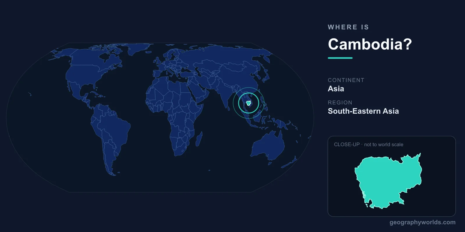
Cambodia is located in mainland Southeast Asia, on the southern part of the Indochinese Peninsula, bordered by Thailand to the west and northwest, Laos to the northeast, Vietnam to the east and southeast, and the Gulf of Thailand to the southwest. The country lies entirely within the Northern and Eastern Hemispheres, roughly between latitudes 10 and 15 degrees north and longitudes 102 and 108 degrees east. Its capital, Phnom Penh, sits near the heart of the country where several major rivers converge, making Cambodia one of the most centrally positioned nations in continental Southeast Asia.
Where Exactly Is Cambodia on the Map?
Cambodia occupies a central position in continental Southeast Asia, tucked between its larger neighbors Thailand and Vietnam. If you picture the Indochinese Peninsula, Cambodia is the modest-sized nation in the south-central portion, with a short coastline opening onto the Gulf of Thailand. It covers an area of about 181,035 square kilometers, making it comparable in size to the U.S. state of Oklahoma, or to countries such as Syria and Uruguay.
The nation sits at a strategic crossroads of the region. Its location has historically placed it along key overland and river trade routes linking the South China Sea hinterland with the interior of mainland Asia, and today it remains a member of ASEAN (the Association of Southeast Asian Nations), deeply connected to its neighbors through commerce and shared waterways. Phnom Penh lies only around 230 kilometers from Ho Chi Minh City in Vietnam and roughly 660 kilometers from Bangkok in Thailand, underscoring how tightly Cambodia is woven into the fabric of the region.
For travelers and students orienting themselves, Cambodia is best understood as the keystone of the lower Mekong region. The river that defines so much of its geography enters from Laos in the north, threads through the country, and continues into Vietnam's delta before reaching the sea — a single thread linking four nations.
Cambodia's Neighbors and Borders
Cambodia shares land borders with three countries, plus a coastline along the Gulf of Thailand:
- Thailand — to the west and northwest, the longest of Cambodia's land boundaries at roughly 800 kilometers, running through forested uplands and lowland plains.
- Laos — to the northeast, the shortest border at around 555 kilometers, near the upper reaches of the Mekong River.
- Vietnam — to the east and southeast, where the fertile Mekong Delta region connects the two countries across roughly 1,150 kilometers of frontier.
The southwestern edge of the country meets the sea, giving Cambodia roughly 440 kilometers of coastline and port access at Sihanoukville, its principal deep-water port. These borders have shaped centuries of cultural exchange, with Thai, Vietnamese, and Lao influences blending alongside the country's distinctive Khmer heritage. They have also been the subject of historical disputes, most notably around the ancient Preah Vihear temple on the Dângrêk escarpment, which the International Court of Justice confirmed as Cambodian.
The Landscape: Rivers, Plains, and a Great Lake
Cambodia's geography is defined by water. At its center lies a broad, low-lying alluvial plain, surrounded by mountains and uplands along the edges. The Mekong River, one of the great rivers of Asia, flows from north to south through the eastern part of the country, while the Tonlé Sap — Southeast Asia's largest freshwater lake — dominates the northwest.
The Tonlé Sap is famous for its reversing river: during the monsoon season, the Mekong's swollen flow pushes water backward into the lake, dramatically expanding its size from roughly 2,500 square kilometers in the dry season to as much as 16,000 square kilometers at the peak of the floods. This seasonal pulse supports one of the world's most productive inland fisheries and feeds the fertile rice plains that sustain much of the population. The lake and its floodplain are recognized as a UNESCO Biosphere Reserve.
Beyond the central lowlands, the terrain rises into the Cardamom and Elephant Mountains in the southwest — home to some of mainland Southeast Asia's largest surviving tracts of rainforest — and the Dângrêk Mountains, whose cliffs form part of the northern border with Thailand. The highest point in the country is Phnom Aural, reaching about 1,810 meters in the Cardamom range. These ranges frame the plains and give Cambodia a varied landscape despite its modest size.
Climate and Seasons
Cambodia has a tropical monsoon climate with consistently warm temperatures year-round, generally ranging between 25 and 35 degrees Celsius. Rather than the familiar four seasons, the year divides into two main periods governed by the monsoon winds:
- Wet season (May to October): The southwest monsoon brings heavy rainfall, swelling the Mekong and Tonlé Sap and turning the central plains lush and green.
- Dry season (November to April): The northeast monsoon brings cooler, drier air from late November, followed by the hottest months of March and April.
This climate makes Cambodia ideal for wet-rice cultivation, the backbone of rural life, and the rhythm of flood and drought continues to shape agriculture, fishing, and settlement patterns much as it has for over a thousand years.
Phnom Penh and Key Locations
The capital, Phnom Penh, lies in the south-central part of the country at the confluence of the Mekong, Tonlé Sap, and Bassac rivers — a meeting point often called the "Chaktomuk," or four faces. As the political, economic, and cultural hub, it anchors Cambodia's national life and is home to more than two million people.
To the northwest, near the town of Siem Reap, stands Angkor Wat, the vast temple complex built by the Khmer Empire in the 12th century and now the country's most iconic landmark and a UNESCO World Heritage Site. Often described as the largest religious monument in the world, it draws millions of visitors each year. Along the southern coast, Sihanoukville and the island-dotted Gulf of Thailand offer beaches and ports, while Battambang to the west serves as an important agricultural center, and Kampot in the south is known for its pepper and riverside charm.
People, Language, and Government
Cambodia is home to roughly 17 million people, the great majority of whom are ethnic Khmer, with minorities including Cham, Chinese, Vietnamese, and various highland groups. The official language is Khmer, written in its own distinctive script descended from ancient Indian writing systems. Theravada Buddhism is the dominant religion and shapes the rhythm of daily life, from village pagodas to national festivals such as Khmer New Year and the Water Festival.
The country operates as a constitutional monarchy, with a king as head of state and a prime minister leading the government. Its currency is the Cambodian riel, though the U.S. dollar circulates widely alongside it. Cambodia uses Indochina Time (UTC+7), the same time zone as neighboring Thailand, Laos, and Vietnam. For more on the nation's history, culture, and travel highlights, see our Cambodia country guide.
Key Facts
- Continent: Asia (Southeast Asia, Indochinese Peninsula)
- Capital: Phnom Penh
- Bordering countries: Thailand, Laos, Vietnam
- Area: approximately 181,035 square kilometers
- Population: roughly 17 million
- Official language: Khmer
- Time zone: Indochina Time (UTC+7)
Frequently Asked Questions
What continent is Cambodia in?
Cambodia is in Asia, specifically the Southeast Asia region on the Indochinese Peninsula. It lies in both the Northern and Eastern Hemispheres, between roughly 10 and 15 degrees north latitude.
What countries border Cambodia?
Cambodia borders three countries: Thailand to the west and northwest, Laos to the northeast, and Vietnam to the east and southeast. It also has about 440 kilometers of coastline along the Gulf of Thailand.
Is Cambodia near Thailand and Vietnam?
Yes. Cambodia sits directly between Thailand and Vietnam, sharing land borders with both. Bangkok and Ho Chi Minh City are each within a short flight or overland journey of Phnom Penh.
What is the capital of Cambodia and where is it located?
The capital is Phnom Penh, located in the south-central part of the country where the Mekong, Tonlé Sap, and Bassac rivers meet — a confluence known as the Chaktomuk.
How big is Cambodia?
Cambodia covers about 181,035 square kilometers, roughly the size of the U.S. state of Oklahoma. Despite its modest area, it ranges from coastal lowlands and a vast central plain to mountain ranges rising above 1,800 meters.