
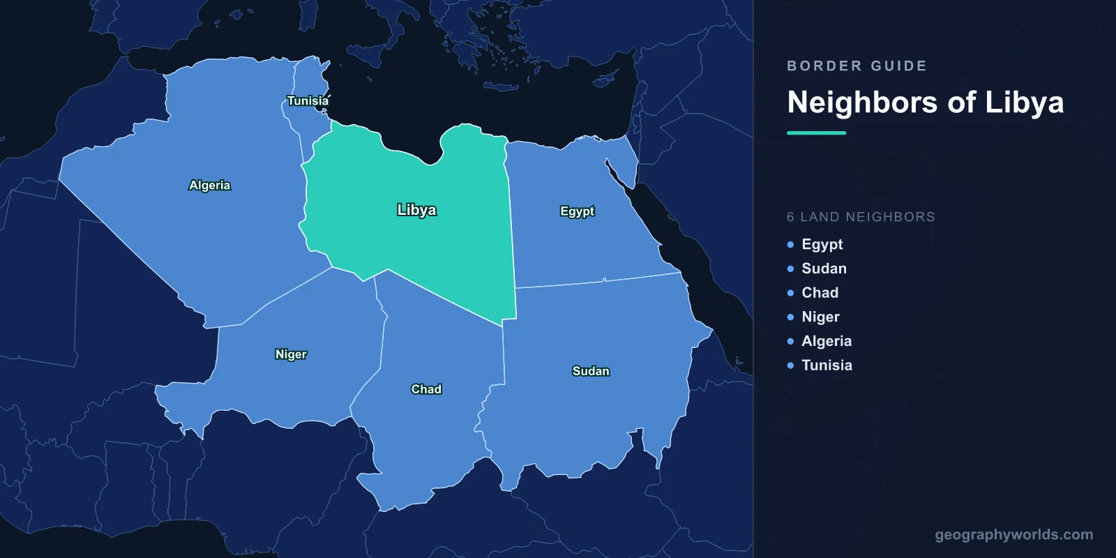
Six countries meet Libya on land: Egypt and Sudan to the east, Chad and Niger to the south, Algeria and Tunisia to the west. Those six lines total 4,339 km. Egypt has the longest share at 1,115 km, followed by Chad at 1,050 km, Algeria at 989 km, Tunisia at 461 km, Sudan at 382 km and Niger at 342 km.
Add the 1,770 km Mediterranean coastline and Libya's perimeter runs past 6,000 km around a country of 1.76 million km². Fewer than seven million people live inside it, and the overwhelming majority of them live within a hundred kilometres of the sea. Everything else is Sahara, which explains almost everything about how these borders look and behave.
Ruled Lines, With One Coastal Exception
Trace Libya's outline and you notice how little of it curves. The eastern boundary with Egypt is essentially a single north–south line following the 25th meridian east, running some 1,115 km down to the point where it meets the 22nd parallel — the corner where Libya, Egypt and Sudan converge. The Sudanese section is one long diagonal heading south-west. The Algerian and Nigerien sections are chains of straight segments joined at surveyed turning points.
There is a reason for that. Boundary-makers use rivers, watersheds and ridgelines where they exist, and in the central Sahara they mostly do not. Libya has no permanent rivers at all. What was left to the negotiators was latitude, longitude and the occasional named well or oasis, so they used those. The one boundary with genuine terrain in it is the Chadian one, which brushes the Tibesti massif — volcanic mountains rising well above 3,000 m, where Libya's own high point, Bikku Bitti at 2,267 m, sits on the frontier itself.
Only the Tunisian border departs from the pattern in a way that matters on the ground, because only there does the line cross populated, cultivated country rather than gravel plain.
Egypt and Sudan: The Empty Eastern Edge
The Libya–Egypt boundary was inherited from the Ottoman period and refined by Italy and Britain during the 1920s. It runs down the 25th meridian for most of its length before bending north-west near the coast to reach the Mediterranean at the Gulf of Sollum. The only functioning land crossing on the entire 1,115 km is at Amsaad on the Libyan side, facing Sallum in Egypt — a single gate for a border longer than Italy. Everything south of the coastal strip is the Libyan Desert, including the Great Sand Sea, which is about as close to genuinely uninhabited as anywhere on Earth. Our guide to Egypt's neighbours follows the same line from the far side.
Sudan's 382 km is Libya's second-shortest boundary and, by a distance, its most remote. From the tripoint at 22°N and 25°E it runs south-west across the desert margins towards the Ennedi and Darfur country where Libya, Chad and Sudan meet. There is no established road crossing. What traffic exists is informal, and the corridor has repeatedly drawn attention as a route for fighters and weapons moving between conflicts in Libya, Chad and Darfur — a pattern documented in successive United Nations panel reports.
Chad, and a Strip Claimed on a Treaty That Never Took Effect
The 1,050 km southern boundary with Chad produced the longest-running territorial dispute in Libya's history, over a band of land known as the Aouzou Strip: roughly 1,000 km long, about 100 km deep, and around 114,000 km² in area — larger than Bulgaria.
The Document at the Centre of It
On 7 January 1935, Pierre Laval of France and Benito Mussolini signed the Treaty of Rome, part of a short-lived attempt to keep Italy on side against Germany. Among its terms, France would transfer a strip of territory from French Equatorial Africa to Italian Libya. Both parliaments approved it, but the instruments of ratification were never exchanged, and relations collapsed later that year when Italy invaded Ethiopia. The treaty consequently never entered into force.
Libya, after Muammar Gaddafi took power, argued that the 1935 agreement nonetheless reflected the correct boundary and that earlier arrangements had never validly fixed the line. Libyan forces occupied the strip in 1973. Chad rejected the claim throughout, holding that the boundary had been settled by a Franco-Libyan treaty of friendship and good neighbourliness signed on 10 August 1955, which referred back to colonial-era instruments including an Anglo-French declaration of 1899.
From the Toyota War to The Hague
Fighting over the strip and over Chad's north ran intermittently from 1978. The decisive phase came in 1987, when Chadian columns mounted on light pickup trucks — which gave the campaign its nickname — overran the Libyan air base at Ouadi Doum in March and struck Maaten al-Sarra inside Libya in September. A ceasefire followed within days.
On 31 August 1989 the two governments signed an accord in Algiers agreeing to settle the question politically within a year and, failing that, to put it before the International Court of Justice. They failed, and the Court heard the case. On 3 February 1994, by sixteen votes to one, it held that the boundary was the one defined by the 1955 treaty — placing the Aouzou Strip in Chad. Libya accepted the judgment and completed its withdrawal by 31 May 1994, verified by a small UN observer mission, UNASOG, which finished its work and closed inside six weeks. Two states that had fought a war over the ground handed it to a court and abided by the answer. Chad, whose 1.28 million km² makes it the fifth-largest country in Africa, would have been meaningfully smaller had the ruling gone the other way.
Niger, Algeria and the Salvador Pass
The 342 km Libya–Niger boundary is the shortest of the six and among the most heavily travelled per kilometre, because a single desert route funnels through it. The crossing at Toummo, at the foot of the Mangkhour escarpment, is the gate on the classic trans-Saharan road running Agadez–Dirkou–Toummo–Sabha. For decades that road carried labour migration north and goods south. Since 2011 it has also carried a great deal that neither government wants on it. Niger's vast, thinly garrisoned north makes the route difficult to police from either end.
West of Toummo, where Libya, Niger and Algeria come together, lies the Salvador Pass — Passe de Salvador, a gap in the escarpment on the Niger side of the corner. The wedge of desert around it, sometimes called the Salvador Triangle, has become one of the best-known smuggling corridors in the Sahara, used to move fuel, cigarettes, weapons and people between the three states precisely because it sits at the point furthest from anybody's administrative centre.
The 989 km Algerian border itself is another series of straight segments, inherited from Franco-Italian and later Franco-Libyan arrangements. Near its northern end sits Ghadames, an ancient walled oasis close to the junction with Tunisia and one of the few genuinely old settlements on any of Libya's western frontiers. Algeria closed the border to normal traffic in 2011 and has kept it militarised since, treating the whole southern flank as a security zone rather than a trade route.
Tunisia: The One That Actually Moves
Everything about the Tunisian boundary is different in kind. It is short, it is northern, it touches the sea, and it runs through inhabited country. The southern portion was fixed by a Franco-Ottoman convention signed on 19 May 1910, before Italy took Libya at all.
The crossing at Ras Ajdir, near Ben Gardane on the Tunisian side, is the busiest land border Libya has by a wide margin, carrying commercial traffic, medical travel and family movement in both directions. In the spring of 2011 it became the exit route for hundreds of thousands of people leaving Libya during the uprising, with UN agencies running camps on the Tunisian side to absorb the flow. A second crossing at Dehiba–Wazin, further inland, handles a smaller share.
The Six, Compared
| Neighbour | Length | Character of the line | Main crossing |
|---|---|---|---|
| Egypt | 1,115 km | The 25th meridian east, almost the whole way | Amsaad – Sallum |
| Chad | 1,050 km | Straight segments past the Tibesti; the former Aouzou dispute | No established post |
| Algeria | 989 km | Surveyed Saharan segments; largely closed since 2011 | Ghadames area (restricted) |
| Tunisia | 461 km | Populated, coastal; fixed by the 1910 convention | Ras Ajdir – Ben Gardane |
| Sudan | 382 km | A single desert diagonal, effectively unmanned | None |
| Niger | 342 km | One route through the escarpment at Toummo | Toummo |
Libya declared its southern boundaries a closed military zone in December 2012, an announcement that mattered less than the map suggests: a state can proclaim 2,000 km of gravel restricted, but garrisoning it is another proposition entirely. Since 2011, control over the Egyptian, Chadian, Nigerien and Algerian frontiers has been exercised in practice by a shifting mix of national forces, armed groups and local communities with their own commercial interests in the traffic.
The result is a country whose boundaries are simultaneously among the most precisely defined anywhere — you can write most of them as coordinates — and among the least present on the ground. Getting all six into the right places around a country this large is harder than it sounds, and the map-location game will tell you within a few rounds whether you can.