
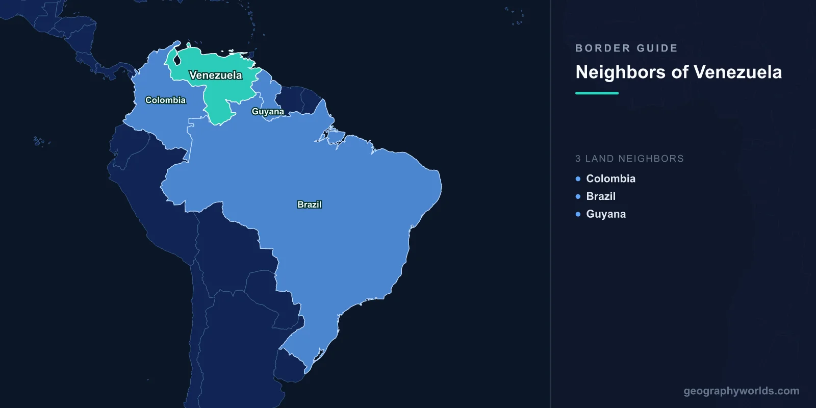
Venezuela borders three countries: Colombia in the west, Brazil in the south, and Guyana in the east. The three lines total 5,267 km — Colombia 2,341 km, Brazil 2,137 km, Guyana 789 km — with roughly 2,800 km of Caribbean and Atlantic coast completing the perimeter.
Three neighbours is a modest number for a country of 916,445 km², and it hides how little the three have in common. One of these borders is a crowded urban seam that has been shut and reopened by presidential decree several times in a decade. One is a jungle watershed with a single road across it and almost no friction at all. And one is the subject of a territorial claim now being argued before the International Court of Justice, over an area larger than England.
Guyana: An Argument Older Than Either Country's Independence
Venezuela claims sovereignty over Guayana Esequiba — everything in Guyana west of the Essequibo River. That is around 159,500 km² of a country whose total area is 214,970 km², so roughly two-thirds of it. Guyana administers the region and rejects the claim entirely. The two positions have been irreconcilable since before Guyana existed as a state.
How the 1899 Line Was Set
The frontier between Venezuela and British Guiana was disputed through the nineteenth century, with British surveyors pushing westward and Venezuela protesting. It became an international crisis in 1895 when the United States, invoking the Monroe Doctrine, pressed Britain to arbitrate. A tribunal of five sat in Paris: two members nominated by Britain, two by the United States acting for Venezuela — one of them a former US president, Benjamin Harrison, argued Venezuela's case — and a Russian jurist, Friedrich Martens, presiding.
The award, delivered on 3 October 1899, gave the great majority of the disputed territory to British Guiana while awarding Venezuela the mouth of the Orinoco and Barima Point, which mattered for control of river access. Venezuela accepted it at the time, and a joint commission demarcated the line between 1900 and 1905.
The Memorandum, and the Repudiation
In 1949 a memorandum written by Severo Mallet-Prevost, a junior American lawyer on Venezuela's 1899 team, was published after his death. In it he alleged the award had been the product of a political bargain struck among the arbitrators rather than a legal determination. Venezuela treats that document as decisive; Guyana regards it as an unverifiable second-hand account written half a century after the fact and never tested in any proceeding.
On the strength of it, Venezuela formally notified the United Nations in 1962 that it considered the 1899 award null and void — deliberately before Guyana's independence in 1966, so that the claim would attach to the incoming state. On 17 February 1966 Britain, Venezuela and British Guiana signed the Geneva Agreement, which acknowledged the dispute and committed the parties to seek a practical settlement. Its Article IV allows the UN Secretary-General to choose a means of settlement if the parties cannot agree on one. A 1970 protocol signed in Port of Spain froze the matter for twelve years; Venezuela declined to renew it in 1982. A UN good-offices process then ran, without resolution, from 1990 until 2017.
The Case Now Before the Court
On 30 January 2018, Secretary-General António Guterres exercised the Geneva Agreement power and selected the International Court of Justice. Guyana filed its application that March. The Court found it had jurisdiction over the validity of the 1899 award in December 2020, and rejected a further Venezuelan preliminary objection in April 2023. The merits remain pending.
Venezuela's stated position is that the Geneva Agreement requires a negotiated settlement and that the Court is not the proper forum, though it has since participated in the proceedings. Guyana's position is that the 1899 award is valid and final. In December 2023 the Court ordered Venezuela to refrain from acting to alter the situation in which Guyana administers the area, and later that month the two presidents met at Argyle in Saint Vincent and the Grenadines and jointly undertook not to threaten or use force. Substantial offshore oil discoveries in Guyanese waters since 2015 have raised what is at stake for both sides.
On the ground, this is Venezuela's least-connected frontier. The line follows the Cuyuni and Wenamu rivers and the highland divide, and there is no paved road crossing between the two countries at all. Travellers overwhelmingly go the long way round, through Brazil.
Colombia: 2,341 km That Open and Shut Like a Door
This is the longest land border either country has. It begins on the Caribbean at the Guajira Peninsula, where the Wayuu have moved between what are now Colombia's La Guajira department and Venezuela's Zulia state for far longer than either government has existed. It runs south through the Serranía del Perijá around the Maracaibo basin, crosses the Andes in Táchira, then dissolves into the Orinoco and Río Negro lowlands, where the last stretch is river and rainforest with almost nobody in it.
Nearly all the movement concentrates at one point. Cúcuta in Colombia and San Antonio del Táchira in Venezuela face each other across the Táchira River, linked by the Simón Bolívar international bridge and, a little downstream, the Francisco de Paula Santander bridge. In ordinary times tens of thousands of people cross daily for work, shopping, school and medical care.
Times have not often been ordinary. Venezuela closed the crossings in August 2015 and deported large numbers of Colombian residents from Táchira; they partially reopened in 2016. Relations broke down again in February 2019 after a confrontation at the bridges over an attempted aid convoy, and the border was shut once more. Pedestrian traffic resumed in stages from late 2021, and after Gustavo Petro took office in Colombia the two governments restored diplomatic relations and formally reopened the border to vehicles on 26 September 2022. The Tienditas bridge, finished in 2016 and left unused for years — it was the structure blocked by containers in the 2019 standoff — finally opened to cargo on 1 January 2023.
Behind the closures sits the largest displacement in the hemisphere's recent history: more than seven million Venezuelans have left the country since 2015, with Colombia hosting by far the greatest share of them. Our companion piece on Colombia's neighbours looks at how that has reshaped the country on the other side of the bridges.
Brazil: The Quietest Long Border in South America
Venezuela's 2,137 km southern boundary is nearly as long as the Colombian one and behaves nothing like it. It was settled by a treaty of limits signed on 5 May 1859 and follows the continental watershed — the Serra Pacaraima and Serra Parima ranges, which divide the Orinoco basin from the Amazon. It is one of the tidier applications of the watershed principle in South America, with one geographical joke buried inside it: the Casiquiare, a natural channel wholly within Venezuela, links the Orinoco to the Rio Negro and so quietly connects the two basins the border was drawn to separate.
The eastern end of the line arrives at Mount Roraima, the 2,810 m tepui whose flat summit is the meeting point of Venezuela, Brazil and Guyana — one of the few tripoints in the world that is a genuine landmark rather than a survey marker.
There is exactly one road crossing along the entire border: Santa Elena de Uairén in Venezuela's Bolívar state and Pacaraima in Brazil's Roraima, about fifteen kilometres apart on the BR-174 running down to Boa Vista and on to Manaus. That single road has carried a great deal. Boa Vista drew its electricity from Venezuela's Guri dam via a transmission line from 2001 until repeated failures pushed Brazil to disconnect in 2019. The same road became the main overland route for Venezuelan migrants entering Brazil, and Pacaraima — a town of a few thousand — saw serious unrest in August 2018 as arrivals mounted. West of the road, Yanomami territory straddles the boundary on both sides, and illegal gold mining moving across it has been a persistent concern for both governments. The wider setting is covered in our guide to Brazil's ten neighbours.
Three Frontiers, Three Different Problems
| Neighbour | Length | Road crossing | Status of the boundary |
|---|---|---|---|
| Colombia | 2,341 km | Cúcuta – San Antonio del Táchira | Agreed on land; maritime delimitation in the Gulf of Venezuela unresolved |
| Brazil | 2,137 km | Pacaraima – Santa Elena de Uairén | Settled by the 1859 treaty and demarcated |
| Guyana | 789 km | None | Contested; case pending at the International Court of Justice |
Venezuela and Colombia also have an unsettled maritime question in the Gulf of Venezuela, complicated by the status of the small Venezuelan island of Los Monjes; talks on it have run intermittently for decades without a treaty.
Put together, the three borders sketch a country facing in three directions at once — outward to the Caribbean and Colombia, inward to the Amazon, and eastward towards a dispute whose outcome will be decided in a courtroom in The Hague rather than anywhere near the Essequibo. If you want to see how well you actually know the outline that all this wraps around, the country-shapes game is a quick and slightly humbling test.